|
Included
in this Georgetown Early Roadways
History section is information I have gathered from articles
by Wilbur F. Thompson, and several oral history projects of
my own. More information will be added as I find it.
Please
let me know if there are more areas you'd like me to explore
or if you have further information. Contact bcolley@snet.net
or phone me at 860-364-7475.
Main
Street, Georgetown
The
history of Main Street Georgetown as a businsess district
dates back to about 1900 but the history of Main Street as
a roadway dates to the 1680's! Main Street was a part of the
"Great Road from Norwalk to Danbury" which was similar
in function to what Route 7 is today. Below is the history
as I know it:
The
Inland Postal/Stage Coach Route
The
postal system of the Mid-1700's was not nearly as extensive
as it is now. There were only about 60 post offices in the
Colonies in 1765, almost all of which were on the coasts or
not more than 60 miles inland. Ben Franklin said in 1766 "...The
posts only go along the sea coasts; they do not, except in
a few instances, go back into the country..."
*The
modern day Post Road that runs along the coast of Connecticut
follows a route similar to the colonial postal road.*
Once
mail reached a point on the "coastal" Post Road close to its
destination it would be sent inland by a post rider, or it
would wait for someone who was traveling in the direction
of the addressee to pick it up and carry it the rest of the
way inland. This latter method was a common practice, and
became an easy way for journeymen, businessmen, traders and
travelers of every type to earn small amounts of money in
the towns they passed through. In towns where there was no
post office- a tavern, inn or store received the local mail.
And thus the stage coaches and the roads they rode over served
an important role in early American transportation and communication.
Inland
roads in the colonial period were poor, colonist did not have
modern conveniences such as bulldozers and excavators to clear
pathways for their travels. Trees and bushes were cut back
with hand-tools and oxen teams were harnessed to remove stumps
and boulders in order to widen the existing footpaths. Yet
even roadways that were wide enough to accommodate wagons
were not always passable as rocks, rain, sleet and/or snow
created hazardous road conditions. It is for this reason that
in early colonial times the use of horse and wagon was more
common in village or city settings while in rural locations
teams of oxen (which were stronger) were used to pull wagons
over the treacherous terrain.
By
the late 1700's turnpike companies were formed with the intent
to improve these rural roads and maintain them (for a fee,
of course). In our area, the Norwalk and Danbury Turnpike
Company was incorporated in 1795 to repair the "Great Road
from Norwalk to Danbury" which ran through Georgetown and
Redding (references to this road date back to the mid-1680's).
One of the toll gates for this road was located on what we
now know as Main Street in Georgetown. This information having
been related to future generations via Georgetown historian
Wilbur F. Thompson:
"North
of the Nichols home (corner of Old Mill Road and Route 57)
was the toll gate across the road, and Uncle David Nichols
collected tolls. This was a heavy timber gate that blocked
the highway. After the tolls were paid, the gate was opened
and the team passed through. Near the gate was a milestone
erected in 1786 by the orders of Benjamin Franklin, who was
Postmaster General at this time. This was the post road from
New York City to Hartford. There is one of these milestones
still standing near Miss Sarah Coley's home (Route 107 across
from Blueberry Hill) on the road north of Georgetown
"
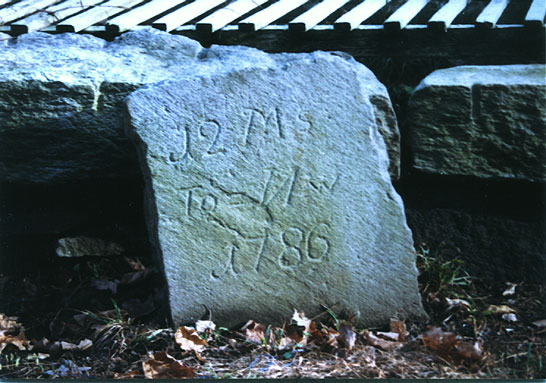
12 Miles to Norwalk
1786
The
second milestone Wilbur writes of is on the corner of Goodsell
Hill and modern day Route 107 in Redding. This milestone,
which still exists, was associated with Darling's Tavern which
served as a way-station for weary travelers and for many years
was the place where fresh horses were put on the stages (it
was the halfway point-12 miles from Norwalk and 12 miles from
Danbury).
The
Danbury and Norwalk stage coach made daily trips across this
turnpike; the fare from Danbury to Norwalk was $1 and from
Georgetown was 50 cents. The stage left Danbury at 2 a.m.
and arrived in Norwalk in time for the passengers to take
a boat to New York the same morning. *It is believed that
tavern-owner, Benjamin Darling, ran a stage coach business
associated with the Danbury and Norwalk Stage.
For
many years, this section of Georgetown served as Redding's
Post Office with mail being delivered to *Boston Corners and
then ridden up to Redding Center on horseback by a Post Rider.
Billy Comstock was Georgetown's first postmaster, appointed
in 1810; Joseph Darling was postmaster from 1823 to 1844.
*It
became known as Boston Corners because it was located in the
"Boston" section of Redding.*
In
addition to stages and postal carriers, great canvas-topped
freight wagons, slow moving ox carts, and horsemen (as this
was the principal method of travel in the time period), all
utilized this turnpike.
The
coming of the railroad to the area in 1852 closed the stage,
postal and freight routes through Redding almost immediately.
Within a month the post office had been relocated to the railroad
depot on Old Mill Road in the Wilton section of Georgetown
and all stage coach companies either moved out of the area
or shifted their focus to transporting passengers from Branchville
Station to the town of Ridgefield.
Georgetown
1852-1900
While
businesses along the turnpike in the Boston District closed
down, businesses along the Norwalk River and the Railroad
opened up. From this period forward, Georgetown grew into
the village we know today. Initially, Old Mill Road housed
a majority of these businesses. The reason behind this was
simple, the railroad depot and the Gilbert and Bennett factories
were located down there, but as Gilbert and Bennett innovated
and expanded so did the village of Georgetown.
The
Gilbert and Bennett Company purchased the land, pond and mill
of rights that would become the "upper factories" in 1848.
They started small - operating a saw mill, sieve factory and
glue factory on this property through the 1860's and were
planning further expansion as the company entered the 1870's.
Then disaster struck, a fire ripped through the upper factories
on May 11, 1874, consuming a majority of the buildings
most
of which were not insured. This would have been a devastating
blow for most companies but Gilbert and Bennett was different,
in just 19 days they had the catastrophe under control. Two
decisions were made that saved the company and ultimately
shifted Georgetown's nucleus from Old Mill Road to North Main
Street. One of those decisions was to incorporate as a joint
stock company, the other was to lobby the Danbury and Norwalk
Railroad to run a spur-line into the mill. Incorporating as
a joint stock company gave them the capital they needed to
rebuild and equip the buildings they had lost and add new
ones. The spur line enabled the company to ship and receive
material more efficiently, and reduce the manpower required
in the process.
The
newly incorporated company went into the field with a vigor,
which within a few years multiplied their sales and output
many times over. The growing company, aided by the convenience
of the railroad, attracted many immigrants and by the early
1900's Georgetown had grown into quite a *diverse community.
*
5 churches in 1 square mile is very diverse! *
Main
Street (changes from a residential to a commercial street)
To
serve the needs of these people more and more "service" businesses
began to arrive in the area and most of them either leased
or purchased real estate on Main Street; Stores and markets
were especially attracted to this stretch of road: Connery's
Store and Perry's Meat & Fish Market were two of the earliest
and most popular but they had plenty of competition. A&P,
Georgetown Market, Kearn's Store, L. Sabilia's Groceries,
First National Stores, Hammelscamp's Meat Market all called
Main Street home at one time or another between 1900 and 1950.
Other
businesses that were located on Main Street during this time
period were: Patsy LoPresti's Shoe Repair, Sabilia's Liquor
Store, Tankus's Clothing Store, Benny's Italian Restaurant
and Bar, Rocco's Pizza, Forgarty's Georgetown Restaurant,
Nick Santenella's Barber Shop, Don Sansevieri's Barber Shop
(Barbershop had a pool room and 2 pool tables), Sanfilipo's
Barber Shop, J.C. Driscoll's Insurance & Real Estate, Steve's
Bakery, Georgetown Electric, William Henry Colley's Blacksmith
shop, Wallace Williams' Jewelry Store with Western Union on
2nd floor, Stocking's Dry Goods, Georgetown Drugs, G&B Liquor,
Connery's Hardware, Building Supplies and Lumber (later DeLuca
Bros. and Sloper Lumber).
Main
Street was aptly named as it was the "main route" through
Georgetown for travelers heading north to Redding. Prior to
the completion of Route 107 in 1955, traffic from Wilton traveled
up Old Mill Road; traffic from Weston came via Route 57/Georgetown
Road as it does today, but was referred to as Route 53. (View
Map)
Route
107
Route
107 greatly impacted both Main Street and Georgetown. It torn
the village apart
literally, reconfiguring not only the flow
of traffic but the streets themselves. Prior to the construction
project, Church Street and Smith Street extended south toward
Old Mill Road. (View
Close-up Map)
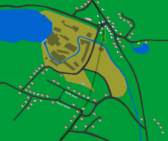
In
the above map, the houses that are grayed out were removed
to make way for Route 107, Smith Street was cut short and
the Berger and Anderson houses became a part of Church Street
South. It almost goes without saying that this was a heartbreaking
experience for the families involved.
The
most damaging impact the Route 107 project had on the area
was likely unforeseen by its engineers yet Mother Nature in
her infinite wisdom did not hesitate to take advantage of
it and quickly. To clear the elevation and railroad tracks
between Smith Street to Main Street a bridge was built to
cover that span. In constructing the roads that would rise
up to meet this bridge, the flow of the Norwalk River and
the landscape that surrounded it were completely altered.
What was once flat land was built up into hills, in the process
the Norwalk River and the tributaries that once flowed freely
into it were redirected into culverts and pipes designed to
drain through these newly configured hillsides. Georgetown's
Main Street had been converted from a valley into a basin.
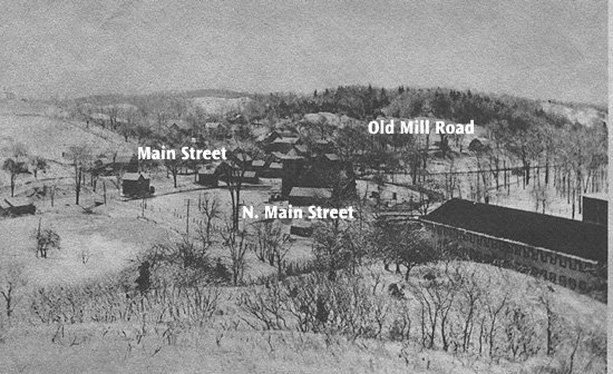
Notice how flat
it use to be in Georgetown
(The Stone Church is in the center of this photo, circa 1900)
During
the October floods of 1955 these new roadside hills trapped
the flood waters that flowed into Main Street and their drains
could not handle the volume of water. The water came from
a number of sources:
- From Perry's
Pond, Gilbert and Bennett Brook and rain waters flowing
off Gilbert's Hill (Meadow Ridge).
- From Vidmark's
Pond on Covenant Lane and rain waters flowing off Highland
Avenue.
- From the Norwalk
River.
Sheila Fogarty Johnson noted the impact of the new overpass in her recollection
of the flood several years ago:
"The
normally tiny brook on the western side of Main Street, which
had risen and receded all summer, was up and over its banks.
Because of the construction of the new overpass, the water
had nowhere to go."
With
nowhere to go the water continued to rise, several reports
claim it rose to 18 feet on Main Street.
The
flood damage was extensive, The Wilton Bulletin reported the
following:
"The
new Calso Building, which housed Sansevieri's new Barber Shop,
J.C. Driscoll's Insurance and Real Estate suffered heavy damage.
Steve's Bakery was considered a complete loss. Bonsignore's
Market was also a total loss. The Local Shoemaker Patsy LoPresti,
Georgetown Electric, Sabilia's Liquor store, Georgetown Restaurant,
Benny's Restaurant, Perry's Market all ruined."
*Sansevieri's
new Barber Shop opened just 3 weeks prior to the flood, J.C.
Driscoll's Insurance and Real Estate opened 1 week prior to
the flood, Steve's Bakery opened 2 weeks prior to the flood.
*
Many
Main Street merchants decided not to return. For those that
did return the clean-up lasted at least a month as basements
had to be pumped, buildings had to be scrubbed and disinfected,
floors refinished, goods re-ordered and stacked. And yet despite
all efforts, some flood damage just wouldn't go away:
"For
years, when it was damp, the buildings in town smelled of
kerosene, which had soaked into the boards." -Sheila Fogarty Johnson
Main
Street 1960 - Present
Coming
soon.
Back
to TOP | Back to Redding
Section | Back to Georgetown
Section
|