|
Quick
Links:
Creation
of the Israel Putnam Memorial Camp Ground, Park
Improvements, Expansion
of the Park, Old Put Club
, Photos, Historical
Sketch of Putnam Phalanx
A
Disney Movie at Putnam Park!
Putnam Park was recently used as a location for a scene in
Old Dogs, a Disney film starring John Travolta and
Robin Williams.
Mr.
Travolta fielded questions from the press about shooting scenes
around the state. The shoot is going wonderfully. The towns
people have been treating us well, he said. Each state allows
certain opportunities to do movies. This year Connecticut
is winning as the most ideal state to film in.
Two
weeks ago, the Disney crew was at the Redding Community Center
filming another scene for the movie. Next week (Aug. 20th),
the crew is expected to film scenes at the Redding Country
Club.
When
asked about filming in Redding specifically, Mr. Travolta
said Putnam Park is the perfect location for the scene which
is pivotal in the movie.
There
is no better spot for this particular scene, he said.
The
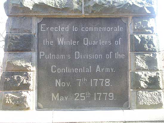
History of Putnam Memorial State Park
in Redding, Connecticut
The
following information was taken from: "The Winter
Campaign of Starving" Archaeological Investigations at
Putnam Memorial State Park in Redding and Bethel Connecticut.
By Ricardo J. Elia and Brendan J. McDermott
Creation
of the Israel Putnam Memorial Camp Ground
When
the army broke camp, in accordance with custom, the barracks
were burned, the chimneys fell in different directions which
is still distinguishable in most cases, and then with time
became apparently only heaps of stone. (Report 1903: 8) *Recent
research indicates the barracks were not burned, wood was
valuable back then.
The
deserted camp ground was left to its former solitude, and
in the course of a few years, became overgrown with trees
and a thicket of underbrush; and it was not strange, that
after the passing of a few generations, even the location,
or the history of the camp ground, was almost unknown. (Report
1915: 8)
The
movement to preserve and memorialize the site of the winter
quarters of 1778-1779 in Redding began in the late 19th century.
Although the details of this movement are not recorded, it
is likely that the initial efforts were made by local citizens
of Redding, especially Charles B. Todd, the local historian,
and Aaron Treadwell, the landowner who donated the first tract
of land that would become the Israel Putnam Memorial Camp
Ground.
The
first official action leading to the creation of a state park
on the site of the encampment at Redding was the passage by
the Connecticut legislature, in January, 1887, of a resolution
to establish a committee "to investigate and report at
once on the practicability and desirability of obtaining for
the State the old Israel Putnam Camp Grounds in the town of
Redding, on which traces of said encampment still exist, and
the erecting thereon of a suitable monument or memorial"
(Todd 1913: 7). The legislative committee visited the site
in February, 1887, which they described in a special report,
dated February 9.
The
heaps of stone marking the site of the log huts in which the
brigades were quartered, are forty-five in number and are
arranged opposite each other in long parallel rows defining
an avenue some ten yards wide and five hundred feet in length.
These, with others scattered among the crags, admirably define
the limits of the encampment, and form one of the best preserved
and most interesting relics of the Revolution to be found
in the State, if not in the Country. It was here that Putnam
and his brigades wintered in ln 1778-9. (Bartram 1887: 40-41)
The
committee also reported that Aaron Treadwell, the owner of
the site, was willing to donate the land to the state. The
committee recommended that the state accept this offer and
appropriate $1500 for the purpose of erecting a memorial on
the site. The Connecticut legislature passed a resolution
accepting these recommendations on May 4, 1887 (Todd 1913:
9).
Accordingly,
on August 17th, 1887, Aaron Treadwell gave a 12.4 acre parcel
to the state for the sum of "$1 and other considerations
(Redding Land Records 25: 80-82, hereafter RLR)." This
property, the first building block in the eventual construction
of the park, may have been the same one purchased by Treadwell
on June 28, 1877 for $110 from Henry H. Adams viz:
...a
certain piece of land situated in said town of Redding at
the “Old Camp" so called containing 12 acres more
or less and bounded north by land of (Harsock?) Read East
by heirs of Isaac H. Bartram South by Highway and West by
Sherman Turnpike so called in part and in part by land of
grantee... (RLR 24: 63).
This,
in turn, may have been purchased by Adams on April 6, 1865
for $150 from Sally and Huldah Read:
...a
certain piece of or parcel of land lying in said Redding at
the Old Camp so called in quantity 12 acres bounded south
by highway, east by heirs of lsaac Bartram North by Hannah
Read West by Sherman Turnpike in part & in part by Aaron
Treadwell (RLR 21: 154).
At
this point it is impossible to follow the deed trail back
any further. There is no indication of from whom Sally and
Huldah Read purchased the property. There is only one other
reference to the "Old Camp" when Aaron Treadwell
purchased an adjacent parcel on April 9, 1879 for $450 from
Joseph Hill:
...quantity
18 acres more or less at Old Camp so called the same being
pasture and woodland bounded North by heirs of Benjamin B.
Read east by an old road formerly Sherman Turnpike south by
highway leading from Lonetown Schoolhouse... (RLR 24: 298).
From
the beginning, the purpose of preserving the site of the encampment
was to commemorate the winter quarters, not to create an area
for recreation. In a plan presented to the legislative committee
that visited the site, Charles B. Todd explained the rationale
behind the park.
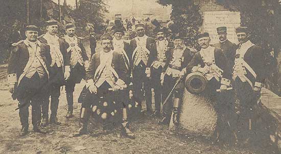
Putnam Phalanx visits
Putnam Park, View
History of this Group
It
is not proposed to erect a pleasure park, but a memorial.
The men it is designed to commemorate were strong, rugged,
simple. Its leading features, therefore, should be of similar
character and of such an historical and antiquarian cast as
to direct the thought to the men and times it commemorates.
The rugged natural features in which the proposed site abounds
should be retained. (Todd 1913: 7).
Todd
proposed adding some new features to the site, while preserving
intact the main line marking the remains of the encampment:
I
would throw over the brooks arched stone bridges with stone
parapets such as the troops marched over in their campaigns
through the Hudson valley. The heaps of stone marking the
limits of the encampment should be left undisturbed as one
of the most interesting features of the place. One might be
reconstructed and shown as it was while in use. A summer house
on the crag guarding the entrance, might be reared in the
form of an ancient block-house, like those in storming or
defending, which Putnam and his rangers learned the art of
war. Such a structure, at this day, would be an historical
curiosity… (Todd 1913: 7-8).
It
was also recommended to erect a monument on the parcel to
commemorate Putnam and his troops. In 1887, a sketch was made
of the encampment site on the portion of the Treadwell property
that would be donated to the state in the following year.
This plan, entitled "Plan of Camp ground of Gen. Israel
Putnams' [sic] Soldiers During Winter of 1778-1779 in Redding,
Connecticut," is located in the Redding Land Records
(vol. 25, p. 81), and is shown in Figure 11. As the earliest
sketch map of the site, this plan is of considerable interest.
In addition to showing the boundaries of the 12.40 acre Treadwell
property, the plan identifies several features that were believed
to be related to the 1778 & 79 encampment. These include
an "old road built by Putnams [sic] soldiers;" a
single hut and the "camp guard quarters," located
in a "grove;" the main "line of soldiers huts,"
consisting of a double row of "remains of chimneys;"
and a cluster of "officers' quarters" located near
the monument.
Park
"Improvements"
The
granite obelisk monument was built in the summer of 1888 under
the supervision of a committee appointed by the governor.
This committee, during its work, had noticed that "the
tract of twelve acres which had been presented by Mr. Treadwell
very inadequately preserved the autonomy of the former camp.
The line of barracks originally extended through the adjoining
fields north nearly a quarter of a mile...." (Todd 1913:
9). This discovery led to the acquisition of additional land
so that the entire winter camp might be included in the park.
The Read property on the north of the Treadwell parcel (Plan
1) was purchased by O. B. Jennings and donated to the state
on February 10, 1888 for "$1 and other good considerations
(RLR 25: 90)." This parcel of almost 30 acres included
the hill later crossed by Overlook Avenue, the so-called bake
oven, and an additional area of firebacks; later Jennings
gave another 52 acres of wooded land west of the camp grounds
(RLR 27: 5). Twenty acres at the northern end of the camp,
including the area around Philip's Cave, the "officers
quarters, and the armies entrance into the camp, were purchased
and donated by I. N. Bartram (Report 1903: 10).
Two
last donations completed the historical nucleus of the park.
A gift of "7 acres 46 sq rods" was made on July
26, 1893 by Helen and Isaac Bartram (RLR 25: 301-3). This
completed the circuit of Overlook Road. The property comprising
the entrance to the park on either side of the Sherman Turnpike
was given on July 23, 1889 by Aaron Treadwell (RLR 25: 150-52).
All of these donated parcels can be picked out individually
on the 1890 surveyed plan of the park, although how the Bartram
donation of 1893 can be recorded on an 1890 plan is unexplained.
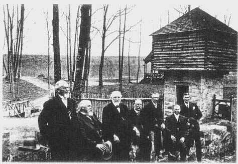
The
activities relating to the creation and maintenance of the
Israel Putnam Memorial Camp Ground were managed by a board
of commissioners appointed by the Connecticut General Assembly
(Fig. 12). The commissioners reported on their activities
beginning in 1889 and every two years thereafter between 1903
and 1915; these reports were published by the slate and are
preserved. The report covering the 15-month period ending
September 30, 1902 is particularly useful, because it contains
a comprehensive summary of legislative actions, reports, expenditures,
and lists of commissioners from the early years of the movement
to create a state park (Report 1903).
Other
data relating to the management of the park include the record
of minutes of meetings of the Putnam Memorial Camp Commission.
These records are incompletely presented at the existing museum
in the park. They include an original leatherbound book containing
meeting minutes from July 11, 1901 to August 26, 1909; copies
of minutes for the period July 14, 1911 through June 6, 1917;
a folder containing original and carbon copies of minutes
of the commissioners' meetings from July 7, 1921 through October
18, 1923; and carbon copies of minutes from 1947-49.
In
addition to the records pertaining to the commissioners' meetings
and park activities, a series of maps and plans relating to
the park was examined during the course of the survey. These
documents were found in two places: the existing museum, on
the park grounds, and in the files of the state Department
of Environmental Protection in Hartford.
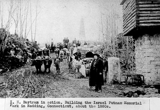
The
erection of the monument occupied the attention of the park
commissioners during 1888 (Bartram et al. 1889: 43-44). Immediately
thereafter, work began on the construction of the park entrances,
roads, bridges, and other features. Most of the area was wooded
and overgrown when the park was created. According to the
1887 legislative committee's report, "a fine forest covers
the greater portion of the site" (Bartram 1887: 40-41).
The commissioners' report for 1889-90 describes the early
work in the park:
Active
work was begun at once in clearing under-brush and rock from
the grounds, building drives, walks, log-barracks, and block-houses.
We found the grounds rough and stubborn to clear. Much of
the timber had been cut, leaving large and obstinate stumps
to remove. We were forced to make many changes from the plans,
as were they followed out, it would mar the beauty of many
of the fine features of the camp, and come in contact with
the fire-backs. These changes were made only after a careful
consideration and by a vote of the Commission. (Report 1893:
51).
These
features--the antiquarian infrastructure of the park--were
described in the parlance of the time as "improvements."
The 1889 committee's report detailed some of the specific
plans that were underway in the park (Bartram et al. 1889:
46-47): estimates were prepared for the construction of a
main avenue (later called Putnam Avenue), side avenues, ways,
and paths; for the construction of block houses and gates
at the park's entrance; for the construction of a masonry
dam; for bridges, culverts, stone and iron fencing, and gates;
and for the building of "6 barracks with chimneys or
log huts in ye olden time of 1778, at $200 each."
One
of the most important activities during the early years of
the park was the clearing and landscaping of the terrain around
the stone piles that marked the remains of the soldiers' huts
during the encampment of 1778-79. While the park records make
it clear that the preservation of the firebacks and other
remains of the 1778-79 encampment was of paramount importance,
it is also clear from a review of the records, supplemented
by the evidence of archaeological testing, that the remains
of the original camp suffered a great deal of disturbance
from the methods that were employed by the early park to "restore"
them. These included grading, landscaping, and removing trees,
stumps, and stones, and it seems probable that most of the
firebacks (in the main double row along Putnam Avenue, at
least) were systematically cleaned out, their artifacts removed;
some were certainly rebuilt, including several in the vicinity
of the monument. The remains also suffered from the fact that
in several areas (the guard house, log barrack, and stone
barrack) modern reconstructions were built directly on top
of the original ruins.
It
is sufficient to point out here that Revolutionary War period
artifacts were regularly discovered and collected from the
site during these activities. We also learn from the inventory
of "relics" deposited in the park's museum that
many were collected by Thomas Delaney, who served for 24 years
as the park's first superintendent; in that capacity he was
in charge of much of the grading around the firebacks Among
the artifacts in the museum were:
Box
of Bullets and Grape Shot found on the grounds, donated by
Thomas Delaney.
Wood
with Bullets imbedded in it, found on the grounds, donated
by Thomas Delaney.
Old
Gun Barrel, found on grounds, donated by Thomas Delaney. (Todd
1913: 45)
The
network of roads and paths created in the first few years
of the park still exist today and serve to define the limits
of the main encampment. These roads, which were all named,
are shown on the 1890 plan; the park records (Report 1903:
11) list the principal roads and their names:
Putnam
Avenue, the main avenue through the middle of the grounds.
Overlook
Avenue. runs over Overlook Hill on the west side of the park.
Sustinet
Avenue, passes up the west side of Prospect Hill.
Terrace
Road, runs parallel with Sherman Avenue separated from it
by the retaining wall.
Sheldon
Avenue. connects the entrance. Putnam Avenue and Overlook
Avenue on the south.
Huntington
Avenue, connects Sustinet Avenue, Putnam Avenue and Overlook
Avenue on the north.
The
origin of the toponymy seems to be a mixture of historical
associations and topographical descriptions. Putnam, Huntington,
and Sheldon avenues were named for generals who were associated
with the encampment: Major General Israel Putnam, who commanded
the three brigades that wintered in Redding in 1778-79; Jedediah
Huntington, commander of the 2nd Connecticut Brigade; and
Elisha Sheldon, who commanded the state cavalry corps. (Sheldon
and his troops were mistakenly believed to have spent the
winter in Redding; in fact, they were stationed at Durham,
Connecticut). The origin of the name of Sustinet Avenue is
obscure, although it may have derived from the Connecticut
state motto, Qui transtulit sustinet ("He who has transplanted
will sustain"). Overlook and Terrace avenues were obviously
named for topographical features.
Also
built by the turn of the century were the main entrance to
the encampment, with its substantial stone bridge, blockhouses,
and gate posts; a "rustic bridge" and smaller blockhouses
at the north entrance to the camp, on the Sherman Turnpike
(Route 58); a pavilion (1893); horse sheds; a "work shop,"
moved to the park in 1896; and a "rustic arbor"
(Report 1903: 11).
Expansion
of the Park
The
park records indicate that, as early as the turn of the century,
the park commission had determined to acquire the grounds
of the "Old Put Club" on the east side of the main
encampment. This land was necessary, according to the commission,
for "the immediate and imperative need for the future
protection and development of the grounds into a suitable
memorial" (Report 1903: 12). The principal reasons are
described:
The
grounds are a part and parcel of the cantonment itself. It
is a part of the landscape picture and without it the grounds
will lack unity of design and purpose. It belongs to it and
is needed by it as truly as the outside of the house is needed
by the rooms inside.
It
will enable all the work shops, shed, and houses for domestic
use to be off those grounds which an peculiarly sacred for
association sake, and the swings, animals and birds which
have been presented to the State and are of interest to the
children to be moved away from amongst the relics of the camp.
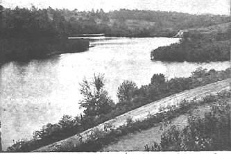
The
possession of "Old Put Lake" is in every way desirable
for the camp grounds, it is one of the most beautiful sheets
of water in Western Connecticut, lying just over the eastern
boundary line of the park and for quite a distance is less
than one hundred feet from it. (Report 1903: 12-13)
As
the description indicates, the park commissioners envisioned
a fundamental separation of the park into two areas: one,
on the west side, preserving the historical remains of the
encampment, and the other, on the east side, offering recreational
and scenic resources. This functional division of the park
has remained to the present.
Despite
the attempts of the commissioners to convince the state legislature
to purchase the grounds of the "Old Put Club," it
was not until 1923 that the state finally acquired the land
on behalf of the park. Surveyed maps of the areas east of
Route 58 were made in 1907 and 1923, and show various features
and structures on the property (see Figs. 40, 41). The 1924
sketch plan shows the park with its modem outlines (Plan 3).
In addition to the former "Old Put Club" grounds,
additional new lands were acquired west of the original park
grounds; a comparison of the park boundaries on the 1890 and
1924 plans shows how much new land was obtained for the park
by the 1920s (see Plans 1, 3).
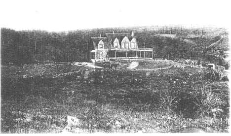
The
east side of the park includes Lake Putnam, formed ca. 1891
by damming the course of the Little River; several picnic
grounds; the Park Manager's House, a 1925 Colonial Revival
residence built on the site of the 1891 clubhouse of the Old
Put Club, and apparently incorporating some of its structural
elements; the park's maintenance garage, a Dutch Colonial
fieldstone barn built in 1912; other former structures, including
toilets, a shelter, and icehouse; and the site of an isolated
group of possible firebacks.
Meanwhile,
on the west side of Route 58, several new structures were
constructed in the 1920s. They included two buildings on Prospect
Hill: the Colonial Revival museum, built in 1921, and the
Park Ranger's House, a ca. 1925 Craftsman bungalow built on
the south side of the hill to replace a former residence.
Also by this time the so-failed "middle entrance"
to the park, connecting the south end of Prospect Hill with
the Sherman Turnpike (Route 58), had been built.
In
1955 the state legislature voted to give control of the Israel
Putnam Memorial Campground to the state's Park and Forest
Commission. Today, the Putnam Memorial State Park is managed
by the Department of Environmental Protection, Office of Parks
and Recreation. For several years prior to the survey park
activities had been limited to part-time maintenance carried
out by a resident park manager and his assistant. By 1993
this was limited to occasional visits by a regional supervisor.
The
Old Put Club
From an short write up found in the Putnam Park Folder
at the Mark Twain Library. *If anyone knows who the author
is please drop me an e-mail.
Adjoining
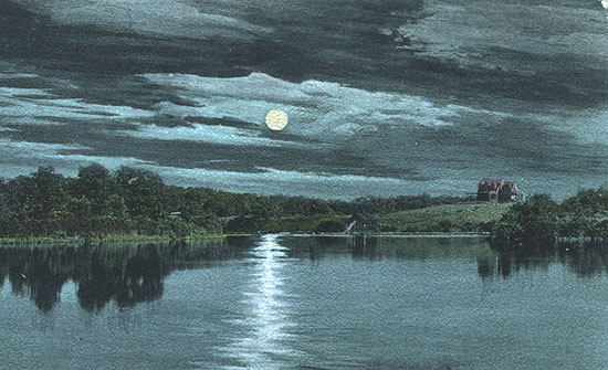
the park proper on the east beyond the State road is its latest
and most important addition -- a beautiful lake with dark
wooded heights rising beyond -- the former holdings of the
Old Put Club, which was formed the year after the park was
opened, 1891, by several gentlemen of Danbury and Bethel --
Frank Judd, Samuel S. Ambler, George M. Cole, William Benedict,
Theodore Ferry, Judge Hough and others, for the purpose of
building a dam across Little River to impound its waters and
create the beautiful lake we now behold. Its present bed was
then a swamp of alders, willows, sedge and other aquatic plants
through which flowed sluggishly the "' river, having
just been formed by the three brooks that flow down the parkside
from the west, and a larger one coming from the north along
the Bethel road. The site was chosen and the dam built by
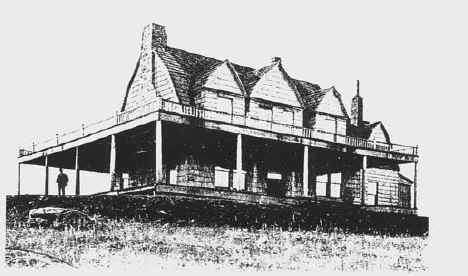
Isaac M. Bartram, and a clubhouse and keeper's dwelling was
added soon after.
For
many years the Club flourished -- at one time, Mr. Frank Judd
informs me, it had fifty members, but some died or moved away,
others dropped out and at last it became necessary to sell
and wind up its affairs; it was accordingly sold to the Rogers
Peet Company of New York and for several seasons was used
by them as a summer vacation resort for their clerks and other
employees. The State acquired it in 1923. Its area is 103
acres -- greater than that on the west which is 102.
We
will now return to the Main Entrance and complete our tour
of the grounds. Passing the Superintendent's modern cottage
-- the former Clubhouse burned a few years ago and the State
replaced it with this much finer structure. A short distance
south, nearly opposite the store, we make a sharp turn east,
go down below the dam and on rising turn sharp north where
is a new road opened by the State since it acquired possession,
running up over the wooded heights and regaining the State
road near the North Entrance of the park. There are rocks
and boulders on the hillside and a dense forest over all shutting
out even a glimmer of the lake. The Commission hopes to open
lanes and vistas through it this summer permitting its cheerful
sparkling waters to greet the visitor.
At
the summit we will find eighteen stone heaps similar to those
across the lake but not arranged in parallel rows more in
squares circles and triangles -- an outpost of the main body
no doubt set here to guard against attack from the east and
south.
Continuing
on down the hill, still west, we come soon to a rough woods
road leading left over a slight rise and down to the lakeside
by the former summer camp of the Rogers Peet boys, now sometimes
used for banquets and dancing parties. A few hundred yards
farther on, crossing the brook as it enters the lake, we regain
the State road near the Northern or Bethel Entrance to the
park.
Most
Recent Park Improvements
By
the 1970's and 80's park attendance was diminishing, buildings
fell into disrepair and the park was officially decommissioned
& closed when State Parks' operating budgets were pared back
in the early 1990's. A small group of neighbors and local
supporters volunteered to physically maintain the park the
best they could from 1991 to 1997. 1997 was the year the park
was reopened, due largely to the persistent efforts of the
Friends and Neighbors of Putnam Park (FANs) who lobbied the
DEP in Hartford for staffing and funding.
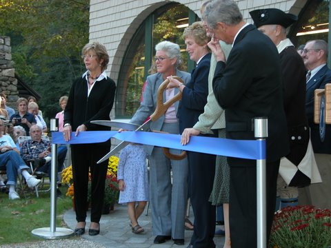
On
the heels of their success in reopening the park, the Friends
and Neighbors of Putnam Park hired a restoration consultant
to offer an opinion of whether or not the park's 1893 pavilion
could be saved. The consultant said "Save the pavilion!".
Next the DEP State Parks Division worked with architects to
retrofit the Old 1893 Pavilion into a modern day visitor center.
The old structure was dismantled piece by piece, beam by beam,
and numbered. A new foundation was excavated for a new walk-out
cellar level. Then the building was reconstructed using materials
that were still sound. Today the new visitor center is a all
climate-controlled building with rest rooms. The very expensive
project included a new and safer Rt. 107/Rt. 58 intersection,
new parking lot, and a new main entrance into the park. The
visitor center grand opening was held on October 11, 2005.
Putnam
Memorial State Park in Redding has been designated as Connecticut's
first State Archaeological Preserve. The designation, bestowed
by the Connecticut Historical Commission, recognizes the archaeological
importance of Putnam Memorial State Park and provides additional
administrative measures for the park's protection and professional
management. The "Friends and Neighbors of Putnam Memorial
State Park" (FANs) initially requested the designation. It
was later endorsed by DEP Commissioner Rocque and was officially
designated a State Archaeological Preserve on January 3, 2001.
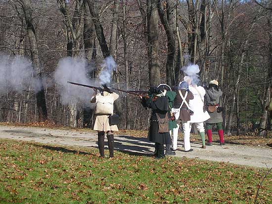
Putnam
Memorial State Park hosts many, many great learning programs
throughout the year and is well worth the trip. May is Living
History School Days month; The annual Summer Craftsman Program
runs 8 weeks in July and August; Living History Weekend complete
with mock battle skirmishes is held in the Fall; the annual
Winter Walk is always informative and held in December.
Museum:
The building contains exhibits and historical material related
to Redding's encampments. Open 11am to 5pm daily, Memorial
Day thru Columbus Day.
Group
Tour Reservations: 203-938-2285.
Park
is Open: Daily- 8am to sunset.
Photo
Tour of Putnam Park (PDF)
Photos
of Putnam Park- that relate to My Brother Sam is Dead
Friends
and Neighbors (FANs) of Putnam Park Web Site
Connecticut
Revolutionary War Re-enactment Regiments

Back to TOP
| Back to Redding Section | Back
to Georgetown Section
|