|
Quick
Link: Pictures of Branchville
; DeBenigno's
Store ; Branchville in the News
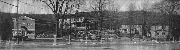
What the corner
of Route 7 and Route 102 used to look like.
Ancona's
Market celebrates 87 years of memories
From
"Branchville's Birth" by Jack Sanders December 30,
1986.
Branchville, first
applied in 1870 to the southeast corner of town(Ridgefield),
was named for the "branch" rail line from the Danbury
and Norwalk Railroad to Ridgefield Village. The first recorded
use of the term appears in an 1870 deed for four acres "lying
in the town of Ridgefield at Branchville."
It was the very
same year that the branch line was built, suggesting that
the railroad rather than neighborhood residents had invented
the name to distinguish the station from the new one at Ridgefield
center. Previously, the station at Branchville had been known
as Ridgefield Station.
Passenger service
on the branch line was available into town until 1925; freight
service lasted until 1964. Most of the trackbed, complete
with gravel but missing its rails, is today the path of the
Northeast Utilities high voltage line. Some of the other sections
along southern Florida Road have been sold to adjoining landowners.
To the Indians,
the southeast corner of town was known as Wheer Cock. Later
it was called Copps Corner. When the railroad line from Norwalk
to Danbury was completed in 1852, the neighborhood was at
first called Beers Station or Ridgefield Station, after the
stop there.
While this area
had been mostly farmland and a mill or two, the coming of
the railroad sparking the development of a booming, albeit
small-scale, industrial community. It included mills, stores,
a hotel, a machinery factory, a noted mineral quarry, a post
office, and a school (the schoolhouse, still standing on Old
Branchville Road, has in recent years been used by the Jaycees
as a meeting hall).
Branchville had
its own school district at own school district at least since
the middle 19th Century-it was known as the "Ridgefield
Station District" before it was called Branchville. Its
schoolhouse was used until around 1927 when children started
being "bused" to Garden School on Bailey Avenue
in the village. A new Branchville School opened in 1969 on
lower Florida Road, remained in use until 1983 when it was
closed due to declining enrollments.
An 1893 atlas labels
this territory as "Plattsville," which is undoubtedly
a mapmaker's error. The U.S. Geological Survey map uses "Branchville
Hill" for the ridge along Old Branchville Road at Bruschi
Lane.
A map prepared
for the town assessors in 1934 labels as Branchville Hill
road what we today call Nod Hill Road. This suggest that the
ridge traversed by this road was at some time called Branchville
Hill, a more likely possibility than the Branchville Hill
situation cited above.
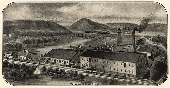
Railroads Influence
on Branchville/Georgetown area
By Brent M. Colley
By the mid-to-late
1870's, The D&N was competing against several other companies
including the New York, New Haven & Hartford and the Housatonic
Railroad. The D&N sought an advantage in freight traffic by
building a rail and ferry connection on Long Island Sound
at Wilson's Point in South Norwalk in 1882. That extension
of the transportation system allowed for an excellent intermodal
connection between steamships and freight cars ready to move
goods inland or ship raw materials like ice, quarried stone,
and wire products to the ports of New York City.
The Wilson Point
extension proved to be very profitable for the D&N and made
the D&N Railroad an attractive business partner for other
rail lines including the Housatonic Railroad and the New York,
New Haven & Hartford. The extension proved to be even more
profitable for the businesses located on the D&N rail line.
The timing could not have been better for the Gilbert & Bennett
Manufacturing Co., they had recently incorporated as a joint
stock company to overcome their losses via a fire that destroyed
their upper factories and now as a result of the RR expansion
had direct access to worldwide ports, not to mention a spur
line running directly into their warehouses. Branchville businesses
profited as well
the discoveries at Fillow's Mine attracted
businesses and geologists from far and wide to create a local
mining industry that would continue into the 1940's. The Union
Porcelain Works of Greenpoint, New York was the first to arrive
in 1880 to mine for quartz and feldspar and as a result of
the RR expansion had instant access to a booming freight line.
Ridgefield Granite Works, that we'll discuss below, had been
in business since the initial RR line was laid and now had
access to larger markets as well.
And as we all know
the success of businesses, creates jobs and attracts employees
employees
have families, families have needs and therefore with the
next wave came the businesses that "service" these needs.
In almost "textbook" fashion the towns of Branchville and
Georgetown flourished with the introduction and improvements
of the D&N railroad.
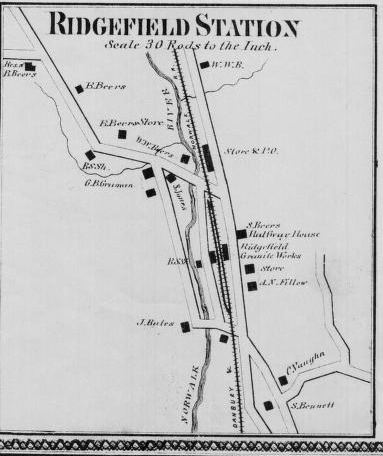
Ridgefield/Branchville
Station in the 1850's
The
Branchville Mine & The Mining History of Branchville:
by Brent M. Colley (Mining
Document if you missed the Mining Tour in May)
Abijiha
N. Fillow's Branchville Mica Mine was by-far the "magnetic
force" that attracted mining companies and geologists to the
area. However, as the map above shows 20 years prior to the
discoveries at Fillow's mine, Philo Bates' Ridgefield Granite
Works was operating out of the station area. In land records
regarding properties on Mountain Rd., Philo W. Bates is listed
in 1875 as owning land "East" of 32 Mountain Rd. and in 1890
as conveying a 20 acre parcel to Abijiha Fillow at 34 Mountain
Rd. which would place at least a portion of his mining areas
on Mountain Rd. and in the areas of the Scott Preserve/Rock
Lot.
Little
is known about the Ridgefield Granite Works aside from the
1856 Clark's Map reference and land records of properties
owned by Philo W. Bates but it is presumed that it was a successful
business given the span of time it operated in the area. Also
appearing on the 1856 station map as a business is Walter
Bates, mason and builder, which very likely involved a joint-venture
with the Granite Works.
The
"World Famous" Branchville Mica mine lies in the town of Redding
on Mountain Road, 550 ft. N.E. of the Branchville railroad
station.
The
first excavation in the Branchville Mine was made about 1876
by Abijiha N. Fillow, then owner of the property. Fillow was
mining for mica. The mica recovered was then considered of
inferior quality, and operations ceased sometime before the
spring of 1878. At that time, George J. Brush and Edward S.
Dana, both of Yale University, became so enthused about the
new minerals at Branchville that they engaged Fillow to excavate
the deposit with funds furnished by Yale.
The
results of these excavations gained the mine worldwide fame
as (9) rare minerals (eight were discovered for the first
time in the history of science) were mined at this unique
location:
(A)
Lithiophilite, maganese-iron phosphate, its name indicates
its lithium content.
(B) Natrophilite, sodium-manganese phosphate, its name indicates
a high sodium content.
(C) Dickinsonite, hydrated acid phosphate of sodium and manganese.
Named in honor of Rev. Dickinson, formerly of Redding, CT.
(D) Fillowite, a hydrated acid phosphate of sodium, manganese,
iron and calcium. Named in honor of A.N. Fillow of Branchville,
CT
(E) Fairfieldite, a hydrated phosphate of calcium. Named in
honor of Fairfield, CT
(F) Eosphorite, a hydrated basis phosphate of aluminum with
iron and manganese. Named from the Greek in allusion to its
pink color.
(G) Reddingite, hydrated phosphate of manganese and iron.
Named in honor of Redding township.
(H) Tripoidite, basis phosphate of manganese and iron. Named
in allusion to its resemblance to triplite in physical character
and composition.
Information
regarding these minerals appeared in scientific journals from
1878 to 1890 launching Brush and Dana's careers and one would
hope- Fillow's real estate property value.
The World
Famous Branchville Mica Mine Today (2006)
In
1880 the Union Porcelain Works of Greenpoint, New York, bought
the property from Fillow and operated it for feldspar and
quartz until 1891. The principal use for feldspar was in the
ceramic industry. Other uses included enameling for metal,
glazes, and abrasives in soaps. At this time the mine was
renamed "The Smith Mine". Fillow stayed on as supervisor of
mining operations but resigned one year later. As a stipulation
in the sale, all unused minerals were to be placed at the
disposal of Brush and Dana.
Next
the Bridgeport Wood Finishing
Company of Bridgeport & later New Milford, Connecticut,
operated for quartz and feldspar at the mine as well as other
locations in the Branchville area from 1891 to 1917. These
"other" areas included Mountain Rd., Pine Mountain Rd. and
parts of the land we now refer to as the Scott Preserve/Rock
Lot. Deeds indicate Jesse Fillow leased a 3-acre triangular
piece to the BWFC at 32 Mountain Rd. in 1911, BWFC transferred
it to Gininone Di Giavanni in 1914. BWFC also leased a 4-acre
tract from John Barrett in 1911 at 34 Mountain Rd. for "the
purpose of searching for quartz or silica; of conducting mining
and quarrying operations and of recovering from here any quartz
or silica
" Details also note "BWFC has the right to renew
this agreement on the same terms and conditions for a further
period of 10 years upon written notice..." the mining operation
called for the removal of 100 gross tons of quartz or silica.
More specifically "if 100 gross tons of quartz or silica are
not mined or quarried, as now contemplated by said parties
within any year during the continuance of this agreement
then
these presents and everything contained therein shall cease
and be forever null and void."
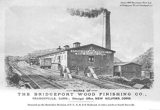
In
1906, historian Charles Burr Todd wrote: "There is
a large frame building standing just across the track from
the quarry on the line of the branch road leading to Ridgefield.
This building...has been erected and furnished with powerful
and costly machinery for the purpose of crushing the quartz,
or, more properly, oxide of silicon, found in the neighboring
hills..."
"Silex"
was the trade name for quartz sand, a form of silica BWFC
used extensively in making paste wood fillers; it is chemically
inert, does not absorb moisture or shrink and can be stained
to match any finish. Unfortunately for its workers it was
also extremely damaging to the lungs. BWFC was in business
from 1876 to 1917 when it was purchased by DuPont.
In
addition to Bridgeport Wood Finishing Co. the properties in
and around the mine were leased to several other individuals
and companies in this time frame. For example, a June of 1897
lease between BWFC and William Haaker for 65 acres of land
in Redding and Ridgefield, provided BWFC the right to mine
for quartz and feldspar, and specifically stated that Haaker
only had the right to quarry granite. In 1907 Haaker leased
the same parcel to Traylor Manufacturing and Mining Co. of
New Jersey for the purpose of mining quartz and feldspar for
a period of 5 years. In 1914, Anna Haaker leased the same
parcel to Monarch Mining Co, formerly Traylor Manufacturing
and Mining Company. Traylor Manufacturing and Mining Company
incorporated in 1907 with capital stock of $20,000 and one
year later would increase that stock to $50,000 and change
their name to Monarch Mining Company.
J.
Frank Schairer located 31 different minerals at the mine in
1926. It was part of his research work on "The Minerals of
Connecticut." He collected the data while he was at Yale.
From
September 1943 to November 1944, Fred and Joseph Burrone and
Carlo Rusconi, all of North Branford, Connecticut, operated
the mine for mica, and the Sandy Ridge Mica and Mining Company,
Inc., 927 15th Street N. W., Washington, D. C., worked the
mine in November and December 1944. Also in 1944, detailed
studies of the geology were made as part of the strategic-minerals
investigations of the United States Geological Survey.
Sheet
and scrap were the two types of mica mined. Sheet mica was
used primarily for insulating electrical equipment. Specifically
it was used in spark plugs, lamp sockets, radio apparatus,
fuse boxes, heating devices and telephones.
Scrap
mica was used for roofing, wallpaper, paints, for filler in
rubber such as automobile tires, and lubricants. The demand
for sheet mica during World War II induced operators to work
the long dormant mine in 1943 and 1944.
After1944
the mine was sporadically operated until 1954.
The
last attempt to reopen the mine was made in 1979 by geologist,
Michael DeLuca but his request was turned down by the zoning
commission.
About
Mica:
The
word "mica" is thought to be derived from the Latin word micare,
meaning to shine, in reference to the brilliant appearance
of this mineral (especially when in small scales).
Mica
is found abundantly throughout Asia, Africa, as well as North
and South America. Until the 19th century, mica was quite
rare and expensive as a result of the limited supply in Europe.
However, its price dramatically dropped when large reserves
were found and mined in Africa and South America after the
early 19th century.
Mica
has a high dielectric strength and excellent chemical stability,
making it a favored material for manufacturing capacitors
for radio frequency applications. It has also been used as
an insulator in high voltage electrical equipment.
Specific
varieties of mica include:
- Biotite
- Muscovite
- Lepidolite
- Phlogopite
Mica is a general
term for a large group of minerals, hydrous silicates of aluminum
and potassium, often containing magnesium, ferrous iron, ferric
iron, sodium, and lithium and more rarely containing barium,
chromium, and fluorine. All crystallize in the monoclinic
system, but mica is most commonly found in the form of scales
and sheets. All the micas have an excellent basal cleavage,
splitting into very thin, elastic laminae. Some varieties
are transparent; resistance to heat is high.
Commercially, the
most important micas are muscovite (potassium mica) and phlogopite
(magnesium mica).
Muscovite, the
commoner variety, is usually colorless, but it may be red,
yellow, green, brown, or gray, with a vitreous to pearly luster.
It occurs in granites, syenites, mica schists, and gneisses,
but is most common in pegmatite dikes. It is widely distributed.
Phlogopite varies
in color from yellow to brown, some specimens having a coppery
tint and others being greenish. It occurs in crystalline limestones,
dolomites, and serpentines in Canada, New York, New Jersey,
and Finland.
Mica mining, because
of the necessity of keeping the crystals intact, is a delicate
operation; drills and blasting powder must be used carefully,
if at all. The mined crystals are first cobbed, i.e., roughly
trimmed of rock and cut, then split with a hammer into plates,
and further split into sheets with a knife.
Sheet mica is used
as an insulating material and as a resonant diaphragm in certain
acoustical devices.
Scrap and ground
mica is used in wallpaper, fancy paint, ornamental tile, roofing,
lubricating oil, and Christmas-tree snow.
Ground mica is
sometimes pressed into sheets (micanite) that can be used
as sheet mica.
Most of the sheet
mica used in the United States is imported, chiefly from India
and also from Brazil. Synthetic mica was produced in the United
States after intensive government-sponsored research began
in 1946.
About Granite
Granite is the
name used for a variety of light-colored, coarse-grained igneous
rocks. Orthoclase (potassium) feldspar is typically the most
abundant mineral in granite and significant amounts of quartz
and plagioclase feldspar are generally present as well. Minor
minerals include muscovite mica, biotite mica, hornblende
and others.
The coarse grain
size of granite indicates a slow rate of cooling that occurred
below the earth's surface. The insulating effect of the surrounding
rock caused the magma to crystallize very slowly. The slow
cooling allowed the mineral grains adequate time to grow to
a large size.
Because it crystallizes
"at depth" Granite exposed at the surface indicates a location
where deep erosion has taken place.
Granite is a very
strong, durable stone and is used in a variety of ways. Its
attractive appearance makes it useful as an architectural
stone. It is also widely used in monuments, grave markers,
stair treads, counter tops, window sills, street curbing and
other dimension stone uses.
Granite is also
used in the form of crushed stone or aggregate. Granite aggregate
is mainly used for road construction and maintenance, however
there are many other uses which include concrete, landscaping
stone and paving. The U.S. Geological Survey estimates that
granite accounts for about 16% of the United States crushed
stone production, behind limestone and dolomite.
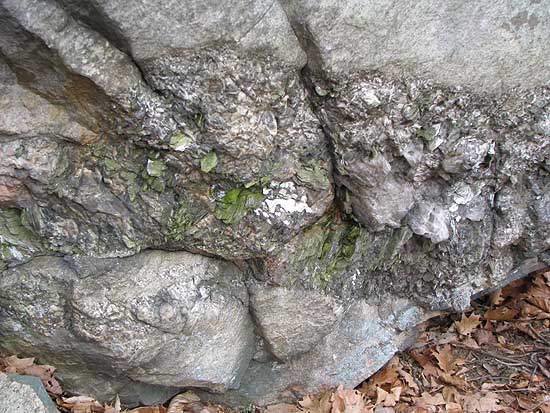
What Created
The Mining Scars Found on Granite Rocks in and around Branchville?
Hand drilling was
the method used by quarry miners to extract granite blocks
from the landscape. Hand drilling helps remove rock three
ways: (1) A rock may be split into chunks of manageable size
by steel drilled into a natural seam; (2) If the steel in
the seam does not split the rock by itself, the hole may be
fitted with the wedge and feathers. The wedge is driven between
the feathers with a hammer until the rock breaks; (3) Finally
a hole may be used to prepare a rock for blasting. In general,
the larger the rocks, the more likely you will use explosives
to move them. Although hand drilling was slow work, it was
a safe and simple way to chisel out granite blocks and/or
prepare the rocks for blasting.
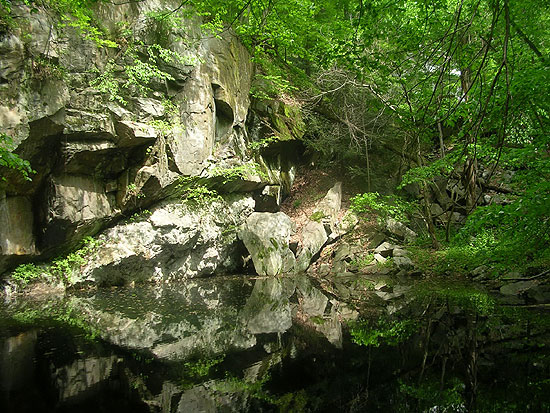
Old drill holes
are now filled with moss (middle of photo along crack)
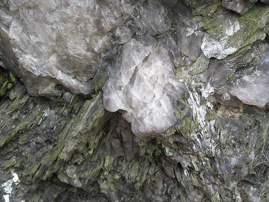
The driller drives
the steel by methodical hammering and turning. When the hammer
strikes the head of the steel, the bit is forced against the
rock. After each blow of the hammer, the driller turns the
steel slightly and strikes it again. With each blow the bit
chips small amounts of rock that collect in the hole as "drilling
dust." The driller removes the dust by adding water to the
hole, which creates a mud that sticks to the sides of the
steel. To clear the mud, the driller removes the steel and
raps it against the rock. The procedure is continued until
the hole is deep enough; longer steel is substituted as the
hole lengthens.
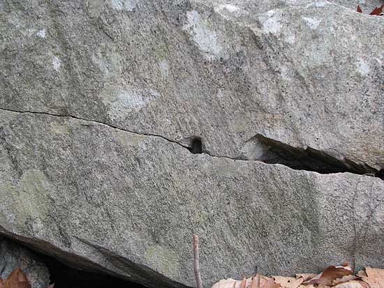
Lone drill hole
with another one started to the left of it.
The steel is manipulated
with one hand while the other hand hammers (single jacking),
or the steel is manipulated by two hands while another person
hammers (double jacking).
Ambidexterity was
very helpful for the single jack driller because he could
work longer by shifting the hammer from one hand to the other
to distribute the work. In double jacking one or two drillers
hit a drilling steel with large sledge hammers while a holder
turned the steel slightly after each blow. As the hole deepened,
the holder substituted longer steels in a way that did not
interrupt the driller's disciplined rhythm.
Random
Notes on Branchville
Sherman
Beers was paid $600 for the right to cross land by the DNRR
1850. Not bad, most others received from $1 to $100. Beers
family major land owners in Ridgefield/Branchville area. 252
acres at one time.
Ridgefield
or Beers Station originally. Branchline run in 1869-70 resulted
in name change. A train ran up to Branchville several days
(Feb. 22, 1852) before first official train from Norwalk to
Danbury ran on March 1, 1852.
Before
Branchline people were transported to Ridgefield in horse
and buggy. Branch closed to passengers 1925 (cars, highway
improvements), freight 1964, never electrified. Walking trail
now. NU utility lines.
Old
names for Branchville's location: Wheer
Cock, Copps Corner (John Copp, original
surveyor of Ridgefield 1707-08) Beer's Station, Ridgefield
Station.
Comical
story relayed by Jack
Sanders
Branchvillers tried to pull a "switch-a-roo" on
Ridgefield. Signs were created and posted naming Branchville
as Ridgefield and the actual town of Ridgefield as "West Ridgefield"
This did not go over big and lasted a very short time.
West
Branchville Road, is actually Eastern most point of Ridgefield.
At one time Main Street. The name is puzzling to say the least.
Notable
Individuals:
Julian
Alden Weir. Old Beers Farm. 250+ paintings in Branchville.
National Historic Site. Founding member of 10 American painters.
Property retreat for famous artists of the time period. House
enlarged by famous architect Stanford White.
John
Ames Mitchell, Life Magazine, Life's Fresh Air Camp. City
children came for summer get aways. Later Hidden Valley, Branchville
School Location.
Branchville
to Topstone Stretch
Couch's
cut. The Section between Branchville and Topstone was a very
difficult stretch for railworkers. There was quite a bit of
rock to get through and dynamite was about 18 yrs from being
invented. Pick axes and black powder were likely used. Thomas
Couch was a partner in the 19th Century iron foundry at the
north corner of Florida Hill Road and Route 7. Couch's cut
comes from his name.
The
foundry, which received pig iron from Norwalk and turned it
into agricultural tools, sleigh shoes, stoves, and all kinds
of metal parts. The foundry, which operated in the middle
and late 19th Century, was on the site of an old grist and
saw mill . The grist mill had been erected around 1737 by
Peter Burr and had gone through many owners over the years:
One was a Thomas Couch and his wife, Sara, who owned it from
1783 to 1818. Along with his partner, Ebenezer Burr Sanford,
Thomas N. Couch, possibly the elder Couches' son or grandson,
acquired the grist and saw mills around 1831.
When
the foundry was established is not known. There is tradition
that during the Civil War Couch and Sanford configured a cannon
and fired it whenever good news came back from the battlefield.
Ridgefield's
Surveyor: John Copp (1673-1751)
Colonial Jack of All Trades
by Silvio A. Bedini
In
reading about colonial American surveyors, it is apparent
that few if any were professionally trained. For the most
part they were self-taught and pursued other community activities
in addition to surveying, generally a common trade ranging
from farming to shoemaking. An exception was John Copp of
Boston, who fulfilled numerous civic responsibilities not
only in one community, but in two, as well as in his state.
Born in 1673, he was the son of David Copp, one of William
Copps nine children and a cordwainer like his father. William
Copp had emigrated from England. David expanded the cordwainer
business, was the ruling elder of the First Church, clerk
of the market, and sealer of leather. He was a surveyor and
adviser to the Boston selectmen on various matters including
laying of bounds for highways and property listings in the
town. David also was designated by the selectmen to cooperate
with the constable in the suppression of excessive drinking
and disorders in private houses and licensed places of entertainment.
He was a highly esteemed citizen and bearer at funerals of
the old elite of old Boston, and among his friends was the
Reverend Cottom Mather.
Established
in Many Professions
His
son John Copp moved to Connecticut while in his twenties,
and in 1698 he married the widow Mary Jagger Phelps of Stamford.
Apparently, not long thereafter he was widowed, then married
again three years later to another widow. There were no children
from either marriage.
During
the next few years Copp apparently established himself as
a schoolteacher in Stamford with success, for his name next
appeared in Norwalk in 1701 when a town meeting voted to hire
him as schoolmaster in case he can be obtained. The meeting
left the salary open to negotiation of reasonable termes
but specified that part of the payment in the amount of 1
pound 55 should come from a tuition charged to the schollers
(pupils) with the payment divided equally among them. Copp
accepted the position and taught both day and evening classes.
In
addition to schoolteacher, Copp was also the local medical
doctor. In 1705 he obtained the recommendation of the selectmen
of Norwalk and applied for a license to practise medicine.
He was granted a license, and in 1710 or 1711 he was appointed
a surgeon with a Connecticut regiment which was to march to
Port Royal in Canada to engage the French in battle. At a
meeting of the Governors Council in New Haven held on July
24, 1711, it was ordered that a letter be dispatched to Copp
desiring him to attend and go as Doctor in the expedition
against Canada, which letter was drawn and sent accordingly.
Copp was to be paid six pounds a month for his service out
of the Colony treasury and that he shall have a suit of the
regimental cloaths, gratis. If and where and when Copp received
medical training is not known.
Copp
had been trained in surveying by his father, and probably
had accompanied him on some of his field work, and from time
to time engaged in surveying when called upon. When as early
as 1697 Norwalk residents began to become interested in land
to the north of their community which was owned by Indians,
Copp frequently was called upon to survey for members of the
community. The land was high and rocky, but the soil was fertile
and there were more than sixty miles of streams that could
serve future mills. In 1706 and again two years later, he
was asked with others to survey land in the region, but various
difficulties arose and the expeditions resulted in failure.
The
First Purchase
Finally,
working alone in the summer of 1708, Copp managed to draw
up boundaries for a tract of land of 20,000 acres, roughly
in the southern half of the present town of Ridgefield. He
reported back to the Norwalk residents that we went up to
view said tract of land and upon our diligent endeavour for
a discovery, we find it to be accomodated with upland considerably
good and for quantity sufficient for thirty families, and
as for meadow land it surpasses both in quantity as well as
in quality what is common to be found in larger plantations.
In September, Copp and two others from Norwalk representing
the first 26 settlers of new community to be named Ridgfield
(later changed to Ridgefield) paid the Indians £100 sterling
for what was called the first purchase of which there were
to be seven more. The purchase having been made, the General
Assembly in session at Hartford in May 1709 appointed Major
Peter Burr of Fairfield, John Copp of Norwalk, and Josiah
Starr of Danbury, to serve as a committee to make a survey
of the tract of land and to lay it out for a town plat, and
to make return to the General Assembly at New Haven in the
following October of their doings therein, and of their opinion
how many inhabitants the said tract of land may admit and
contain. After this was done, a grant was made by the General
Assembly in session at New Haven on October 13, 1709.
Copp
was elected recorder or town clerk of the first town meeting
in 1709 and of which his notes of the meeting survive. Although
for a short time in 1714 Copp held title to property in the
new community, he did not hold title to property in the town.
In 1714 he had some land deeded to him which he turned over
to another several months later; it appears that he was acting
merely as a trustee.
During
the first several years of Ridgfields settlement, Copp apparently
lived with one pioneer family or another for periods ranging
from days to months at a time while he helped to lay out the
town and its main street. It was to be six rods wide, and
to run north and south along the eastern declivity of the
ridge. On either side of the street, home lots of two-and-one-half
acres were laid out, and in the rear of these, additional
lots of five acres, making a total of seven-and- one-half
acres. Subsequent divisions were made of the plough land,
meadow land, and bogs.
Haphazard
Schooling
Copp
also served as the towns physician, and as its first schoolmaster,
instructing the children in a small meeting house near the
center of the town. Schooling appears to have been somewhat
haphazard because Copp also had responsibilities in Norwalk
during this period, and it was not until 1721 that the subject
of education was mentioned in the town records. Ridgfields
first town meetings were probably held in Norwalk until the
settlement became more permanent and populated. Copp was also
the town clerk for Norwalk from 1708 to 1740. It is likely
that Copps records of Ridgfield town meetings were compiled
in Norwalk, his last entry made in 1713, when he was succeeded
as both recorder and schoolmaster by the Reverend Thomas Hauley,
the towns first minister.
The
settlement of Ridgfield was but one of Copps endeavors, for
during the same period he was extremely active in the civic
and ecclesiastical life of Norwalk and of Fairfield County
as well. In 1706, 1716, and 1718-19 he was elected state representative
from Norwalk to the Connecticut General Assembly. In 1711
he was appointed county surveyor and at the governors request
he assisted with a 1716 survey to determine the boundary between
Connecticut and New York State. In 1719 he was engaged in
clearing up confusion over the boundaries of the community
of Norwalk. In 1726 he was appointed to a town committee to
present grievances to county officials. Copp also surveyed
the town of Bradford, New York.
Copp
was no less active in Norwalks ecclesiastical affairs. He
was a deacon in Norwalks First Congregational Church, and
the town records note that in 1723 he was granted a position
of importance, the second pue [sic] from the pulpitt. His
wife was placed in the third pue on the womens side. During
the mid 1720s, Copp served on several church committees that
attempted to settle a dispute between the minister and his
parishioners, who were then most of the townspeople. The dispute
became so heated that in 1726 it was voted at the town meeting
to discontinue payment to the minister of his salary. Copps
name appeared on the records of Ridgfield in 1739, noting
that he had come to town to attend the installation of the
new Congregational minister, Jonathan Ingersoll, who came
to replace Thomas Hauley, who had died the year before.
In
his will drawn up in 1749, Copp freed his two slaves, Jack
and Sarah, and provided them with support. Copp died on May
16, 1751, at the age of seventy-eight. There are few suitable
memorials to John Copp in either community in which he lived
and worked. Copps Mountain, a name first used in the town
deed of 1721, was given to a ridge in the northern part of
Ridgefield. Along the southern end of this ridge is Settlers
Rock, campsite of the scouting party that set out to survey
Ridgefield in 1708 before the first purchase was made from
the Indians. Of later date, occurring in deeds from 1748,
is Copps Old Line referring to the border between Danbury
and Ridgefield, also Copps Corner in the Branchville section
referring to the boundaries of Ridgefield, Redding and Wilton
at the corner of Mountain Rd. and Peaceable St.
Silvio
Bedini was an Historian Emeritus with the Smithsonian Institution
in Washington, D.C., and a Contributing Editor for the magazine.
Branchville
Making News: Ancona's Market:
2007:
Ancona's Market celebrates 87 years of memories
2006:
Fruits of their labor: Third generation keeps family business
thriving
By BOB CHUVALA | Fairfield
County Business Journal
It
may not seem very old when put alongside Ridgefields 300-year
history, but at 86 years and now in its third generation,
Anconas Market is the towns oldest family-run business.
Actually,
thats quite an accomplishment because only 30 percent of
family businesses make it to the second generation, said Priscilla
Cale, director of the Family Business Program at the University
of Connecticut in Storrs. UConn recently gave Anconas
Market a Family Business of the Year award for not only
surviving, but thriving over the past eight-plus decades.
My
father started in business about 1920 just 1,000 feet from
where we are now, said 62-year-old John Ancona who, with
his 73-year-old brother, Joseph, are second-generation owners
of the market in Ridgefields Branchville section. But like
many families, exact dates and details can be fuzzy. 1920
is the date were using, Ancona said of the founding.
The
senior Ancona immigrated here from Sicily with his father
and brothers shortly after the turn of the last century, working
in the local Gilbert & Bennett wire in World War I.
When
he came back he put enough money together to start a small
business, Ancona said -- a general store of sorts, with a
soda fountain, dry goods, groceries, even a gasoline pump
outside.
Ancona
and his three brothers and one sister lived over the store
as their father expanded his grocery business and holdings
and opened a liquor store.
In
1949 their father constructed a brick building to house a
hardware store; the building survives (The Video Cinema; H&R
Block), the business doesnt. The grocery business moved into
the building in 1960.
The
elder Ancona died in 1958, and the family business passed
to oldest sons Joseph, then 24, and Nano, then 26. For the
next several decades, the second generation operated the grocery
and liquor stores. Nano ran the liquor business and Joseph
and I concentrate on the grocery business, Ancona said.
Flexibility
and innovation
In
1980, both businesses moved into a new 24,000-square-foot
building the Anconas built on Branchville Road property adjacent
to the brick building that faces Route 7. Since then, we
put in some additional space, bumping out a bakery in 1983
or 1984, and putting on another addition in 1987, Ancona
said. Today, the store is about 30,000 square feet, half the
size of a contemporary supermarket like Stop&Shop.
The
late Nanos wife, Carol, and son, Mitchell, own and run the
liquor business, while Joe and I each have a child working
in the business, he said. Actually, he said, theyre not
children any more. His daughter, Gina, is 30; Joes son,
JR, is 43 or so.
What
caught UConns attention, however, is not the family history,
but how the family tailored the business to meet changing
times and tastes. The annual UConn award has five criteria,
Cale said -- success, positive family and business linkage,
multigenerational family involvement, contribution to the
community and industry, and innovative business practices
and strategies.
A
lot of family businesses sometimes find it hard to separate
themselves from what theyve done in the past, Cale said.
But the Anconas separated themselves from what was not working,
she said. The hardware store wasnt working, so they closed
that. And successful family businesses exploit their competitive
advantage of flexibility. The Anconas listen to their customers
and read the market, and they do that extremely well. The
family added a bakery and a kitchen, for example, before
anyone else did.
Back
in 1978 Anconas added a kitchen and started selling fried
chicken and baked ziti, Ancona said. Not too many other grocery
stores did that then, he said. The cooked meal offerings
continued to expand to include roast turkey and prime rib,
all the side dishes and, six months ago, pizza. We make
our own dough.
The
prepared meals menu continues to grow to meet demand. Everybodys
on the go these days, and time is very valuable to people,
Ancona said. Our prepared meals are as good or better than
they can make at home, and thats what they opt for.
Thats
the kind of innovation we look for, Cale said.
Succession
planning
The
Anconas have one more advantage in that they recognize something
else about family businesses.
Some
family businesses see succession planning as a transaction,
Cale said. Its not. Its a process and it takes a long time
to do. Its very difficult to transfer the knowledge about
how a business should be run.
Some
family businesses dont survive to subsequent generations
because of market conditions and the economy, others because
they dont have a competitive advantage, she said. But most
fail to survive because of a lack of planning, particularly
succession planning. And failure for family business to go
on to the second generation is the norm.
In
Connecticut there are about 90,000 family businesses, Cale
said. About 60 percent of all jobs are created by family
business, but only 30 percent of the businesses make it to
the second generation. Assuming a family business lasts one
generation or about 30 years, only 20 percent of the jobs
will survive the transition in those 30 years.
Thats
one of the things that makes Anconas Market so remarkable
-- its survival into the third generation as a thriving, growing
business with about 60 employees, half of them full time.
To be that long lasting is definitely a generational thing,
Ancona said. Were the second and third generations in house
now, and thats encouraging.
Read
more great Fairfield County business stories at: http://www.fairfieldcbj.com
Back
to TOP | Back to Redding
Section | Back to Georgetown
Section
|