|
The
following information was taken from: "Huntington
Park Means Much to Redding" By Frank W. Nye
Before
the Huntington property was given to the State of Connecticut
it was offered to Redding, and we shall enjoy it the most.
With the State bearing the cost of maintenance, we shall reap
the chief benefits without expense.
Already
indebted to the late Archer M., and to Anna Hyatt Huntington,
for a gift to the Mark Twain Library comparable to that of
Mark Twain himself, it was a lucky day for our town when the
Huntingtons, after giving away their 500-acre estate on Low
Thor to the Palisades Park Commission, found in Redding a
worthy successor to the Hudson River property and settled
here to live out their long and rewarding lives.
Like
Mark Twain, Redding was the place they chose in which to spend
their ultimate years, and like him, they have greatly enriched
our community by means of their good taste, quite as well
as through their generosity.
Both
in our town planning, and as a part of the new Danbury Planning
Region, Redding is most fortunate in having already, in Putnam
Park, one historic recreational area, and in being able to
look forward to an even more beautiful park when our state
takes over the greater part of the Huntington acres.
America
is awakening to the need to preserve unspoiled our open spaces
as one of our chief natural resources. Redding has more than
its share of such beautiful spots and with planning and zoning,
is now fully on the alert to hold and improve the gifts of
Nature.
With
our new interest in the conservation of beauty, I found growing
curiosity and concern as to the meaning of the Huntington
gift, and decided to go straight to Anna Hyatt Huntington
herself for more background and information. My interest was
especially keen because I had had the privilege of walking
over every part of the estate, and I found it far more delightful
than I had guessed.
The
high ground in the V between Sunset Hill Road and Newtown
Turnpike was known in Indian times as Wiantenuck. The local
authority on this region and the man to whom Mrs. Huntington
referred me for certain details, as the one through whom the
property was purchased, is near-octogenerian Howard R. Briscoe,
who lives about a mile north of the Huntingtons on Route 58
in Bethel. His still excellent memory goes back to earlier
owners.
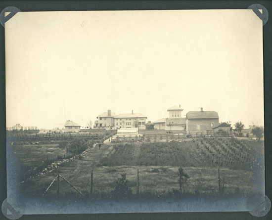
After
the house
burned down, the Huntingtons bought the property from the
estate of Mr. Sterrett, who had been president of Price, Waterhouse
& Co. Sterrett had picked it up at a comparative song
when Commandore Walther Luttgen, German partner of August
Belmont, died in 1922. Some of the Sterrett posting signs
are still in place.
But
it was Commodore
Luttgen who converted this beautiful land into a sylvan
paradise, with lakes and miles of Victorian carriage drives.
Luttgen, in turn, had bought the property from Senator Peck,
whose wife had been a Wells of Wells Fargo. (What with Pete
Adams family of Adams Express and the Wellses, Redding was
well represented in fast transportation.)
View
more photos of Luttgen's Estate
It
was in the fall of 1938 that the estate was placed in the
hands of Mr. Briscoe for sale. He, being an enterprising broker,
invested in a sizable ad in Country Life in America, illustrated
by a view of 50-acre Hopewell Lake, the largest of a chain
of five small lakes, three of which went with the property,
and two of which Mr. Huntington later acquired, but still
later disposed of.
The
property, which by the way, overlaps a bit of Bethel and Newtown,
was described and the "asking price," as the ad
called it, was given as $150,000. (That was before we started
using stage money.)
A
short while after the ad appeared, Mr. Briscoe saw a huge
limousine with liveried chauffeur pull up in front of his
home, and out of it stepped a huge and handsome man holding
a copy of the magazine. Mrs. Huntington was with him, and
they asked to see the property. Discretely, Mr. Briscoe suggested
that the Huntington car be parked at his house and that they
drive over in his less conspicuous Ford. The fall foliage
was at the top of its colorfulness and no better time for
inspection could have been chosen.
I
first visited Hopewell Lake at about the same season and was
impressed by the jewel-like charm of the reaches of clear,
deep blue water in its setting of lichen covered crags and
the reds, oranges, yellows and greens of Connecticut fall
foliage at its peak. After the property had been viewed, and
without any discussion as to whether the asking price could
be shaded, Mr. Huntington asked Mr. Briscoe to prepare the
deed and take it to the law firm of Dadwalder, Wickersham
& Taft on Wall Street in New York.
The
deal went through without a hitch. By 1940 the present Huntington
residence had been built. And from time to time additional
acreage was added until the total was just short of 1,000
acres, some 700 of which have now been deeded to the state,
subject to the occupancy of Mrs. Huntington during her lifetime.
Since
few Reddingites have visited the property, and it may not
be opened to the public for several years, perhaps you would
like a brief word picture, difficult, though it is to do justice
to the beauties of the place.
I
think the outstanding thing about the park is that it makes
the most of every natural beauty and stressed it, without
introducing a single artificial note into the landscape. Actually
the lakes are and had to be man-made. They are near the high
point of the land and the overflow can be diverted into either
of two watersheds.
But
nothing could look more natural now than these large ponds.
Whether Mr. Lutgen went in for hunting or fishing has not
been mentioned, but the lakes are spring fed and would be
a heaven for trout, as are the woods for deer and other game.
In fact the park is now a sanctuary for wild life. Incidentally
it took three years for the cold springs to fill the lakes.
The
terrain is typical of our rugged Connecticut country at its
most picturesque: steep high hills, hogbacks, ledges, huge
boulders; numerous brooks coursing down the hills in summer
and cascading in thick sheets of ice in winter; thousands
of first-growth trees-some evergreens, but more numerous black,
gray, and silver birch, beech, oak, tulip, maple, ironwood
and of course, thickets of laurel. The something new which
was added by Commodore Lutgen, but which after several decades
has blended into the landscape like the moss itself, is the
system of graded and bridged carriage drives, originally surfaced
with gravel, no doubt, but now covered by a lovely gray-green
patina of lichens, moss and ground pine. There are three main
drives leading to the east side of the lakes on the plateau,
which are surrounded by the most beautiful drive of all. Secondary
trails branch out in loops from the main ones.
The
main approach to the Huntington Park will be from Sunset Hill
Road where you have already seen in place the bear family
and wolves in bronze, fashioned and presented by Mrs. Huntington,
atop the stone gate posts. The road remains to be built. Presently
a high wire fence screens the lakes area from the woods to
the east, erected to keep the Huntingtons' many Scotch deer
hounds out of the wildlife sanctuary. The Stanerigg Kennels
bred the finest dogs of this breed, but have now been discontinued
and only a few of the best-loved hounds have been retained.
By
being and remaining what it is, Redding encourages such wanted
neighbors as Mark Twain and the Huntingtons to come here and
live. Regional planning, town planning and zoning are helpful
in avoiding the mistakes of thoughtless communities and will
help Redding in the future to attract and retain citizens
of the very highest caliber.
Huntington
State Park
Acreage: 900
Miles of Trail: 7.5
Entrance: Sunset Hill Road
Easiest way to get there: Route 58 East or
West. Coming from Bethel, you will pass Putnam Park Pond on
your left, bear left at the fork following Rt. 58 for approximately
1.5 miles, Sunset Hill is to the left at the apex of a right-hand
curve, you will travel up a steep incline for about 3/4 miles,
Huntington State Park is on the right. Coming from Easton,
your point of reference is the four way stop at the junction
of Route 58, Cross Highway, and Church Hill, from there Sunset
Hill is the third road on your right about 3/4 miles up. Also,
see Tom's Notes below.
What is it like? Wide open. Very good place
to introduce the children to the great outdoors. The trails
are well maintained, there are four ponds and a lake(state
permit required to fish), it is also open to horses and bikes
Tom's Notes: The map in
the book provides a useful overview of the park. However,
it does not include many key details, including the parking
area on Dodgingtown Road, the full trail loop in Bethel, and
the color codes for the trail. By far the best map of Huntington
State Park is published by the Connecticut Department of Environmental
Protection. This full color map includes point-to-point distances
along the trail. You can download the map at http://dep.state.ct.us/stateparks/parks/huntington.htm.
The Sunset Hill
Road parking lot is better known and more commonly used, but
the Dodgingtown Road lot has some advantages. When you finish
your hike and you return to that lot, you do not need to slog
up the steep hill, which is often windswept. This other lot
also has more parking. Alas, you do give up the views of the
wolf and bear statues. To reach the Dodgingtown Road parking
area, continue north past the Sunset Hill Road parking area.
Changes from Book
III to Book IV: There are two updates to the map printed in
Book 4: The open area north of the Sunset Hill Road parking
area is now the Couch Hill Preserve, owned by the town of
Redding. A description of this property may be found on page
22 in Book IV. Wood Road is labeled on the map in Book IV,
but not in Book III.
Back
to TOP | Back to Redding
Section | Back to Georgetown
Section
|