|
The
early settlement of Redding is incredibly interesting; it
is also confusing, almost enigmatic at points. History is
often opinionated and I have tried my best to remain as close
to the facts as I could. Notations will be made to indicate
points that are difficult to prove factual due to varying
accounts or lack of pure information. Much of the information
compiled here on the history of Redding has been taken directly
from Charles B. Todd's "History of Redding", the
only known publication accounting for the settlement and growth
of the town up until the turn of the century. I have added
in notes to highlight new findings.
Enjoy.
Reading
or Redding?
Redding was named after John Read, early on the spelling was
Reading. However, in 1767 the community voted to use
Redding as the official spelling. From that point forward,
both Reading and Redding were used in maps, letters, news
articles, etc...
It
seems the US Postal Service put the Reading or Redding
debate to rest officially referring to the town as Redding
on May 30, 1844 and according to legend everyone else followed
suit.
Below
is Redding Historian, Charles Burr Todd's findings in 1880:
Legally,
no such town as "Reading" exists in Connecticut,
since, both in the act of incorporation and on the probate
seal, the name is spelled Redding; and inquiry elicits the
fact that the majority of the citizens prefer the latter method
of the spelling. It is in the opinion of the writer(Charles
Burr Todd), however, that the original name of the town was
Reading, and that if historical precedents are to be followed
it should be so named now. In all old documents among the
State archives, State maps, and in the ancient records of
Fairfield (where the name first occurs), the orthography is
Reading.
Rev.
Moses Hill, a gentleman well versed in the antiquities of
the town, informs me (C.B. Todd) that at the time of incorporation,
in 1767, a meeting was held, at which it was voted that the
name of the new town should be Redding; and the fact that
in the original bill incorporating it the name Reading has
been crossed out and that of Redding substituted, would seem
to point to some action on the part of the town. I (C.B. Todd)
find no entry of any such action, however in the town records.
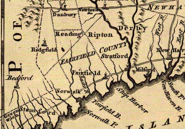
Connecticut
maps from the 1700's all use Reading, Connecticut: 1771,
1795, 1797
as do Revolutionary War references to the encampments in our
town. [During the American Revolution the Generals referred
to it as Camp Reading.] Adding to the confusion-Redding
continued to be known as Reading to some into the 1800's as
this map of Connecticut shows: Connecticut
1824
*The
following is the most entertaining reasoning for all the confusion
I've come across so far, it is taken from the Redding Bicentennial
Official Program, 1967:
"We
personally favor the certainly apocryphal story about the
peddler who traveled between Fairfield and Danbury, selling
his goods and providing news and gossip gratis. Every time
he passed through Redding he asked what they were going to
call the new parish-reed or redd.
One
day, on his way south, he walked into Redding and the first
person he saw was the town crier. "Good morning, Town
Crier," the peddler said. "Have you figured out
how to pronounce your name yet?"
The
crier was in bad humor and replied brusquely, "The official
notice was "read" the day before yesterday, it was
read yesterday, it has been "read" this morning,
and it will be "read" tomorrow." (the word
"read" is being pronounced "red" by the
crier)
The
peddler thanked him and went on his way, spreading the news
throughout the land. It has been pronounced "Red-ding"
and spelled Redding ever since.
The
First Grants of Land in Redding
Below
are "grants of land" in present day Redding. Very
few of the individuals granted land actually settled in Redding.
The majority of these grants were sold to Redding's early
settlers.
"The
first deed or grant of land in the 'oblong'' within my knowledge
(Todd) was given to Mr. Cyprian Nichols in 1687 This grant,
in Secretary Wylly's handwriting, reads as follows: At a General
Court held at Hartford, October 13, 1687.
"This
Court grants Mr. Cyprian Nichols two hundred acres of land
where he can find it, provided he take it up where it may
not prejudice any former grant to any particular person or
plantation; and the surveyors of the next plantation are hereby
appointed to lay out the same he paying for it. "Caleb
Stanley."
Captain
Nichols “took up” his grant in that part of the
“oblong” which is now Lonetown, as is shown by the
following document: March 1, A.D. 1711
"Then
laid out ye Grant of two hundred acres of land granted by
ye General Court to Capt. Cyprian Nichols, Oct. 13, 1687,
as follows, viz., beginning at a great Chestnut tree marked
on ye south and west side, and J. R. (John Read?) set upon
it, standing at ye southend of Woolf Ridge, a little below
Danbury bounds, thence running west one hundred rods to a
Walnut tree marked on two sides, then running south one mile
to a red oak tree marked, then running east one hundred rods
to a black oak tree marked, then running north one mile to
the Chestnut tree first mentioned. An heap of stones lying
at the root of each of ye trees. We say then thus laid out
by us.
Thomas
Hoyt, Daniel Taylor Surveyors of the Town of Danbury.
"Entered in ye public books of Entry's for Surveys of
Land, folio 14, per Hezekiah Wyllys, Secretary. March 21,
1711.”
The
next two grants in this tract of which we have any record
were made, the first, May 7th, 1700, to Mr. Daniel Hilton,
and the second October 10th, 1706, to Mr.Richard Hubbell.
They were laid out nearly at the same time, and side by side,
with the preceding grant, as follows: “March 3rd, A.
D. 1711.
“
Then laid out ye Grant of two hundred acres of land made by
ye General Court to Daniel Hilton, May 7, 1700, and ye Grant
of one hundred acres, granted October 10th, 1706, by ye General
Court to Mr.Richard Hubbell, all in one piece as followeth,
viz., Beginning at a Walnut tree marked, and J. R. (John Read?)
upon it, standing a little way North East from ye Hog Ridge,
between Danbury and Fairfield, thence running two hundred
and eighty rods northerly to a Red Oak tree marked, on ye
Westside of Stadly Ridge, thence running easterly one hundred
and eighty four rods to the Little River at two Elm Staddles
and a Red Oak, marked, thence running Southerly, west of ye
river, and bounded upon it, two hundred and eighty rods to
a bitter Walnut tree, marked, thence running one hundred and
sixty rods westerly to the Walnut tree first mentioned, thus
and then laid out by us.
Thomas Hoyt, Daniel Taylor Surveyors of the Town
of Danbury.
These
grants were purchased, probably before they were laid out,
by Mr. John Read (J.R.), one of the earliest actual settlers
of Redding. Mr. Read was a gentleman of education, and later
became an eminent lawyer in Boston.
"Other"
Grants of Land in Redding
Above
are the pre-settlement grants according to Charles Burr Todd.
There appear to be many more and I've listed what I've found
to-date (March, 2007) below. What is confusing in almost every
case is that the location of the land granted is not cleary
stated by the General Court. For example, they read as follows:
In
Fairfield Probate Records 8:248-249 is an Indian Deed of
Umpawaug to Nathan Gold in December, 1686. This deed is
an "eye crosser" so I'll only list the parts that
make sense in the present day below:
"Be
it known to all men and those present...(the) rightful proprietors
of a tract or parcel of land called Umpawaug lying westward
of Fairfield in ye wilderness have bargained and sold...from
everyone of us (Indians), our heirs, our heirs executors,
adminstrators, assignees and lawful successors for our [mark]
to Nathan Gold of Fairfield in his majesty's Colony of Connecticut...and
to his heirs and lawful successors for ever a certain parcel
of land called Umpawaug as it is now laided out and bounded
out to the Indians via a river and brook and through a pond
running through ye middle of it and also bounded and marked
(unknown word) the line dividing between said purchased land
and other land now pertaining to the indians running through
the middle of said pond. " (They seem to be stating the
boundary line runs through the middle of the pond, Nathan
Gold owning one side, they owning the other)
The
parcel's boundaries explanation contains many references to
"marked trees" which don't help us much in the present
day, however, two key references are "across ye path
that goeth from Poquiag (Danbury) ye English plantation down
to Norwalke (Norwalk)" and "bounded southeast by
with marked trees to Saugatuck River". The path from
Danbury to Norwalk is Umpawaug Rd. in the present day so this
parcel was likely a large rectangular running from Umpawaug
Pond (half-way through it, if I'm correct on the pond they
reference) on Simpaug Trpk. to the Saugatuck River width wise.
The length or north-south boundaries are difficult to make
out, the northern boundary was likely where Umpawaug Rd. meets
Rt. 53. The southern border would be a complete guess seeing
they state it is where a brook enters the Saugatuck River.
It
ends: "we have laided out ye said land to Nathan and
bounded it as above by said brook and river and in ye pond
and we have marked trees as bounds...for the 2 square miles
of land...it is to be noted said Indian proprietors do hereby
reserve the liberty of hunting upon said land for themselves
in witness of all which we said rightful proprietors have
set to our hands and seals this 29th day of December, 1686.
\
Next:
"General
Assembly of this Colony grants Joseph Webb, minister of Fairfield,
200 acres where it may be had without prejudice to any former
grant or the settlement of any plantation."
With
the General Assembly located in Hartford, a statement like
" where it may be had without prejudice to any former
grant or the settlement of any plantation." could mean
anywhere in the State.
One
grant that is clearly in Redding is Captain John Wakeman's
via a grant to his father Samuel Wakeman in May, 1673. Ironically,
it ends up being next to Joseph Webb's land.
"Whereas
the General Assembly of this Colony, holden at Hartford, May
8th, 1673, did give and grant to Mr. Samuel Wakeman of Fairfield,
200 acres of land; and where as upon the request of Captain
John Wakeman of Fairfield, son of the said Samuel Wakeman,
who is now deceased.
Mr.
John Meredith, surveyor of land in the county of Fairfield,
on the 8th day of April, 1709, did survey and lay out the
said 200 acres of land, in one entire piece, adjoining onto
or very near the northern bounds of the said town of Fairfield
(Cross Highway).
Described
as follows: Beginning at a small staddle (Staddle being: a
base or support, especially a platform on which hay or straw
is stacked.) at the southwest corner of Mr. Joseph Webb's
land in the rear line of Fairfield bounds, and thence running
west by south, half south, along said rear line (Fairfield
Bounds), one hundred rods (16.5 ft. is a rod), to a heaps
of stones, thence running north by west, half west, one mile
(with 4 rods more allowed for a highway between this 200 acres
and rear line of Fairfield boundary) thence east by north,
half north, one hundred rods, to the northwest corner of Mr.
Webb's land, and thence south by east, half east, one mile
and 4 rods, along said Mr. Webb's land, onto the said staddle
first mentioned.
As
by the report of the said surveyor, now laid before this Assembly
it doth and may appear:
Wherefore
this Assembly do allow, approve and confirm the said survey
of the said 200 acres of land, and the land therein mentioned
and surveyed, unto the heirs of the said Samuel Wakeman, deceased,
and do order that they shall have liberty to take out a patent
according to law, for the same."
In
the same 1711 General Assembly notes is found the 600 acres
set aside for a Grammar School adjoining/near the northern
bounds of Fairfield's Long Lots:
"Whereas
the General Assembly of this Colony, holden at Hartford, May
9th, 1672, did give and grant unto the town of Fairfield,
in the county of Fairfield, 600 acres of land, for the maintenance
and support of a grammer school to be kept there; and whereas
at the request of the selectmen of the said town of Fairfield,
Mr. John Meredith, surveyor of land in the county of Fairfield,
on the 8th day of April, 1709, did survey and lay out the
said 600 acres of land, adjoining onto, or near to the northern
bounds of said town of Fairfield. Described as follows:
Beginning
at a certain Chestnut tree, near the road to Danbury (Black
Rock Turnpike), and thence running 352 rods along the rear
line of the said Fairfield bounds to a Great Red Oak tree,
(which is the southeast corner of Mr. Joseph Webb's land)
and thence north by west, half west, one mile (with 4 rods
more allowed for a highway, between this said 600 acres, and
the said rear line of the Fairfield bounds) and thence east
by north, half north, or paralell with said rear line, 352
rods, and thence in a straight line to the Chestnut tree first
mentioned, wherein also is included 100 acres formerly laid
out for George Hull, as by the report of the said surveyor,
now laid before this Assembly, it doth and may appear.
Wherefore
this assembly do allow and approve the said survey of the
said 600 acres of land, and do grant and confirm the same,
unto the inhabitants of the said town of Fairfield for ever,
to be improved in the best manner, for the use and behoof
of a grammar school, to be kept in that town, and for no other
use whatsoever; saving the said 100 acres included within
the said survey, unto the said George Hull; and do order that
the said inhabitants of Fairfield shall have the liberty to
take out a patent for the same."
**Note:
Reviews of the Colonial Records and Fairfield Land Records
also show the following Grants [B. Colley 2007]:
- 80 acres to
Richard Osborn in 1671;
- 200 acres to
Thomas Hanford in 1674 (Thomas Hill acquired land
in 1724);
- 200 acres to
Simon Couch date unclear.
- 160 acres to
John Banks date unclear. (Joseph Banks acquired land);
- 200 acres to
Israel Chauncey in 1681;
- 2 Square Mile
Tract (800 acres) in Umpawaug to Nathan Gold in 1686
(appears to have grown to 1,020 acres over time);
- 100 acres to
Jonathan Bell in 1687 (John Edwards and Samuel Couch
acquired 100 acres, plus additional 60 acres in 1712.)
- 200 acres to
Cyprian Nickols in 1687 (Acquired by John Read in
1712);
- 150 acres to
Dr. Isaac Hall in 1697 (this 150 acres in eastern
Redding north of Church Hill Road to Isaac, Jr., Francis
and John Hall via indian deed in 1709);
- 80 acres, by
indian deed to Thomas Morehouse in 1689;
- 200 acres (see
survey above) north of Redding Center on Webb's Ridge to
Joseph Webb in 1699;
- 200 acres to
Daniel Shelton in 1700 (Acquired by John Read in
1710);
- 100 acres to
Richard Hubbel in 1706. (Acquired by John Read in
1711);
- 150 acres to
William Hill in 1709;
- 600 acres (see
survey above) east of Little River to Redding Ridge, for
Fairfield School to Moses Knapp in 1718;
- 200 acres to
Captain John Wakeman in Redding Center 1709.
August
1722 Captain Samuel Couch and Nathan Gold (Gold died in 1723)
of Fairfield purchased the remaining land in the oblong via
auction at Fairfield. Later Thomas Nash enters the picture
as a land owner, purchasing some of the acreage from Couch.
*The
approximate total acreage in the "oblong" is 7,600,
if the totals listed above are added up they equal 3,950 acres.
View
a Map of the "oblong", this map give you a rough
idea of the size and boundaries.
The
General Court of 1712 had ordered that all the lands lying
in the "oblong/peculiar" a.k.a "vacant lands"
between Danbury and Fairfield, not taken up by actual settlers,
should be sold in Fairfield at public venue via the "motion/petition
of the settlers of Danbury" noted in the Colonial Records,
May of 1712. This land, however, was not sold until the August
of 1722, when it was bid off by Captain Couch for himself
and Nathan Gold, Esq. (deputy Governor of Connecticut). No
notice of the venue was given to the settlers at Redding,
and when news of the sale reached them they became very much
excited and indignant. Mr. Read at once drew up a protest/petition,
which was signed by all farmers/settlers of said "oblong"
and was presented to the next General Court at New Haven (1723).
It is noteworthy that the Quaker system of dates was used.
General
Assembly Records May, 1725:
"Upon
the petition of Capt. Samuel Couch of Fairfield, showing to
this Assembly that the honorable Nathan Gold and Major Peter
Burr, Esqs, who were empowered by acts of this Assembly in
May 8th, 1712, to sell all the country land between Fairfield
and Danbury, and said gentlemen some years past did sell part
of said land, and on August 22nd, 1723, sold the remainder
of said land to said Couch; Assembly grants to the petitioner
the land...on the condition that the money he bid for the
same be immediately paid into the Colony Treasury, and that
suffiecient highways in every part thereof public and private
uses, as there shall be occation from time to time to be laid
out by the county surveyour...; and saving always to the Indian,
Chicken, what he in his deed to the petitioner hath reserved
and saved to himself and his heirs."
200
acres secured by Thomas Hill in Saugatuck River area (Diamond
Hill area) one mile long by 1/2
mile
wide in 1723. (Later sold to Meeker Family). Not known if
this transaction occurred before or after "vacant lands
auction" mentioned above.
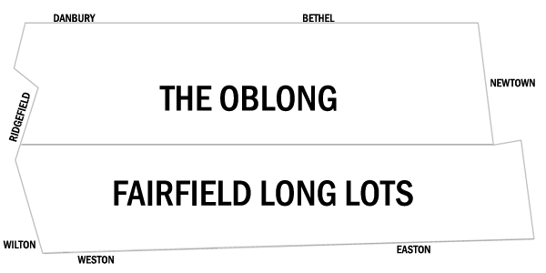
The
Acquisition of land ABOVE the Fairfield Long Lots by Actual
Settlers
The
history of the early settlement of Redding differs from that
of the neighboring towns. A new settlement was generally formed
by a company of men, who purchased of the Indians a tract
of land in the wilderness, had it secured to them by a charter
from the General Assembly, and also surveyed and regularly
laid out, and then removed to it with their wives and families.
Danbury,
Newtown and Ridgefield were settled in this manner; but Redding
at the time of its first settlement was not a part of any
town--a fact which makes it much more difficult to collect
the fragments of its early history and to accurately define
its original metes and bounds.
At the
time of initial settlement, between
the Fairfield long lot's northern boundary (Cross Highway)
and Danbury (Bethel) was an oblong tract of unoccupied land,
whose bounds where about the same as those that now exist
between Redding, Ridgefield, Bethel and Newtown; in the early
records, this tract was called, the "oblong.'' and
the “peculiar"
[To
imagine the northern boundary in the present day: Old Redding
Rd., Diamond Hill Rd., Great Pasture Rd., Cross Highway, and
Church Hill Rd. would be the approximate northern boundary
of the Fairfield long lots. Land north of these roads was
the "country lands between Fairfield and Danbury" or oblong.]
This
area of unoccupied land (or Vacant Land) is where initial
settlers would build their homes and from where settlers would
eventually petition the General Assembly to become a "Parish".
It is not until the settlers of Redding were awarded "Parish
Status" that Fairfield's long lots were added to the
settlement. Land from Cross Highway north to the border of
Danbury and Bethel was not owned by any town prior
to 1729. Colonial Records simply call it the "country lands
between Fairfield and Danbury".
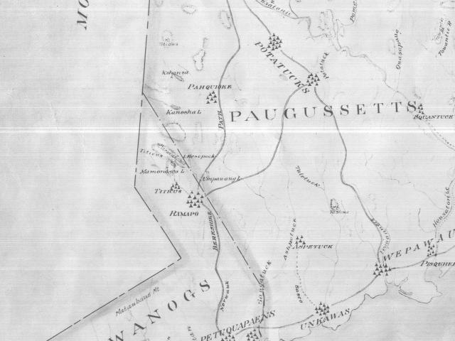
Charles
Burr Todd states that before settlers arrived the unoccupied
lands were: "claimed by a petty tribe of Indians, whose
fortified village was on the high ridge a short distance southwest
of the residence of Mr. John Read (where Lonetown Rd. meets
Putnam Park Rd.). This tribe consisted of disaffected members
of the Potatucks of Newtown and the Paugussetts of Milford,
with a few stragglers from the Mohawks on the west.
[By
"disaffected" I take it that Charles Burr Todd was
saying the "tribe of indians" residing in what we
call the "Lonetown" section of Redding was made
up of Native Americans from multiple tribes displaced from
their homelands by English settlers making their way into
the interior of Connecticut. The "oblong" or vacant
lands between the northern boundary of the Fairfield Long
Lots (Cross Highway) and what is now Bethel was one of the
few available tracts of open space available in the area to
Native Americans at this timeframe. B.Colley2007]
"Their
chief was Chickens Warrups or Sam Mohawk, as he was sometimes
called. Describing "Chickens", President Stiles
says in his "Itinerary" that he was a Mohawk sagamore,
or under-chief, who fled from his tribe and settled at Greenfield
Hill, but having killed an Indian there he was again obliged
to flee, and then settled in Redding. *All the Indian
deeds to the early settlers were given by Chickens, and Naseco,
who seems to have been a sort of sub-chief. The chief, Chickens,
figures quite prominently in the early history of Redding;
he seems to have been a strange mixture of Indian shrewdness,
rascality, and cunning, and was in continual difficulty with
the settlers concerning the deeds which he gave them."
*Not
all deeds were given by Chickens and Naseco. In 1686 an
Indian Deed was given to Nathan Gold for land in Umpawaug
and was signed by Nascro (likely Naseco), Crekonac, Contasonahas,
Mutake (could be Multeg), Wane Sunkeaway, Mamozusacke, Washaganosset,
Aquetake, Iaquoshe. Indian witnesses: Sasco v Joanus, Robin,
Pacomscutt, Misshasouns.
In
1709 an Indian Deed was given to Isaac Hall, Jr., Francis
Hall and John Hall by seven indians: Mohaki, Coocongo, Tom,
Harry, Old Multeg, Siachim, Young Multeg. The deed of 150
acres cost the Hall's 50 shillings, the land was north of
Cross Highway and Church Hill to the Bethel line (Hopewell
Woods/Sunset Hill). There is the possibility, that "Siachim"
was Chickens' attempting to state he was the "Sachem"
of the tribe but technically Chickens is not on this 1709
deed.
[Chickens
is an interesting man, that unfortunately will continue to
baffle me due to a lack of written records by Native Americans.
He appears to have grasped the colonist's methods of obtaining
land in the "interior" meaning he knew they were
exchanging goods and/or money for land away from the coastal
settlements. For example: In 1684, Chickens' name appears
on a deed of Stratford lands, (he was living at Potatuck,
in what became Newtown) and it is possible he was involved
in land transactions in Ridgefield which occurred in 1708-09
(he married a Ramapo). If this is the case, Chickens can be
considered the "Donald Trump" of his people, a real
estate mogul, if you will. If he, in fact, signed a deed in
Stratford/Newtown circa 1684, been involved in land transactions
in Ridgefield circa 1708-09 (made with the Ramapo) and then
moved on to Lonetown in Redding where he collected from John
Read in 1711 and Samuel Couch in 1723, he certainly would/could
be considered quite a Real Estate Investor by modern standards.
This unfortunately is all speculation on my part and there
is a good chance there was more than one Chickens Warrup.]
Fairfield
Long Lots
Long
lots were lands granted to individuals in long, narrow strips
from the coast of Fairfield to approximately Cross Highway
in Redding. The length of these lots was obviously long, the
widths varied from 30.9 feet to 878.6 feet wide depending
on the owner (originally). About 100 Fairfield families owned
Long Lot's. To imagine the northern boundary in the present
day: Old Redding Rd., Diamond Hill Rd., Great Pasture Rd.,
Cross Highway, and Church Hill Rd. would be the approximate
northern boundary of the Fairfield long lots. The reasoning
behind the Long Lots was....each individual received some
hills, some valleys, some rock, some fields. It was a unique
way to give individuals equal qualities of land.
Names
of Oblong Settlers
John
Read settled Redding sometime between 1711 and 1714. He purchased
3 land grants from 3 separate men to make up his original
500 acres in the Lonetown section of Redding. He would later
add 200 more acres.
Moses
Knapp settled Redding sometime between 1709 and 1714. His
settlement is complicated by the methods he obtained his land...via
secret handshake with his cousins. He sold land owned by his
family in Fairfield in 1709, which could indicate he moved
to Redding Ridge shortly afterward. More about his story will
come as information becomes available.
Isaac
Hall, Jr. would settle on Redding Ridge sometime between 1714
and 1720, it appears his brothers: Francis and John Hall remained
in Stratford and sold their portion of the land to Moses Knapp
who was their cousin.
Samuel
Hall is another settler of Redding Ridge prior to 1720. Samuel
is known only via a General Assembly of Connecticut request
in 1720 that orders John Read and "his neighbors"
to submit a "list" to said Assembly via Danbury. Read's neighbors
the Assembly is aware of are: Isaac Hall, Jr., Samuel Hall,
Moses Knapp. Samuel sold land in Stratford/Stratfield on Feb.
22, 1715/6, which could indicate he moved to Redding Ridge
shortly afterward.
Oblong Settlers vs. Long Lot Settlers
What
makes Redding's early settlement different (and down right
confusing) is that it's town boundaries were expanded during
it's attempts to obtain Parish Status. Parish Status meant
the General Assembly of Connecticut recognized the settlement
and the settlers could begin to take steps to become a Town.
Settlers
were petitioning the General Assembly from the Oblong, "Vacant
Land" that wasn't associated with any town. In the 1725
petition for Parish Status, Fairfield Long Lot owners state
to the General Assembly that they "are willing and ready to
give in two miles of our land adjoining the aforesaid Vacant
Land to be within the Parish."
When
Parish Status was finally granted in 1729 Redding became a
recognized settlement of individuals who had made private
purchases of Land Grants in the unclaimed lands above the
long lots AND two miles worth of the northern portion of the
long lots owned by Fairfield residents.
1625 Map
of Indian Trails and Settlements in Southwestern Connecticut.
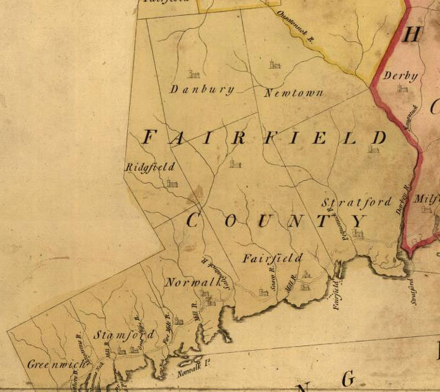
1766 Map
of Southwestern Connecticut, which shows boundary of Fairfield
and Ridgefield matching Sachem boundary in 1625 map of Indian
settlements and trails. At
this time Redding was still a parish in Fairfield's northern
lands.
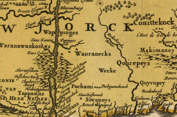
1685 Map
of Indian Settlements in New York & Connecticut.
View
additional Connecticut Map
examples
| |
|
|
| |
The
Barbour Collection of Connecticut Town Vital Records.
Volume 36: Portland (1841-1850), Prospect (1827-1853),
Redding (1767-1852), and Ridgefield (1709-1850)
|
|
Expanded
Information About Redding's Early Settlement
Above
I have provided a summary of Redding's early settlement, below
is further information about the settlement and text from
the multiple petitions for Parish Status, land deeds from
Chicken Warrups, etc..
John
Read and the Anglicans (Episcopalians) of Redding Ridge
John
Read of Fairfield, Connecticut is credited as the first settler
of the lands that would become known as Redding, Connecticut.
Read's settlement coming sometime between 1711 and 1714. Although
20+ years of research by Robert Beecroft is indicating that
Moses Knapp may have settled Redding Ridge just north of Cross
Highway and Church Hill Rd. (256 Black Rock Trpk.) as early
as 1709-10. It's an interesting topic that will be looked
into further I'm sure. There is also the possibility that
Nathan Gold established a farm in the Umpawaug section of
town in the late 1600's. His land deed date is 1686.
Read,
was born in 1679, and educated at Harvard as a Puritan-Congregationalist
minister. He returned to Connecticut with a divinity degree
at the age of 18 and would preach in several different towns
before arriving in Stratford, Connecticut ten years later.
It was in Stratford that Read made two life/career changing
decisions, he *converted to the Anglican (Episcopalian/Church
of England) faith and began studying for the bar.
*Read
resigned as Congregational Minister of the Church on Watchhouse
Hill in Stratford on March 27, 1707 after he was accused of
being an Anglican by his congregation (in private) and a council
of ministers from other parishes in town were gathered to
examined his case. The elders recommended "the people
take all suitable care to purge and vindicate Mr. Read from
scurrilous and abusive reflections." (It does not appear
Read pursued "Holy Orders" to become an Anglican
minister.)
Read
apparently vindicated himself, passed the bar, and quickly
made his mark as a lawyer. He was appointed as an attorney
in 1708, and it appears he gained an interest in large parcels
of land soon after. Read, had several land transactions (Newtown
and New Milford) under his belt by the time his focus turned
to vacant land above the long lots of Fairfield. He made three
separate purchases from three separate men in 1711 to secure
a Colonial Grant for 500 acres of land in Redding's oblong.
A year later he became the Queens Attorney for the Colony
of Connecticut. And in 1714 obtained a native American Indian
deed to finalize the purchase of the 500 acres of northern
Fairfield land he and his family would settle.
*Read
acquired an additional 200 acres from Nathan Gold and Peter
Burr according to Colonial Records of 1729.
Following
Read's settlement in Redding (above the long lots of Fairfield,
Connecticut), other Anglican members from surrounding towns
soon made their way to Redding. Most of these early Anglicans
chose to reside on what is now Redding Ridge, they called
it Chestnut Ridge. Redding Ridge was desirable to these early
settlers because it ran along a path stretching from Danbury
to Fairfield. Roadways were of obvious importance to settlers
and Redding at this time had been surveyed but was not yet
furnished with roads that allowed for east-west travel, even
the route running north-south was merely a series of right-of-ways
over rough terrain.
Given
the fact that John Read was an Anglican sympathizer and the
early settlers (Moses Knapp, Isaac Hall, Samuel Hall, William
Hill, Daniel Crofoot) that followed him were known Anglicans,
it is presumed that they hoped to establish an Anglican
settlement in these vacant lands north of Fairfield's long
lots and south of Danbury's boundary (Bethel). If this was
in fact the case, Redding would not remain solely an Anglican
settlement for long.
Samuel
Couch & Nathan Gold enter the picture (Puritans/Congregationals)
In
August of 1722, two devout Puritans/Congregationalists from
Westport and Fairfield purchased the remaining unclaimed lands
of northern Fairfield (Redding) at an unannounced auction
in the town of Fairfield. This was not a well received transaction
by the Anglicans, as they likely knew Samuel Couch and Nathan
Gold were against the spread of the Church of England in their
county. Read and his settlement petitioned in vain to have
the auction negated, citing the auction "was conducted in
an unseemly and illegal manner" because no notice of the venue
was given to the settlers at Redding. Their request fell on
deaf ears at the General Assembly (Gold was the Deputy Governor
of Connecticut), and settlers with Puritan-Congregational
ideals moved into their "utopia". *to-date no indications
of Anglican vs. Congregationalist arguments have been uncovered
by myself, Brent Colley. Best I can tell, outside of Anglicans
losing their request/petition for an Anglican Minister in
1729, both groups worked and lived peacefully together.
Though
petitions regarding his settlement were unsuccessful, John
Read's prosperity as a lawyer continued, he served as a commissioner
to settle New York and Connecticut's boundary disputes in
1719 and riding that success left Redding in 1722 for Boston,
where he was elected Attorney General of Massachusetts a year
later. His son remained in Redding, taking over his estate
at Lonetown. His son's name was also John Read, which makes
things interesting when time-lining Redding's history, but
it appears John Read Sr. and Jr. worked together petitioning
against the land auction and for Parish status in 1723.
Oblong
Settlers Concern Over The Land Auctions in Fairfield
"At
a General Court held at New Haven, 8th, 10th, 1723. "To
the Honor’ble the General Court: " John Read in
behalf of himself and the rest of the farmers or proprietors
of farms between Danbury and Fairfield, humbly sheweth, "
That the Hon'ble Nathan Gold, Esq., late deceased, and Peter
Burr, Esq., as Agents for ye Colony, held a Venue lately at
Fairfield about ye time of ye Superior Courts sitting yr in
August last, and sold to Capt. Samuel Couch, who bid for himself
and for s'd Nathan Gold, Esq., all ye land between Fairfield
and Danbury not before disposed of for the sum of (Exact Sum
Unknown) Yr humble pet'rs conceive the same ought not to be
ratified: because ye same was done so unexpectedly, and without
sufficient notice, none of us most nearly concerned knew any
thing of it: if ye order of ye General Court had been freshly
passed, ye less notice was need full, but lying ten or twelve
years, sufficient notice was not given, and well considered
it can’t be good. The inconveniences are intolerable;
the place is now growing to be a village space. Ye lands purchased
are but ye ------ ------(Original documents were unreadable
here)over and over for farms.
"
The remaining Scraps will be a very lean and scanty allowance
for a common, and (are) absolutely necessary to accommodate
the place with hiways, and some strips left on purpose for
ye use and ye surveying of the farms--Several farms interfere
through mistakes and such interfere must be supplied elsewhere;
now in such circumstances it was never the hard fate of any
poor place to have ye shady Rock at their door, and ye path
out of town or about town sold away from them by ye General
Court. Therefore, humbly praying ye Hon'ble Court to grant
ye same to ye proprietors of farms there in proportion for
a common and hiways, or if the same seem too much, since some
persons have bid a sum for our hiways we pray to buy them
at first hands, and will pay this Hon'ble Court for the same
as much as ye Court shall set upon, and remain your honor's
most obedient servants. "JNO. READ."
When
the matter came before the Court, Mr. Read produced several
witnesses to show that the venue was conducted in an unseemly
and illegal manner; among them Mr. Jonathan Sturges, who deposed
as following: " Some of the Company began to bid for
s'd land, and some of the Company desired that Mr. Stone who
was there present, would pull out his watch and that the time
for bidding should be but ten minutes and the watch was laid
down on the table; for a little time the people bid but slowly;
but when they perceived the ten minutes to be near out, they
began to bid very briskly, and when it come to the last minute
the people bid more quickly, and at the last they bid so quick
after one another that it was hard to distinguish whose bid
it was: at the very minute the tenth minute ended; but I,
standing near the watch, spoke and said, the time is out,
and it's Capt. Couch's bid, but I am certain Thomas Hill bid
twenty shillings more."
Mr.
Read did not succeed in this attempt to have the sale set
aside, and the lands were adjudged to the purchasers. Captain
Couch seems to have disposed of an interest in a part of his
purchase to Thomas Nash, of Fairfield, and in 1712, did order
to received a joint patent-for the same: this patent is: a
curious and valuable document and is given entire:
"
Whereas, the Governor and Company- of the English Colony of
Connecticut. in General Court assembled at Hartford, the 8th
day of May. Anno Domini 1712, did order and enact that all
those lands (lying within the said Colony) between Danbury
on the north, and the towns of Fairfield and Norwalk on the
south, should be sold at Public Venue, and by act did fully
authorize and empower the Hon'ble Nathan Gold and Peter Burr,
Esq., both of the town of Fairfield aforesaid to make sale
and dispose of the s'd same lands accordingly...
and
whereas the s'd Nathan Gold and Peter Burr in pursuance and
by force and virtue of the aforesaid act did by their deed
in writing, executed in due form bearing late this first day
of May, Anno Domini, 1723, for a valuable sum of money paid
by Samuel Couch and Thomas Nash, both of the town afores'd,
Grant, sell and convey unto them the s'd Samuel Couch and
Thomas Nash one hundred acres of s'd land bounded and butted
as follows...
that
is to say, lying within six rods of the north bounds line
of the townships afores'd, and on both sides of the road that
leads from Norwalk to Danbury, and lying the whole length
of the one hundred acres formerly laid out to s'd Thomas Nash
and bounded westerly by the s'd Thomas Nash, and from the
north east corner of s'd Nash, his bound being a black oak
stump that stands on the land, and a small box wood-tree marked
in course, running northerly, sixty-eight degrees, eastwardly
thirty two rods to a white oak staddle...
thence
South forty three degrees and thirty minutes, eastwardly fifty
rods to a rock, and stone oil the same, that stands on the
eastward side of a brook that runs by the southerly end of
Umpawaug Hill, between the s'd brook and Danbury road, and
from s'd Rock to run North sixty eight degrees...
Eastwardly
eighty six rods to a mass of stones, then South twenty-two
degrees, Eastwardly, one hundred and thirteen rods to a white
oak saplings, marked, standing on the aforementioned North
bounds line of Fairfield, then by s'd line one Hundred and
forty rods up to the South East corner of s'd Nash, his one
hundred acres, Danbury road being allowed in above measure
of six rods wide, and the hiway by the Township's line of
six rods wide, and whereas the s'd Samuel Couch, and Thomas
Nash, have humbly desired that they may have a particular
grant of s'd Governor and Company made (by Patent) unto them,
their heirs and assigns for the same land hounded, butted
and described, under the seal of the s'd Colony,
know
ye therefore, that the Governor and Company of the s'd Colony,
in pursuance, and by virtue of the powers granted unto them
by our late Sovereign Lord, King Charles the Second of blessed
memory, in, and by his Majestie's letters patent under the
great seal of England bearing date the three and twentieth
day of April, in the fourteenth year of his s'd Majestie's
Reign, have given and granted, and by these presents, for
them their heirs and successors do give grant, ratify, and
confirm unto them the s'd Samuel Couch and Thomas Nash, their
heirs and assigns forever, all the s'd piece or parcel of
land containing one hundred acres be the same more or less,
butted and bounded as afores'd, and all and singular, the
woods, timber, under woods, lands, waters, brooks, ponds.
Fishing,
fowlings, mines, minerals and precious stones, upon or within
the s'd piece or parcel of land or every or any part thereof.
To have and to hold the as afores'd, and all and singular,
the rights, members, hereditaments and appurtenances of the
same, and the reversion or reversions, remainder or remainders,
profits, privileges whatsoever, of and in the s'd piece or
parcel of land or every or any-part thereof. To have and to
hold the s'd one hundred acres of land hereby granted with
all and singular, its appurtenances unto them the s'd Samuel
Couch and Thomas Nash, their heirs and assigns to and for
their own proper use, benefit, and behoof from the day of
the date hereof, and from time to time, and at all times forever
hereafter, as a good, sure, lawful; absolute, indefeasible
estate of Inheritance in Fee simple, without any condition,
limitation, use, or other thing to alter, change, or make
void the same.
To
be holden of our Sovereign Lord, King George, his heirs and
successors, as of his Majestie's Manor of East Greenwich,
in the county of Kent, in the Kingdom of England, in free
and common soccage and not in cappitee, nor by Knight service;
they yielding and paying therefor to our Sovereign Lord the
King, his heirs and successors forever, only the fifth part
of all the oar of Gold and Silver, which from time to time,
and at all times hereafter shall be gotten, had or otherwise
obtained; in lieu of all rents, services, duties and demands
whatsoever according to charter. In witness whereof, we the
s'd Governor and Company have caused the Seal of the s'd Colony
to be hereunto affixed, the fourteenth day of May, Anno George,
Magna Brittanniae, &c., Annoque Domini, 1723. (May 14,
1723)
G. Saltonstall, Governor "By order of the
Governor, Hezekiah Wyllys, Secretary.”
General
Assembly Records May, 1725:
"Upon
the petition of Capt. Samuel Couch of Fairfield, showing to
this Assembly that the honorable Nathan Gold and Major Peter
Burr, Esqs, who were empowered by acts of this Assembly in
May 8th, 1712, to sell all the country land between Fairfield
and Danbury, and said gentlemen some years past did sell part
of said land, and on August 22nd, 1723, sold the remainder
of said land to said Couch; Assembly grants to the petitioner
the land...on the condition that the money he bid for the
same be immediately paid into the Colony Treasury, and that
suffiecient highways in every part thereof public and private
uses, as there shall be occation from time to time to be laid
out by the county surveyour...; and saving always to the Indian,
Chicken, what he in his deed to the petitioner hath reserved
and saved to himself and his heirs."
Chicken
Warrup Sells Lonetown Land to Couch
Securing
his auction purchases via Indian Deed, Captain Couch purchased,
of the Indians, the tract of land lying in Lonetown contiguous
to the estate of Mr. John Read. The deed was given by Chickens,
and some of its provisions caused considerable trouble to
the colonists in later years. The deed is as follows:
“Know
all men whom it may concern that I Chicken an Indian Saggamore
living between Fairfield, Danbury, Ridgefield and Newtown,
at a place called Lonetown in the county of Fairfield in the
Colony of Connecticut, in New England, for and in consideration
of twelve pounds, six shillings, already paid unto me by Samuel
Couch of Fairfield.
Husbandman,
have given, granted, bargained, sold, confirmed, and firmly
made over unto said Samuel Couch, his heirs and assigns forever,
all the lands (Chickens was under the impression the
sale was for 200-300 acres not all the lands), lying, being
and situate between the aforesaid towns of Danbury, Fairfield,
Newtown, and Ridgefield, except that has been by letters patent
from the Governor and Company of this Colony of Connecticut
made over unto any person or persons or for any particular
or public use.
To
have and to hold unto the said Samuel Couch, and to his heirs
and assigns forever the aforesaid granted and described lands
or unpatented premises, with all the privileges and appurtenances
thereunto belonging, or any manner of way appertaining, affirming
myself to be the true owner, and sole proprietor of said land
and have lust, firm, and only right to dispose of the same.
(According
to C. B. Todd: a few years later Couch sold this land to John
Read)
*Provision
that would be ignored and anger Chickens:
Reserving
in the whole of the same, liberty for myself and my heirs
to hunt, fish, and fowl upon the land and in the waters, and
further reserving for myself, my children, and grand children
and their posterity the use of so much land by my present
dwelling house or wigwam as the General Assembly of the Colony
by themselves or a Committee indifferently appointed shall
judge necessary for my or their personal improvement, that
is to say my children, children’s children and posterity,
furthermore, I the said Chickens do covenant, promise, and
agree, to and with the said Samuel Couch, that I said Chickens,
my heirs, executors and administrators, the said described
lands and bargained premises, unto the said Samuel Couch his
heirs etc. against the claims and demands of all manner of
persons whatever, to warrant and forever by these presents
defend.
In
confirmation of the above premises I the said Chickens set
to my hand and seal this 18th day of February Anno Domini
one thousand seven hundred and twenty four five Annoque Regis,
etc." (Feb. 18, 1724)
CHICKENS, X (His mark) Saggamtore
Sale
Causes Further Concern and Plea to General Court
The
proprietors of Redding could not long rest with the sale that
had placed, in the hands of two men, nearly all the unoccupied
lands lying in the "peculiar," and in 1725 made
a second and, so far as appears, unsuccessful attempt to reverse
the former decision of the Court. Chickens too was angered
to find the deed he signed was for more land than he intended
to sell. This attempt took the shape of a petition, and was
as follows:
"
To the Honorable the General Court to be holden at Hartford
on the Second Thursday of May,1725.
THE
EARNEST PRAYER: Of the inhabitants, and of those that
have farms in a certain tract of land lying between Fairfield
and Danbury, Newtown and Richfield, with whom the Proprietory
of a certain division of Land in Fairfield importunately joins--
"
Whereas the Honorable General Assembly of this Colony hath
in several of their Sessions, been pleased out of their great
goodness & generosity to give unto some of your humble
Petitioners & to others of them to sell certain Parcels
of Land between the aforesaid towns & many of your Petitioners
that they might get a comfortable maintenance & thereby
be better able to serve their country have removed from their
former habitations with great families of Children unto sd
Land where we by ye blessing of God on our Industry have (passed)
through (the) many difficulties that generally attend such
new & Wooden Habitations and have now yet to go through,
which are by us insuperable--but reflecting upon your Honor's
accustomed Goodness, ready protection, and willing encouragement
towards all such that have been under ye like circumstances
as we now are, makes us far from despairing of Living like
rational Creatures and Christians in a very few years, and
under our present Circumstances we have often the neighboring
Ministers preaching ye word of God to us, and when your Honors
shall be pleased to grant this our earnest & necessary
request our number of Inhabitants will immediately be greatly
renewed & we soon able to obtain a Minister & give
him an honorable support-- and
that is to grant the vacant land that lies in slips and pieces
between ye Land already given and sold to your Petitioners
to ye for a perpetual Common for ye good of ye parish:
Otherwise
your poor Petitioners living at a great distance from any
place where the public worship of God is attended, must be
obliged and their posterity after them to be soon as the Hathen
are without the outward and ordinary means of Salvation, the
thought of which makes us now most impostantly address your
Honors with this our request making no doubt but yt ye desire
your honors have and the great care you have always taken
to promote and encourage Religion will also now be moved to
grant your poor Petitioners their request, it being no more
than your Honors have often done even unto every new plantation,
many of which are not nor never will be comparable unto this.
Your
Honors, granting us this our request, and it will be as we
humbly conceive the most profitable way for ye good of this
Colony to dispose of ye land for a perpetual comon, for ye
good of a parish than any other way whatsoever: for a flourishing
and large parish such as we are assured this will make will
soon pay more into ye Public Treasury than the whole of the
land would do if it were now to be sold: and not only so,
but your poor petitioners and their posterity preserved from
Heathenism and Infidelity:
For
if your Honors should not grant the land for a common for
the good of a parish your poor petitioners-the most of us
are at least, must be shut within the compass of our own land
and cant possibly get off unless we trespass, or gain the
shift yt the birds of the air have, neither to market nor
meeting and we and our posterity forever unable to have a
settled Minister and your Honors may easily conceive how greatly
disadvantageous to our Temporal Interest, which is so great
an act of cruelty and hardship that never yet was experienced
from your Honors and your petitioners humbly beg they may
not: but yt they may be sharers with their neighbors in your
Honor's thoughtful care and regard for them-
and
if your Honors in their Prudence and Wisdom shall think it
best to sell the aforesaid land your petitioners humbly beg
that they may have the first offer of it, who are always ready
to give as much as any shall or will let it lye for a perpetual
Common and your humble petitioners beg and most earnestly
desire the land may not be sold from their doors or confirmed
to any yt pretend they have bought it: for whatever pretended
sale there has been made thereof already we humbly conceive
that it was not with the proper Power and Legality that it
ought to be confirmed: and as for its purchase of the Indian
(who both English and Indian acknowledge) has a good Indian
title to it viz.
Chickens,
is by what we can learn by the Indian himself and ye circumstances
of, a slight piece of policy and we fear deceit, ye latter
of which the Indian constantly affirms it to be, for his
design as he saith, and being well acquainted with him, living
many of us near him have a great reason to believe him, was
to sell but a small quantity, about two or three hundred acres,
but in ye deed ye whole of the land is comprehended, which
when the Indian heard of it he was greatly enraged, and your
petitioners humbly beg yt such a sale may not be confirmed,
lest it prove greatly disadvantageous to this Colony and cause
much bloodshed, as instances of ye like nature have in all
probability in our neighboring provinces-
Your
petitioners most earnestly and heartily beg that your Honors
would think on them and grant them their request and your
petitioners as in duty bound shall ever pray-
John
Read, Thomas Williams, Stephen Morehouse, Benjamin Hambleton,
Benjamin Franklin, Moses Knapp, Nathan Lyon, Benajah Hall,
Will'm Hill, Dan'll Crofoot, Ebenezer Hull, Asa Hall, Joseph
Meeker, Dan'l Lyon, Thomas Hill, George Hull.
And
we, ye proprietors of a certain division of land in Fairfield
called ye Longlots most heartily join with your Honor's above
petitioners in their needful request to you, and as we your
humble petitioners being well acquainted with the circumstances
of them-they being our children, friends, neighbors and concerned
greatly for their welfare do earnestly beg that your Honors
would consider how melancholy a thing it is, that these poor
people should live destitute of the means of grace for want
only of your small encouragement which to give them would
not only be most certainly very pleasing to Almighty God but
would likewise enrich this Colony if a large and rich parish
will any ways contribute thereto and as your petitioners land
runs to and adjoyns to ye aforesaid Vacant Land, we for the
good of a Parish, thereby to advantage your above poor petitioners
are willing and very ready to give in two miles of our land
adjoining to the aforesaid Vacant Land to be within the Parish;
and
are assured if your Honors would grant the afores'd Land to
be for a Comon there soon would be a flourishing Parish; and
being so well acquainted with the circumstances of the above
petitioners that we cant but earnestly and pathetically entreat
your Honors to grant their request and
your petitioners as in duty bound shall ever pray:"
Signed:
Moses
Dimon, John Hide, Tho. Hill, Cornelius Hull, Elizabeth Burr,
Jona Sturgis, John Smith, Thad's Burr, Andrew Burr, Samuel
Wakeman, Samuel Squires, Ezekiel Sanford, Robert Turney, Jr.,
Joseph Wilson, John Wheeler, John Sturges, Joseph Wheeler,
Thomas Sanford, John Morehouse, Joseph Rowland, William Hill,
Nathan Gold, John Gold, Robert Silliman, Daniel Morehouse.
About
the 1725 Petition
From
1723 to 1725, settlement in Redding had increased, and settlers
were petitioning the General Court at Hartford in May of 1725
for Parish Status and assistance in providing for a
Common and better means of travel within their settlement,
in addition, to pleading to have the auction sales
negated.
At
this time, Redding was truly divided into two parts: the Anglicans
occupying the lands above the Fairfield Long Lots and Puritan-Congregationalists
occupying the actual Long Lots. While it is difficult to state
with certainty that both groups co-existed in perfect harmony,
there is evidence of cordial behavior on the part of the Congregationalists
in the 1725 petition.
Twenty-five
Long lots owners signed the northern settler's petition after
adding:
"We,
proprietors of a certain Division of Land in Fairfield, ye
Long Lots, most heartily join with your Honor's above petitioners
in their needful request to you and
being well acquainted
with the circumstances of them - they being our Children,
Friends and Neighbors - we are concerned greatly for their
welfare and do earnestly beg that your Honors would consider
for
the good of a Parish
to grant their request."
They
also state that they "are willing and ready to give in two
miles of our land adjoining the aforesaid Vacant Land to be
within the Parish."
While
the General Court did not grant the petitioners all that they
desired, they did re-survey the cross highway at the rear
of the Fairfield Long Lots which allowed for east-to-west
travel and improved the upright highways between the Long
Lots which allowed for better north-to-south travel in and
around Redding and likely increased Redding's population.
Anglicans
& Congregationalists Win Fight for Parish Status Together
Redding
(then spelled Reading) did finally receive Parish status in
1729, by then a slightly larger number of Congregationalists
had settled along side the Anglicans. I say "slightly larger"
because at the very first meeting of the Parish Society of
Redding, Anglicans "Moses Knapp, Nathan Lion (Lyon), and Daniel
Crofoot" objected against the hiring of any other than a minister
of the Church of England. Their objection or "proposal to
hire an Episcopal minister" was over ruled by a vote of the
people. It was voted that a meeting house would built "for
the worship of God in the Presbyterian (Congregational) way."
Indicating Congregational voters out numbered Anglican voters.
While it is difficult to state with certainty that both groups
co-existed in perfect harmony (in this time period), there
is evidence of cordial behavior on the part of the Congregationalists
as they anticipated the completion of their church building:
On
February 23rd, 1731, a statement was issued that read "all
those persons that inhabit or hereafter may inhabit in this
parish, which profess themselves to be of the Church of England,
shall have free liberty to come into this meeting house and
attend the public worship of God according to the articles
of Divines at Saybrook, and established by the laws of this
Government
"
It's
safe to say the Anglicans graciously declined the offer. In
March of 1732, they wrote a letter of their own, not to the
Congregationalists but to the Bishop of London. It began:
"We, the subscribers, members of the Church of England, in
Reading (Redding) and Newtown, within the County of Fairfield
and Colony of Connecticut
" and continued to request the
services of Rev. John Beach in Redding following his return
from England where he was to receive his Holy Orders "
if
the honorable Society shall think proper." The request was
granted and John Beach became their first rector in November
of 1732.
Like
Redding's founder, John Read, the Reverend John Beach was
also a Congregational minister that converted to the Anglican
faith. His decision was made just a year prior to coming to
Redding on the basis that "The Presbyterian and Congregational
discipline was an 'unscriptural method of organizing and governing
congregations
'" in comparison, he felt the Church of England
was 'Apostolic in her ministry and discipline, Orthodox in
her doctrine, and Primitive in her worship.'"
Anything
you can do...I can do better
Thus,
the Congregational/Anglican theme in Redding continued to
develop:
- John Read,
Sr., converts to the Anglican faith, comes to Redding
- Other Anglicans
soon followed
- Congregationalists
purchase lands in Redding
- Other Congregationalists
soon followed
- Redding becomes
a Parish
- By a vote of
the people, Congregational meeting house will be built in
Redding Center
- Congregational
meeting house erected
- Anglicans make
a plea to the Bishop of London for services
- John Beach,
newly converted to the Anglican faith, comes to Redding
- Anglican meeting
house erected on Redding Ridge
The
old adage: "Anything you can do, I can do better" comes to
mind when mapping Redding's history in this fashion. Records
of two companies of militia in Redding- One commanded by members
of the Congregational society at Redding Center, the other
commanded by officers of the Anglican society at Redding Ridge
as early as 1755, raise an eyebrow but in actuality these
militias were formed in response to the French/Indian War
not disagreements between Congregationalists and Anglicans.
There are no indications of heated conflicts between the religious
groups until the Revolutionary period.
Map of
Redding in 1758. At this time it was still a Parish of Fairfield.
Early
Settlers
The
earliest settlers located their houses on the three fertile
ridges that now form the most striking as well as beautiful
features of our landscape. The valleys were avoided, as being
literally in the shadow of death from the miasms (diseases,
insects) which they engendered; the hills, according to the
early writers, were open, dry, and fertile, land, being comparatively
healthful, were in almost all cases selected as sites for
the infant settlements.
At
that day the hills, like the valleys, were covered with continuous
forests of oak, chestnut, hickory, and other native woods,
from which every autumn the Indians removed the underbrush
by burning so that they assumed the appearance of natural
parks: Indian paths wound through the forest, often selected
with so much engineering skill as to be followed later by
the Highways of the settlers. There were "long-drawn
aisles and fretted vaults" in these verdant temples,
nooks of outlook, and open, sunny glades, which were covered
with tufts of long coarse grass; groves of chestnut and hickory
afforded shelter to whole colonies of squirrels--black, Grey,
and red. Other game was abundant. Deer, wild turkeys, water
fowl, quail, partridges, an occasional bear, and, in the autumn,
immense hocks of wild pigeons darkened the air with their
numbers. Panthers were seen rarely; wolves were' abundant,
and the otter and beaver fished and built in the rivers. Both
tradition and the written accounts agree in ascribing to the
rivers an abundance of fish: Little River is especially mentioned
as being the favorite home of the trout, and tradition asserts
that scarcely four generations ago they were so abundant in
that stream that the Indian boys would scoop them up in the
shallows with their hands according to tradition.
John
Read (Lonetown), Isaac Hall, Jr. (Redding Ridge), Samuel Hall
(Redding Ridge), Moses Knapp (Redding Ridge) are the settlers
known prior to 1720.
Between
1720 and 1725 more settlers flocked from Stratford, Fairfield,
Westport and Norwalk; several families moved here from Ridgefield
and Danbury too. It is not, however, until 1723 that we get
any authentic record of the names of the inhabitants or of
their entire number.
Nathan
Picket, Gershom Morehouse, John Hall, Francis Hill, Robert
Chauncey, Wolcott Chauncey, Daniel -(Illegible), William Hill,
Jr., Phillip Judd, Nathan Adams, Stephen Morehouse, Benjamin
Fayerweather, Thomas Bailey, Thomas Williams, Asa Hall, Joshua
Hull, David Crofut, Jno. Read, Isaiah Hull, Moses Knapp, Benjamin
Sturges, Sam’l Hall, John Read, 2d, Burgess Hall, Isaac
Hall.
In
1725 petition we have the names of settlers above the Long
Lots:
John
Read, Thomas Williams, Stephen Morehouse, Benjamin Hambleton,
Benjamin Franklin, Moses Knapp, Nathan Lyon, Benajah Hall,
Will'm Hill, Dan'll Crofoot, Ebenezer Hull, Asa Hall, Joseph
Meeker, Dan'l Lyon, Thomas Hill, George Hull.
And
the long lot owners/settlers:
Moses
Dimon, John Hide, Tho. Hill, Cornelius Hull, Elizabeth Burr,
Jona Sturgis, John Smith, Thad's Burr, Andrew Burr, Samuel
Wakeman, Samuel Squires, Ezekiel Sanford, Robert Turney, Jr.,
Joseph Wilson, John Wheeler, John Sturges, Joseph Wheeler,
Thomas Sanford, John Morehouse, Joseph Rowland, William Hill,
Nathan Gold, John Gold, Robert Silliman, Daniel Morehouse.
The
settlement of Georgetown seems
to have been begun at about the same time as the other portions
of the town. The first settlers in that section seem to have
been Benjamin and Isaac Rumsey, one of whom lived in a house
that stood in the old orchard east of Aaron Osborne's (Meadow
Ridge Hillside), and the other near the site of the present
homestead of Mr. S. M. Main (Across from Brookside Lane).
As early as 1721 Robert Rumsey, of Fairfield, bought of John
Applegate a large tract of land located in what is now the
village of Georgetown. In 1724 he willed this land to his
three sons, Benjamin, Isaac, and Robert. Benjamin and Isaac
were actual settlers on this tract, and the former's estate
was inventoried and distributed in 1744.
As
roads in and around Redding improved more settlers came to
Redding.
Chicken
Warrup and his Native American
Indian counterparts
First
Encounters: ..." It was claimed by a petty tribe
of Indians, whose fortified village was on the high ridge
a short distance southwest of the present residence of Mr.
John Read." This tribe consisted of disaffected members
of the Potatucks of Newtown and the Paugussetts of Milford,
with a few stragglers from the Mohawks on the west. Their
chief was Chickens Warrups or Sam Mohawk, as he was sometimes
called. President Stiles says in his "Itinerary"
that he was a Mohawk sagamore, or under-chief, who fled from
his tribe and settled at Greenfield Hill, but having killed
an Indian there he was again obliged to flee, and then settled
in Redding. All the Indian deeds to the early settlers were
given by Chickens, and Naseco, who seems to have been a sort
of sub-chief. The chief, Chickens, figures quite prominently
in the early history of Redding; he seems to have been a strange
mixture of Indian shrewdness, rascality, and cunning, and
was in continual difficulty with the settlers concerning the
deeds which he gave them.
Exchange
of Wampum Causes Alarm:...In 1720 he was suspected
by the colonists of an attempt to bring the Mohawks and other
western tribes down upon them, as is proved by the following
curious extract from the records of a meeting of the governor
and council held at New Haven, September 15th, 1720.
It
having been represented to this board that an Indian living
near Danbury, called Chickens, has lately received two belts
of wampumpeag from certain remote Indians--as it is said,
to the west of Hudson River with a message expressing their
desire to come and live in this colony, which said messenger
is to be conducted by aforesaid Chickens to the Indians at
Potatuck, and Wiantenuck, and Poquannuck, in order to obtain
their consent for their coming and inhabiting among them;
and that hereupon our frontier towns are under considerable
apprehensions of danger from Indians, fearing that the belts
have been sent on some bad design:
“It
is resolved, That Captain John Sherman, of Woodbury, and Major
John Burr, of Fairfield, taking with them Thomas Minor, of
Woodbury or such other interpreter as they shall judge meet,
do repair immediately to said Indians at Potatuck and Wiantenuck,
and cause the said Chickens, to whom the belts and messengers
were sent, to attend them, and to make the best inquiry they
call into the truth of said story, and what may be the danger
of said message. and as they shall see cause, take proper
order that the said Indian with the belts, and the principal
or chief of the Potatuck and Wiantenuck Indians, attend the
General Court at its next session, to receive such orders
as may be useful to direct them in their behavior in relation
thereunto; and that Major Burr return home by way of Danbury,
that the inhabitants there and in those western parts may
be quieted as to their apprehensions of danger from the Indians;
if upon inquiry they find there is no just ground for them."
Deeds
from Chickens:...Subsequently Captain Couch purchased
of the Indians a tract of land lying in Lonetown, contiguous
to the estate of Mr. John Read, and which a few years later
he sold to that gentleman. The deed was given by Chickens,
and some of its provisions caused considerable trouble to
the colonists in later years. This deed is as follows: “Know
all men whom it may concern that I Chicken an Indian Saggamore
living between Fairfield, Danbury, Ridgefield and Newtown,
at a place called Lonetown in the county of Fairfield in the
Colony of Connecticut, in New England, for and in consideration
of twelve pounds, six shillings, already paid unto me by Samuel
Couch of Fairfield. husbandman, have given, granted, bargained,
sold, confirmed, and firmly made over unto said Samuel Couch,
his heirs and assigns forever, all the lands, lying, being
and situate between the aforesaid towns of Danbury, Fairfield,
Newtown, and Ridgefield, except that has been by letters patent
from the Governor and Company of this Colony of Connecticut
made over unto any person or persons or for any particular
or public use. To have and to hold unto the said Samuel Couch,
and to his heirs and assigns forever the aforesaid granted
and described lands or unpatented premises, with all the privileges
and appurtenances thereunto belonging, or any manner of way
appertaining, affirming myself to be the true owner, and sole
proprietor of said land and have lust, firm, and only right
to dispose of the same. Reserving in the whole of the same,
liberty for myself and my heirs to hunt, fish, and fowl upon
the land and in the waters, and further reserving for myself,
my children, and grand children and their posterity the use
of so much land by my present dwelling house or wigwam as
the General Assembly of the Colony by themselves or a Committee
indifferently appointed shall judge necessary for my or their
personal improvement, that is to say my children, children’s
children and posterity, furthermore, I the said Chickens do
covenant, promise, and agree, to and with the said Samuel
Couch, that I said Chickens, my heirs, executors and administrators,
the said described lands and bargained premises, unto the
said Samuel Couch his heirs etc. against the claims and demands
of all manner of persons whatever, to warrant and forever
by these presents defend. In confirmation of the above premises
I the said Chickens set to my hand and seal this 18th day
of February Anno Domini one thousand seven hundred and twenty
four five (between 1724 & 1725) Annoque Regis, etc."
CHICKENS, X (His mark) Saggamtore
Respect
Settlers had for Chickens:...it ought to be confirmed:
and as for its purchase of the Indian (who both English and
Indian acknowledge) has a good Indian title to it viz. Chickens,
is by what we can learn by the Indian himself and ye circumstances
of, a sligh piece of policy and we fear deceit, ye latter
of which the Indian constantly affirms it to be, for his design
as he saith, and being well acquainted with him, living many
of us near him have a great reason to believe him, was to
sell but a small quantity, about two or three hundred acres,
but in ye deed ye whole of the land is comprehended, which
when the Indian heard of it he was greatly enraged, and your
petitioners humbly beg yt such a sale may not be confirmed,
lest it prove greatly disadvantageous to this Colony and cause
much bloodshed, as instances of ye like nature have in all
probability in our neighboring provinces-
Ongoing
Troubles with Chickens Lead to His Shipment to Scattacook:...The
next Assembly of 1767 passed the long-desired act of incorporation
it will be noticed that nothing is said in the records concerning
the tribe of Indians inhabiting the parish, but from other
sources we learn that quite important changes·had taken place
among them. “Their chief, Chickens, after causing the
settlers no little trouble concerning the deeds which he had
given them, had been induced in 1749 to remove with most of
his tribe to Scattacook in New Milford, and there were now
but a few scattered families remaining in the town.
No
less than three petitions of Chickens, complaining of the
injustice of the settlers, are preserved in the Colonial Records.
The first, presented to the General Court of May, 1738, asked
that in accordance with the provisions of his deed to Samuel
Couch in 1725, the Assembly would appoint a committee to lay
out to him, his children, children's children, and their posterity,
so much land near his wigwam as they should deem necessary
for his and their personal improvement; and the Assembly appointed
such a committee.
No
report of the action of this committee is preserved in the
archives; but ten years later, in 1745, Chickens again petitioned
the Assembly to appoint a committee to view his lands for
the same purpose, and the Assembly appointed such a committee
“to repair to and deed of conveyance, with the savings
and reservations therein contained, to survey and by proper
meets and bounds set out for, and to the use of the memorialist
and his children, such and so much of said lands as they shall
be of opinion-(on hearing all parties or persons therein concerned)
ought to be allowed and set out to said memorialist and his
children.
The
third and last memorial, and is given in full. “The memorial
of Capt. Chicken alias Sam. Mohawk of Reading in Fairfield
County, showing to this Assembly that in his deed formerly
made to Capt. Samuel Couch, late of Fairfield, deceased, of
his land lying between the township of said Fairfield, and
Danbury, Ridgefield, and Newtown, he had reserved to himself
so much of said land as a committee, appointed by this Assembly,
should judge be sufficient for himself, his children and posterity,
for their personal improvement, which said reserve has since
been set out by proper meets and bounds in two pieces, containing
in the whole about one hundred acres as per the surveys thereof
may appear, reference thereunto being had: and showing also
that John Read, Esq. Late of Boston deceased, had surveyed.,
and laid out to him two hundred acres of land by the appointment
of this Assembly, at a place called Scattacook bounded as
in the survey thereof on record: and also showing that the
land aforesaid, laid out to the said John Read. Esq., is much
more convenient and advantageous for him, the said Chickens,
being well situated for fishing and hunting, and that he had
made and executed a deed of exchange of his aforesaid hundred
acres, lying in two pieces as aforesaid in the parish of Reading
to the said John Read, Esq. and his heirs, which said deed
bears date October 11th, A.D. 1748, and in consideration thereof
did receive of the said John Read, Esq. A deed bearing date
the day aforesaid well executed to him the said Chicken and
his heirs by his heirs by his attorney John Read, Esq. of
said Reading, being fully authorized thereunto, of the aforesaid
two hundred acres; praying this Assembly that said deeds,
executed as aforesaid, may be allowed of ratified, and be
admitted as good evidence in the law for conveying and fixing
the title to the several pieces of land aforesaid.” This
petition the Assembly granted, and Chickens and his tribe
soon after removed to the reservation at Scattacook. His grandson,
Tom Warrup, however, remained in Redding, as will be more
fully related.
Chickens
did have a case as this provision was in the deed to Couch.
BColley2005:
"Reserving
in the whole of the same, liberty for myself and my heirs
to hunt, fish, and fowl upon the land and in the waters, and
further reserving for myself, my children, and grand children
and their posterity the use of so much land by my present
dwelling house or wigwam as the General Assembly of the Colony
by themselves or a Committee indifferently appointed shall
judge necessary for my or their personal improvement, that
is to say my children, children’s children and posterity,
furthermore, I the said Chickens do covenant, promise, and
agree, to and with the said Samuel Couch, that I said Chickens,
my heirs, executors and administrators, the said described
lands and bargained premises, unto the said Samuel Couch his
heirs etc. against the claims and demands of all manner of
persons whatever, to warrant and forever by these presents
defend. "
John
Read #2 took back Warrups' Scatacook land when Chickens returned
and died in Redding.
October 1763
Upon the memorial
of John Read of Fairfield, representing to this Assembly that
one Warrups Chickens, an indian at Reading parish within said
Fairfield, was taken sick in the beginning of December 1762,
under distressing circumstances applied himself to said Read
for assistance, doctors, etc...who at the request of said
Warrups procured doctors and supplied him with provisions
until his death, all to the amount of 11 pounds, 11 shilling,
5 d money, the said Warrups leaving no personal estate wherewith
to satisfy said sum etc.., praying that so much of the said
Warrups farm at Scatacock may be sold as is sufficient to
pay sum and the incident charges arising on such sale, as
per memorial on file.
Resolved: That
Ephraim Hubbel, Esq. of New Fairfield have liberty, and liberty
and authority is hereby granted to him, to sell so much of
Warrups farm at Scatacook as shall be sufficient to pay and
answer said sum of 11 pounds, 11 shillings, 5 d and incident
charges arising on such sale, for the use and benefit of said
Read; the same to be paid over to said Read by Hubbel.[So
much for goodwill to fellow man!!]
The
Adventures of Tom Warrup:...Tom Warrup, an Indian,
son of the chief Chickens, whose story is given in the earlier
pages of this work, and one of Putnam's most valued scouts
and messengers. Tom possessed a great deal of individuality,
and impressed himself on a succeeding, generation to the extent
that numberless anecdotes are remembered and told about him
to this day.
Some
of these, illustrating the Indian character, are worthy the
attention of the grave historian. Tom had a weakness for liquor,
which would have caused his expulsion from the camp had it
not been for his services as scout and guide. One day he was
seen deplorably drunk, and the officer of the day in disgust
ordered him to be ridden out of the camp. A stout rail was
brought, Tom was placed astride of it, four men hoisted it
upon their shoulders, and the cavalcade started. On their
way they met General Putnam with his aids, making the rounds
of the camp. "Tom," said the General sternly, "how's
this?Aren't you ashamed to be seen riding out of camp in this
way ?" “Yes," replied Tom, with drunken gravity.
" Tom is ashamed, vera mooch ashamed, to see poor Indian
ride and the Gineral he go afoot."
Tom's
House: Tom had a house on the high ridge back of
Captain Isaac Hamilton's, now owned by William Sherwood. It
was built, it is said, in primitive Indian style, of poles
set firmly in the ground, then bent and fastened together
at the top. This framework was covered with bark, and roofed
with reeds and rushes. Its furniture consisted of framework
bedsteads, with bedding of skins, wooden bowls fashioned from
pepperage knots, huge wooden spoons, baskets made of rushes
or long grass, pails of birch bark, and an iron pot and skillet
begged or borrowed from the settlers. His sister Eunice was
his housekeeper.
Master
of Revels: Except in war he was a worthless, shiftless
fellow, and lived chiefly by begging; hunting and trapping
were his recreations. He would often absent himself from his
hut for weeks at a time, sleeping in barns or in the forest.
A huge overhanging rock about a mile north of Georgetown often
sheltered him on these occasions, and is still known as Warrup's
rock. Tom's neighbor and landlord before the war was Colonel
John Read, son of the early settler of that name. On one occasion
the colonel had a company of gentlemen from Boston to visit
him, and planned a grand hunt in their honor. Tom was always
master of the revels at such times, and piloted the party
on this occasion. In their rambles through the forests they
came to a spring, and beings thirsty one of the party lamented
that they had left their hunting cups behind. Tom at once
slipped off his shoe, and filling it with water offered it
to the guest to drink; whereupon Colonel Read reproved him
sharply for his ill-breeding. Tom drank from the vessel while
the homily was being delivered and then replaced the shoe,
observing with the haughtiness of a king, " Good enough
for Indian, good enough for white man too."
Life
with Zalmon: After the war Captain Zalmon Read and
Tom were near neighbors, and the former had a cornfield in
dangerous proximity to Tom's cabin; he missed the corn and
suspected Tom, and watching, not only discovered him to be
the thief, but also his ingenious plan of procedure. About
midnight the Indian would come, basket in hand, and seated
on the top mil of the fence would thus address the field:
"Lot, can Tom have some corn?” Tom," the lot
would reply, " take all you want ;" whereupon Tom
would fill his basket with ears and march off. The next night,
as the story goes, the Captain armed himself with a grievous
hickory club, and lay in wait behind the fence. Presently
Tom came, repeated his formula, and proceeded to fill his
basket, but when he returned with it to the fence, it was
occupied by the captain, who proceeded to re peat Tom's formula
with a, variation. " Lot, can I beat Tom ?'' " Yes,"
the lot replied," beat him all he deserves;” whereupon
the fun-loving captain fell upon the culprit and gave him
the thorough beating which his roguery deserved.
Rum,
Whiskey or Cider?: One more anecdote of Tom must
suffice. One day he went to a neighbor's house and demanded
whiskey. No, the neighbor was of the opinion that whiskey
was bad for Tom. "Rum, then" "No." “Cider,”
No, cider was bad too; food he might have to keep him from
starving, but no fire-water." Tom ruminated. ."
Well,)' said he at length, " give me toast and cider"-a
favorite dish in those days--and in this way won the desired
stimulant. Some years after, when age was creeping on, Tom
and his sister removed to the Indian reservation at Scattacook,
in Kent, whither his tribe had preceded him, and the time
and manner of his death was unknown to his white brethren
in Redding.
Clues
to How Chickens Obtained Land in Redding
After
1637 English settlement had extended down the coast of Long
Island Sound, taking land from the Paugussett and Peaquanock
at the mouth of the Housatonic and southern lands from the
Siwanogs to the boundary of New York. By 1658 the settlements
at Fairfield and Stratford had taken so much land, the Peaquanock
petitioned the General Court at Hartford to set aside some
land for them alone before the colonists took it all. The
following year Connecticut created Golden Hill in Bridgeport,
the first Indian reservation in the United States.
With
the exception a few Podunk warriors, the Mattabesic took no
part in the general uprising in Massachusetts and
Rhode Island known as the King Philip's War (1675-76). Many
of the southern New England tribes disappeared entirely or
left the region as a result of this conflict. By 1680 there
were only 1,000 Mattabesic left in Connecticut, at least half
of whom were members of the Housatonic tribes (Paugussett,
Peaquanock, Potatuck, and Weantinock). As white encroachment
continued, the General Court in 1680 established two additional
100 acre reservations for the Paugussett: Coram Hill (Shelton)
and Turkey Hill (Orange). In addition to the three small reserves,
several mixed Mattabesic communities, such as the Paugussett
village at Naugatuck and Tunxis settlement at Farmington,
were still managing to maintain themselves on a rapidly shrinking
land base. Only the Weantinock and Potatuck in extreme west
and northwest portion of Connecticut had retained anything
approaching their original territory. However, even these
small holdings quickly slipped away and passed into white
ownership.
During
the next century, almost all of the Mattabesic lands in Connecticut
would either sold or taken over by the state - in many cases
without native knowledge or consent. Even when the transfers
were legal, the circumstances were often questionable since
the native signatures appearing on the deeds show a clear
pattern of increasingly sloppy signatures and the probable
use of alcohol. Located near the English settlements at the
mouth of the Housatonic, the Pequannock and Paugussett were
the first to feel the pressure.
Between
1680 and 1750, a combination of fraud, harassment, and encroachment
forced many of the native families at the Golden Hill reservation
to leave. Some moved north to the native settlement of Lonetown
near Redding. And in 1748 the Peaquanock at Lonetown (Chickens
& Co.) exchanged the last of their lands at Redding for
200 acres bordering Schaghticoke in Kent, CT.
It
is not known how exactly Chicken obtained the land in Redding.
In 1684, Chicken signed a deed of Stratford lands, and it
states he then was living at Potatuck, in what became Newtown.
Chicken was not a signer of a 1686 deed to Nathan Gold in
Umpawaug. Perhaps after his marriage to the daughter of Catoona,
they removed from the Ramapo lands(Ridgefield) to Potatcuck
(Newtown) which was then part of Stratford until settlers
arrived and he sold land to them there before moving on to
Redding. In Redding he joined members of other tribes settling
on land which had been granted to them by the General Court
of the Connecticut Colony, and settled on a ridge known as
"Wolf's Ridge" which can be seen today located to
the left as you make a right hand turn toward Putnam Park
from Lonetown Road.
My
guess as to how he obtained land in Redding was that he simply
settled there after he left what would become Newtown (Potatuck)
and soon became the leader of the group of indians considered
a "tribe" by the Connecticut General Assemby. The
"tribe of indians" residing in the "Lonetown"
section of Redding was likely made up of Native Americans
from multiple tribes displaced from their homelands by English
settlers making their way into the interior of Connecticut.
Seeing the Oblong was not settled until 1709 - 1714 it was
a large area of available land for the Indians to inhabit.
*Chicken
passed away in 1763. Capt Thomas Chicken Warrups, son of old
Chicken passed away at Schagticoke in 1769. Thomas Warrups
#2, (Chicken Warrups grandson) is noted as a scout in the
Revolutionary War but his death and residence at the time
of his death is not known.
*There
is a very good chance that Chicken Warrups of Redding was
a son of the "Chicken" that signed the land deed
in Stratford in 1684.
Chickens
in Scatacook: In 1748 Captain Chickens, alias
Sam Mohawk, exchanged with John Read, Esq., land in Redding
for land in Scattacook. (This is not completely true, Chickens
was no longer welcome in Redding and was forced to move to
the Scatacook Indian Reservation in Kent, CT.) In 1749 he
left Redding and made his residence in Scatacook. The Warrups
family returned from time to time to work for the Read family.
Chickens died and is buried in Redding.
October 1763
Upon the memorial
of John Read of Fairfield, representing to this Assembly
that one Warrups Chickens, an indian at Reading parish within
said Fairfield, was taken sick in the beginning of December
1762, under distressing circumstances applied himself to
said Read for assistance, doctors, etc...who at the request
of said Warrups procured doctors and supplied him with provisions
until his death, all to the amount of 11 pounds, 11 shilling,
5 d money, the said Warrups leaving no personal estate wherewith
to satisfy said sum etc.., praying that so much of the said
Warrups farm at Scatacock may be sold as is sufficient to
pay sum and the incident charges arising on such sale, as
per memorial on file.
Resolved: That
Ephraim Hubbel, Esq. of New Fairfield have liberty, and
liberty and authority is hereby granted to him, to sell
so much of Warrups farm at Scatacook as shall be sufficient
to pay and answer said sum of 11 pounds, 11 shillings, 5
d and incident charges arising on such sale, for the use
and benefit of said Read; the same to be paid over to said
Read by Hubbel.[So much for goodwill to fellow man!!]
"In
1775, the Assembly ordered that the lands of the Scatacooks
should be leased to pay their debts and defray their expenses.
Thomas Warrups, (Chicken Warrups grandson) was allowed to
sell thirty acres of land to pay his debts and provide for
his family. Three years after, another tract of ten acres
was sold, for the purpose of relieving the indigent circumstances
of the Warrups family. The old squaw of Chickens was still
living, but was blind."
"In
1801, the Scatacooks were reduced to thirty-five, who cultivated
only six acres of land, although their territory amounted
to twelve hundred acres, extending from the Housatonic River
to the New York line. At this time Benjamin Chickens, a descendant
of Thomas Chickens #2, was a careful and industrious farmer
at this place."
[I
have seen a note that was found dated in the early 1800's
that requests the town of Redding pay a resident for room
and board for Eunice Warrups. Who she was or how she arrived
back in Redding is unknown. B.Colley 2007]
Around
the turn of the century "one daughter of the Chicken
family was in Scatacook (Kent) and one in New Haven (Maryanne
Cogswell), who has children-Nancy and Milton Cogswell."
Nancy Cogswell Moody was full-blooded Schaghticoke Indian
1850-1934. Wells Offutt is the only living descendent of Chicken
Warrups known as of 2006, Maryanne Cogswell was his great,
great grandmother.
First
Houses
*The
three first houses in the town were built nearly at the same
time. One was in Boston district, where Mr. Noah Lee's house
now stands (across from Lee Lane on Rt. 107), the second in
the centre, on the site of Captain Davis’s present residence
(about where the Heritage house stands), and the third in
Lonetown, built by Mr. John Read, and which occupied the site
of Mr. Aaron Treadwell's present residence (corner of Lonetown
Rd. and Putnam Park Rd.).
[*This
text as with most of the text on this page comes from Charles
Burr Todd. It is likely that John Read's house was one of
the first in Redding, however, Moses Knapp's north of Cross
Highway and Church Hill Rd. is a possibility too. Nathan Gold
in Umpawaug along with many others in the Aspetuck River vicinity
and on Redding Ridge...notably the Crofoot, Hall, Knapp, Lyon,
Morehouse families to name a few, were early families that
may have had homesteads not mentioned by Todd. BColley2006].
The
First Town House
The
first town house was built early in 1798. It stood nearly
in the centre of the common, a few yards west of the present
building.
From
the plan submitted December 27th, 1797, by the building committee,
we learn that it was "36 feet in length, and 30 feet
wide, with 12 foot posts, covered with long cedar shingles,
the sides with pine." There was a chimney in each end,
and fifteen windows with twenty lights in each. Peter Sanford,
Ezekiel Sanford, Samuel Jarvis, Aaron Sanford, Andrew L. Hill,
and Simon Munger were appointed " to receive proposals
and contract for building the aforesaid Town House."
The builder was Daniel Perry.
The
present "old" town house(still standing and used
today) was erected in 1834. At a town meeting held March 3d,
1834, Mr. Thomas B. Fanton made a proposition "that he
would engage to build a new Town House, same dimensions as
the old one, of good materials, covering to be of pine, with
shutters to the windows, outside of the house to be painted,
and the whole inside and out, to be finished in a workman
like manner, to be erected near the old one, on land belonging
to the town, provided the town will give him $400.00, and
the old house," and engaged to save the town form any
expense on account of the materials provided by the committee
to repair the old town house. This proposition was accepted,
and John R. Hill, Gershom Sherwood, and Aaron Burr,2d, were
appointed a committee "to superintend building said House."
There were objections, however, to having the new house built
on the old site, and a meeting held shortly after voted "
to relocate the house in the building owned by Thaddeus M.
Abbott recently occupied for a school house."
Other
parties objected to this plan, and a third meeting was held
before a site satisfactory to all parties could be agreed
on. This meeting voted to locate it "on the Southeast
corner of Thaddeus M. Abbott's homelot, fronting the public
parade on the South, and on the West of Lonetown highway,
provided that nothing in this vote interferes with the contract
made with Thomas B. Fanton for building said house, and that
it be no additional expense to the town." The building
belonging to Mr. Abbott which stood on this site was moved
away, and the present townhouse erected in the summer of 1834.
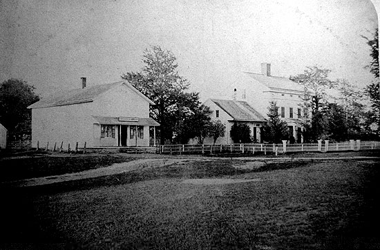
On
the back of this great photo forwarded by Isabella Eredita-Johnson
it reads:
"Thomas B. Fanton home and store Redding, Ct.
House that
William M. Fanton was born in Feb. 12, 1867"
T.B.
Fanton and D.S. Johnson can be found on the
Beers 1867 map where Cross Highway intersects with Sanfordtown
road. Johnson & Nickerson is what the store's sign says.
The store also served as Redding's Post Office for some time.
The first Redding Center post office was said to be located
at the old Town house.
Slavery
Baptist
Church in Georgetown-Blown up:… It was 1838,
the period of the slavery excitement, when abolitionist and
pro-slavery man engaged in almost daily conflict, and men
thought to stifle with shot-gun and bludgeon the first faint
stirrings of the national conscience. A few pithy entries
in the church records thus refer to the affair: " Nov.
26th. Rev. Nathaniel Colver lectured on slavery in our meeting
house-was disturbed by unruly persons. " "27th.
Another lecture on Slavery molested as night before."
" 28th. Meeting house blown up by a mob, but not entirely
destroyed."
This
is all the information the church records, give us on the
subject, but from the files of the Norwalk Gazette for that
year we glean a full account of the affair. This article is
interesting as showings the manner in which even the Whigs
handled the question of slavery at that time. "High-handed
Outrage.-We learn that Judge Lynch has been
exercising his summary proceedings in this vicinity within
the week past. Colver, the abolitionist lecturer, has been
holding forth, as we understand, for a number of evenings,
on the subject of immediate emancipation, in the Baptist church
in Redding, and in the course of his lectures had taken occasion
to exhibit before his audience the practical amalgamationism
of the Vice-President of the United States, the Hon. Richard
M. Johnson. We are informed that he accused this distinguished
personage of making merchandise of the offspring of his own
loins, of selling his own,sons and daughters into slavery.
This so enraged some of his political partisans, that they
determined to abolish the walls which had echoed the nefarious
libel upon ‘Dick, the Tecumseh Killer.' So, after the
lecture was concluded, a keg of gunpowder was deposited under
the church which had been profaned by these abolition orgies-and
about two o'clock on the morning of the 29th ult. the church
was blown ' sky-high,' as John Randolph used to say. It was
a small building of one story, and not worth more than $500.00.
But notwithstanding the provocation, and not withstanding
the comparatively trifling amount of damage occasioned by
this wanton outrage,we most sincerely deprecate: the prevalence
of a spirit which does violence to the dearest rights of every
freeman in the land-the freedom of speech and of opinion.
We are no apologists for the intemperate: and fanatic zeal
of the abolitionists; but we deem it the duty of every press
in the land to cry out against such violations of the Constitution
and laws. And though we would denounce in the severest terms
the exasperating conduct of the abolitionists, we would at
the same time do our utmost to bring the trespassers upon
the rights which the Constitution guarantees to every citizen
and the violators of the public peace, to condign punishment.”
*
*A resident of Georgetown at the time gives the following
additional particulars:
About
two o’clock on the morning following Mr. Colver’s
lecture, the inhabitants of Georgetown were startled by a
tremendous report and rumbling noise, which jarred the houses
and broke the windows in the immediate neighborhood. In the
morning, this unusual disturbance was found to have been caused
by the explosion of a keg of powder which had been placed
directly under the pulpit, a portion of the underpinning of
the church having been removed for that purpose. The pulpit
was demolished, the front of the building displaced several
feet, the windows broken out, and the walls destroyed. This
action of the mob, with the dissensions engendered by it,
proved a sad blow to the church, and from which it never fully
recovered, although it continued in existence for several
years. Elder John H. Waterbury served the church as pastor
for some months in 1839, and was succeeded in 1841 by elder
John Noyes, of North Haven.
Anti-Slavery
Society: One of the earliest antislavery societies
in the State was organized in Georgetown, in December, 1838.
Dr.
Erasmus Hudson and Rev. Nathaniel Colver were appointed by
the Connecticut Antislavery Society agents for the evangelization
of the State, and in October, 1838, entered Fairfield County
in the furtherance of their mission. They lectured at Sherman,
Danbury, Redding, Georgetown, and Norwalk, being driven from
each place in succession by mobs who abused and threatened,
and in some cases stoned them. At Norwalk they were burnt
in effigy, and assailed with brickbats and all manner of missiles.
At Weston they organized the first society in the county.
In
November a call was issued for a convention to be held in
Redding (Georgetown) December 12th, 1838. On the 29th November,
Messrs. Colver and Hudson went to Georgetown to hold meetings.
They met on Monday night in the Baptist Church but the mob
was so violent that the meeting was adjourned until Tuesday
evening. All through Tuesday there was great commotion among
the enemies of the cause, and this culminated in the evening,
when a mob composed of men and boys, some with painted faces
and some wearing masks, surrounded the church, and assailed
it with stones, clubs, and hideous outcries. Being dispersed
by the citizens the band betook itself to quieter forms of
mischief. Dr. Hudson drove to the meeting a beautiful milk-white
horse, and on that night his tail was sheared so closely that
is resembled a corn cob; and other outrages were committed.
At this meeting a society was organized, called the Georgetown
Anti-slavery Society. The constitution of this society bears
date December 4th, 1838; its officers were: President, Eben
Hill; Secretary William Wakeman; Treasurer, John O. St. John.
Proof
of Slave Ownership: From the Couch family biography:
His will dated March 2d, 1712-13, is still in the possession
of Mr. Nash Couch, of Couch’s Hill, who is a lineal descendant.
In this will he gives his “Negro man Jack” and “Negro
maid Jinne” to his wife, in addition to other bequests.
Slaves
and the Church: (This letter is dated at " Reading,
in New England," as all his published reports are, between
1740 and 1760.) "My people are poor, (he continues) and
have but few negro slaves, but all they have, I have, after
instruction, baptized, and some of them are communicants.
From the history of the Christ Church:
There
are about fifty negroes, most of whom after proper instruction
have been baptized there are no heathens or infidels. I commonly
baptize about 100 children in one year, among them some black
children. From the history of the Christ Church, 1769.
Epidemics
in town
Redding
is now much sought after by invalids for its health-giving
properties, but it has been occasionally visited by epidemics
of a fearful character. Small-pox, before Dr. Jenner's discovery
of inoculation, was a fearful scourge, and news of its appearance
in town always excited the wildest apprehension.
The
roads near the infected spot were at once fenced up, and no
one save the physician and nurse was permitted to have any
communication with the stricken family. If the disease became
epidemic, pest-houses were erected in secluded localities
whither the patients were removed. Those dying of this disease
were placed in a rude coffin, and buried at midnight, the
clergyman standing at a safe distance and reading in a loud
voice the service for the dead.
An
epidemic called the " camp distemper" raged in the
town in 1780--the year succeeding the encampment here of Putnam's
division. It seems to have been of the same general character
of the dysentery, but from the fact of its raging more vio-
lently in the neighborhood of the camps was called the camp
distemper. A severer scourge was an epidemic that visited
the town about 1810, and which displayed many of the characteristics
of Asiatic cholera. Strong men were stricken down by it in
a day, and there was scarcely a house where there was not
mourning for the dead.
In
one school district alone, Lonetown, it is said that twenty
died of this disease. The victims of this scourge were interred
in the old cemetery near the Congregational Church. They were
buried hastily, at midnight, and the Rev. Nathaniel Bartlett,
who officiated on the occasion, stood on the ledge a few yards
south of the church, and there read the burial services, in
tones so stentorian, that they were heard by residents on
Umpawaug Hill, fully two miles distant. March 13th, 1797:
“Voted not to admit Small Pox by innoculation; voted
to admit Small Pox by innoculation next fall.”
| |
|
|
| |
The
Barbour Collection of Connecticut Town Vital Records.
Volume 36: Portland (1841-1850), Prospect (1827-1853),
Redding (1767-1852), and Ridgefield (1709-1850)
|
|
Roadways
"The
Roads of Easton and Redding: Their Origins" by Daniel
Cruson
Understanding
the development of towns such as Easton and Redding, as well
as understanding the modern interactions between areas within
these towns and between the towns themselves, can only occur
when the pattern of roads which govern this development and
these interactions is known and understood. In any town, the
road pattern is usually determined as the town is first settled.
This pattern will then be modified as the town grows but through
all of its modifications the basic pattern of roads which
emerges with the first settlers remains. Even today, after
paving, widening and cutting through new roads to give access
to old farm property for subdivisional housing, the basic
patterns established by the crude roadways which were first
cut through the wilderness of northem Fairfield can be seen
by simply glancing a map of Easton and Redding provided one
knows a little of the background of this early road development.
To
understand the basic pattem of roads in the Easton-Redding
area it is first necessary to go back and consider the way
in which the land that would later become these towns was
acquired, divided among Fairfield's proprietor's, and then
settled. The land that became Easton, Weston, and the southern
half of Redding was formally purchased from the local Indians
on January 19,1671 for "36 pounds sterling of cloth valued
at 10 shillings a yard" (i.e. 72 yards of cloth.) Fairfield
had already secured possession of the coastal lands from Black
Rock harbor to the Saugatuck River in what is today Westport,
and extending six miles inland. The Northern Purchase of 1671
, then, gave the town possession of another six miles further
inland so that the town now extended from the coast northwesterly
to an east-west line that coincides with modern Cross Highway
in Redding.
With
a weeks of its purchase, this northem land was divided among
the town's proprietors. This reflected a strong desire on
the part of the town to get all common lands into private
hands quickly and thereby strengthen the town's claims of
ownership over the potential claims of other local Indians
who may have felt entitled to land in this area. In fact,
the Indian John Wampus in 1671 did step forward and try to
claim a substantial parcel of land in Aspetuck. He claimed
this land was his by right of his marriage to the daughter
of Romanock, the chief sachem of the Aspetuck Indians, from
whom she inherited the title of the land at his death ten
years before. After a long and very involved period of legal
maneuvering, the courts awarded the land to the proprietors
to whom it had been distributed for they were in possession
of the land and living on it, whereas Wampus had never actually
taken possession of it.
The
proprietors of Fairfield were those people who were either
the first settlers of the town or descendants of the first
settlers who were entitled to take ownership of a share of
common land as it was divided. A problem accompanied the division
was the land to be equitably divided? This did not mean that
each proprietor was to receive an equal amount of land, for
Proprietors were not equals. Some were far wealthier and,
by the later half of the 17th century owned more land than
others. To these wealthy Proprietors would go the largest
parcels of land. The problem, rather, was to insure that regardless
of its size, no individual would be left with land of poor
quality for farming while another proprietor would end up
with fertile productive land, in addition, the division must
insure against one proprietor receiving land that was tucked
into quality for farming while another proprietor would end
up with fertile productive land. In addition, the division
must insure against one proprietor receiving land that was
tucked into a remote northern region while another received
land that was readily accessible in the southem portion of
the purchase.
The
answer to these distributional problems was the "long
lot". Town officials first began carving up the Northern
Purchase by setting off a strip of land 1/2 mile wide and
which ran across the town from East to West about two miles
above the village of Fairfield. Perpendicular to this Half
Mile Common another strip of land was set off which was one
mile wide and which ran from what is today the green in the
center of Redding, south to the Half Mile Common. This
was appropriately called Mile Common. To either side of the
Mile Common long lots were laid out. These lots were long,
thin stripes of land that ran from the Half Mile Common nine
mile north to the towns northern boundary. They varied in
width from 50 to over 850 feet, the widest lots being given
to the wealthiest and thus more deserving proprietors. Although
their width varied considerably, most of these lots averaged
about 490 acres.
The
long lots were not immediately settled but rather were held
for speculation, either hoping that the land would increase
in value in the future or that it could be given to the proprietor's
sons so that when they came of age they could establish farms
of their own. Land records indicate that these lots were also
frequently sold or traded between proprietors. Regardless,
historians such as Thomas Farnham who have extensively studied
this area, doubt that there was any settlement on these lots
before 1725. This did not mean that the proprietors completely
ignored their holdings to the north, for as soon as land division
is made, concern was expressed over access to the northern
properties and plans for roads were drawn up.
A
year after the 1671 land division a highway was laid out running
East and West of the Half Mile Common. This road assured owners
that they could gain access to the bottom or southern portion
of their long lot. This road survives and is appropriately
called Long Lots Rd. in Westport. Looking at a modern map
of the Westport-Fairfield area, it is easy to see that Long
Lots Rd. forms a straight line east to west, and that Hulls
Farm Rd. and Fairfield Woods Rd. form eastern extensions of
this line. All three of these roads along with several other
shorter ones were at one time connected and formed the northern
boundary between the Half Mile Common and the southern terminus
of the long lots.
Marking
boundaries with roads was a common colonial practice. Modern
Park Ave., which used to be called Division St. or Line Highway,
is the remnant of such a boundary road marking the line between
Stratford and Fairfield after the exact boundary had been
finally worked out in the 1690's. This road was originally
a six rod road meaning that the right of way for the road
was six rods or 99 feet wide (one rod=l6.5 feet). It begins
as it does today in eastern Redding, where modern Stepney
Rd. intersects with it and proceeds south in as straight a
line as topological features will allow, through the campus
of the University of Bridgeport, ending at the monumental
arch which marks the entrance to Seaside Park. One stretch
of the road was probably never completed and that ran from
the intersection with Flat Rock Rd. in Easton south, to a
point just south of the Merit Parkway bridge. This part of
the straight line route is a very narrow part of the Mill
River valley which was formerly known as a wilderness and
scenic area called Nick's Hole. There was a narrow dirt road
that ran up this through this valley and which has become
part of the modern Park Ave., but this road twisted and turned
following the contours of the valley and not running in a
nice straight line as a good boundary road should. (The section
of road between Flat Rock Rd. and the southern end of North
Park Ave. in Easton was destroyed by the Easton Reservoir.)
The
northern boundary of the town of Fairfield was also marked
by a boundary road which is still an important east-west corridor
for Redding. This road consisted of the modern Church Hill
Rd., Cross Highway, Great Pasture Rd., Fox Run Rd., and Seventy
Acres Rd. Looking at a modem map of Redding, it can easily
be seen that these roads form an almost straight line which
bisects the town from east to west. One section of the boundary
road, east of Fox Run Rd. was obliterated when Mark Twain
built his residence, Stormfield, on it and other sections
twist and turn to negotiate the steep hills which characterize
any east west road in this area, but on the whole the route
is straight and direct, making a clear delineation between
the northern long lots and the area to the north which originally
was not claimed by any of the surrounding towns, hence known
as the Peculiar.
Once
the boundary roads were established, thoughts turned to the
need of gaining access to the interior and northern portions
of the long lot themselves. To meet this need the "upright
highways" were laid out starting in 1692. These roads
derived their name from the fact that they ran in an upright
or north-south direction. In fact, they ran slightly to the
northwest or to the 11 o'clock position on an imaginary clock
face so they were also known as "11 o'clock roads."
One stretch of road in Weston is still called by that name.
The upright highways were to run between the long lots giving
owners access to the northern portions of their lots. As a
result it became common to refer to the highways by the name
of the adjacent long lot owner. Modern roads such as Burr
St, Morehouse Highway, and Tumey Rd. are quaint relics of
this practice.
Like
the boundary roads, the upright highways ran in a perfectly
straight line except where geographical features made this
impossible. Sport Hill Rd., for example, runs through Easton
in a straight line except where it deviates to get around
Beacon Hill, where Silverman's orchard has been establish
(just north of the Easton firehouse). The straightness of
these roads derives from the fact that they were laid out
between perfectly straight long lots which in turn were laid
out on paper, regardless of geographical features, before
they were laid out in fact.
Unlike
the boundary roads, few of the upright highways were ever
completely finished. Of the four upright highways that pass
through Easton into southern Redding, only Sport Hill Rd.,
formerly called Jackson's Highway, was substantially completed,
even though it ended, as it still does, at a rock outcropping
on Stepney Rd. about one mile short of the cross highway boundary
road in Redding. As with many of these early roads, rough
terrain north of this point simply made it impractical to
push the highway further. It was far easier to turn to the
west and go up the valley. When geographical obstacles appeared,
our colonial forebearers, like their descendants today, often
took the path of least resistance.
Another
relatively complete upright highway is Morehouse Highway.
Although a bypass has been constructed just where the road
enters Easton, the old road, complete with its hairpin tums
which enabled the traveler to get to the top of the 90 foot
high hill, can still be seen extending north off of Congress
St. across from the Fairfield branch of this road. From the
top of the hill the old upright highway proceeds in the characterisric
straight line fashion, northward across Center Rd., stopping
at Westport Rd. (Rt.#136). At one time the road extended further
crossing Slady's fruit farm . Now this section of road has
been obliterated but it does pick up north of the farm where
it becomes Bibbins Rd.. Bibbins picks up the straight northward
movement to Cedar Hill Rd. At this point the paved road stops
but a remnant of the old road can be seen passing into the
woods north of Cedar Hill, although it appears now as only
two parallel stone walls with clear ground between them. These
walls stop at the base of a rock escarpment and it is doubtful
if the stretch of road which was to be laid out to the immediate
north of this cliff ever was. A more northern section of Morehouse
Highway was laid out in Redding, however. This appears as
Turney Rd. today, and it runs behind Joel Barlow High School.
Up until the beginning of this century the road ran down to
Rock House Rd. in Eastoh. The old route may still be followed
by tracing the parallel line of stone walls as they run south
of the athletic complex. The northern end of Turney Rd. is
its intersection with Meeker Hill Rd., but originally it ran
north to Church Hill Rd., the eastern end of the cross highway
boundary road. A small portion of this northern terminus survives
as Iris Lane.
From
the incomplete nature of Morehouse Highway we have a clue
as to the manner in which these roads were constructed. The
first section of the upright highways to be laid out were
the southernmost which rose perpendicular to the northern
boundary of the Half Mile Common. The lines which determined
the location of these first road sections were establish by
a surveyor in 1692 and it is probable that the first mile
or so of highway was at least cleared of trees and major obstructions.
Because there was no move to settle in the long lots until
the second quarter of the 18th century, however, the highways
were little used after they were first laid out and they quickly
reverted to the wild. Thus we find that the town had to resurvey
the southern limits of the highways in 1707, 1711, and again
in 1714. Only after 1738, when the town again voted "to
clear the highways that run between the long lots", does
mention of surveying and clearing these roads disappears from
town records, implying that there was sufficient travel on
them after this date to keep the roads relatively clear and
the rights of way sharply defined. As Fairfield settled the
interior northern lands, the roads would have been pushed
farther north, until the areas which were last and lightly
settled were reached and geographical obsticals were encountered,
then, as with Morehouse Highway north of Bibbins, there was
little motivation to push the roads further.
At
the same time that the upright highways were being pushed
northward, the sections of these roads that on paper rested
in Redding were begun and pushed southward. Within a year
of purchasing Lonetown Manor in 1714 and thereby beginning
the settlement of Redding, John Read petitioned the town of
Fairfield to survey the back or northern end of the long lots
and with them the northern terminuses of the upright highways.
It is obvious by this request that Read anticipated growth
in the community which he was helping to establish. Only by
determining clearly and definitely the boundaries of the northern
long lots could he expect to induce settlers to either move
north onto their own lots or purchase a section of the northern
long lots from one of the proprietors and build a family farm
on it. In fact, the narrow nature of these lots made it essential
that their boundaries be established before settlement could
occur because a farm could not be established on a strip of
land to 200 feet wide. Thus the northern portion of neighboring
long lots had to be purchased to put together a workable piece
of farm land.
Settlers
also could not be induced to move to the northern long lots
if those lots were inaccessible. Therefore, after the 1714
survey, the northern portion of the upright highways were
laid out and cleared. Thus, even though Morehouse Highway
was never cleared much beyond Bibbins Rd., the northern sections,
Iris Lane and Turney Rd., were.
In
western Redding this process of highway construction can be
seen even more clearly. To the west of Redding center, the
upright highways which passed between the western long lots,
(today Weston) should have continued up to the western extension
of the cross highway boundary road, namely Seventy Acres and
Fox Run Rds. Only two short section of upright highway, however,
appear to have ever been laid out; Dorothy Rd, along with
part of Wayside Lane which are the northern sections of the
upright highway which survives as Bayberry Lane and White
Birch Dr. in Weston, and Goodsell Rd. which was part of the
highway that survives as Old Hide Rd. and North Ave. In western
Redding, then, only the sections of road which were needed
for convenient movement in that area of town, were constructed
and even then they were never run completely north to the
cross highway boundary road.
Another
factor which severly hampered the construction of the western
upright highways was Devil's Den. This piece of land was virtually
useless except for obtaining fire wood and later in the 19th
century, turning it into charcoal. The land is rocky with
little soil and what soil there is tends to be infertile.
Even worse, the terrain in this area is so uneven that even
the pasturing of cattle is dangerous. As a result, Devil's
Den has remained unused, unsable, and open space down to the
present. The terrain not only removed the motovation to push
the highways through this region, but it also made it nearly
impossible. Therefore, the western upright highways were laid
out and cleared through central Weston and there they stop.
Two northern sections of highway are then constructed solely
for local convenience and not to be able to pass back and
forth to Fairfield village as was the original purpose of
these roads.
For
the sake of completeness, the remaining two upright highways
in the eastern long lots should be traced since they are part
of the basic road structure of Easton, as are Sport Hill Rd.
and Morehouse Highway. Just west of Morehouse Highway is Wilson's
Rd. or Highway. Today the road stops at Beers Rd. but originally,
before the Bridgeport Hydraulic Company closed it in 1914,
it continued southerly into and through Fairfield to Fairfield
Woods Rd., the boundary road for the Half Mile Common. In
a northerly direction Wilson's Rd. passes over Westport Rd.
and becomes Old Sow Rd.. it ends where Old Sow Rd intersects
with Center Rd. and it is doubtful that the highway was ever
pushed further north. The terrain north of Center Rd. is extremely
uneven and the road which has become Black Rock Turnpike follows
a much easier course as it goes up the Aspetuck River valley
and over Jump Hill. A road following the same route as modern
Black Rock Turnpike was established very early; probably in
the mid 18th century since many house of that period are found
along its length and because it is mentioned adn mapped by
the British during the Danbury Raid in 1777. With a convenient
road like this passing up to and over Redding Ridge, there
certainlt was no incentive to push Wilson's road further north
nor to construct a northern section of this highway in Redding.
The
last of the upright highways to be considered here is Burr
St. Very little of the original highway is still in existence,
at least in Easton and Redding. The road enters the western
corner of Easton across Division St. and runs a very short
distance before running into Black Rock Turnpike. At one time,
the section of Black Rock Turnpike that runs north to the
intersection with Wesport Rd. was Burr's Upright Highway.
With the flooding of the Hemlock Reservoir, however, Black
Rock Turnpike had to be moved westward where it took over
the identity of Burr's St.. From Westport Rd., the highway
jogged slightly to the west and then passed through one of
the oldest sections of Easton, Gilbertown, to become Norton
Rd.just north of the Gilbertown Cemetary. Norton Rd. today
degenerates into an impassible dirt track north of Freeborn
Rd., but much of its route northward over the top of the ridge
that separates Easton and Weston, can still be substantially
traced on foot. The highway eventually intersected with Den
Rd. (never paved and now effectively closed to public traffic.).
It then proceeded north to become Greenbush and Sanfordtown
Rds. in Redding stopping only at the cross highway boundary
road at the Redding green. The upright highway solved the
problem of north-south travel, but getting east to west was
another matter. The geography of Easton and Redding in characterized
by a series of north-south running ridges. Thus when the north-south
upright highways were being laid out, they extended along
the ridges. This is one reason why they could be so straight.
There were few elevated areas or large geographical obstructions
along these ridges around which the highways would have to
be rerouted. Going east to west, however, necessitated crossing
these ridges and the intervening river valleys therefore causing
the traveler to be almost constantly climbing precipitous
hills or descending into steep sided valleys. Great Hill on
Cross Highway in Redding is a good example. In traveling east
to west on this road, once you have climbed the 150 feet of
hill on modern Church Hill Rd., you pass over a short level
stretch of road around the intersection with Newtown Turnpike.
Then, as the name implies, you descend the 200 feet of Great
Hill to the Little River valley floor only to start up the
other side as soon as you have crossed the river. Similar
climbs and descents are now waiting for you on Great Pasture
Rd. and Diamond Hill before you finally reach the relatively
level area of Seventy Acres Rd.
A
solution to the problem of east-west travel in northern Fairfield
(travel across the long lots)was partially provided by "cross
highways." These highway obviously did nothing to reduce
the elevations over which the traveler had to climb, but they
did provide a cleared right of way which snaked back and forth,
up and down the hill sides. The series of hairpin turns, such
as the one that still survives on Church Hill Rd., served
to reduce the grade up which your horse had to pull your wagon
or up which you yourself had to walk. In the process of course,
the length of the route that you had to travel was somewhat
increased.
In
1734 the town of Fairfield voted to lay out and construct
the cross highways. This probably coincided with the first
movement of settlers onto the long lots. As with most road
building projects on which the colonial towns embarked, the
vote was not acted upon until 12 years later, a time in which
the pace of settlement in the long lots had increased, thus
increasing the pressure on the town to ease the burden of
cross lot travel. The roads were probably not completed until
1758.
Depending
on how they are counted there were six or seven of these cross
highways built in whole or in part. The first and last respectively
were the Long Lots Rd. to Fairfield Woods Rd. boundary road
and the Cross Highway boundary road in Redding. Both of these
were laid out in the 17th century and were not part of the
planned program of cross highways mentioned above. The identity
of the other cross highways constructed after 1746 are obscure.
Old records frequently refer to the same roads using different
highway numbers. Thus the 4th cross highway for one writer
becomes the 5th cross highway for another. By ignoring numbers
and looking for older roads that ran across most of the town,
perpendicular to the upright highways, the major cross highways
for Easton can be at least tentively identified. (Redding
had only the northern boundary road which still retains the
name Cross Highway.)
The
most southerly of the cross highways apparently run just south
of the present Easton border in Fairfield. In terms of todays
roads, this highway consisted of Jefferson and Congress Streets
running all the way from Burr St.. These roads are not a continuous
line today but rather consist of disconnected segments because
of the intervention of the Merritt Parkway, constructed in
the late 1930's. The next or 2nd cross highway was almost
certainly Beers Rd. which, before the Hemlock Reservoir was
created in 1914, began at Burr St. and proceeded east to its
present starting point at Wilson's Rd. (This section included
what is today Division Rd. on the east side of the reservoir.)
The road then proceeded, as Beers does still, to Sport Hill
Rd. on the other side of which it follows the route of modern
Flat Rock Rd. to Park Ave. Almost equally certain is the 3rd
cross highway which appears today as Westport Rd to Center
Rd. Then Center Rd. to Adams Rd. and along Adams Rd. to North
Park Ave.
The
4th and 5th cross highways, however, are much less certain.
We know that for Weston (the westem long lots.) seven cross
highways were planned and were at least partially laid out
(including the cross highway boundary road in Redding). This
would argue strongly that the same number had been planned
for the eastern long lots. Confusing the issue however are
old documents and land records which tend to call Rock House
Rd. Either the 4th or 5th cross highway. The reason for this
inconsistency is not clear. Possibly two cross highways had
been planned above the line of Westport and Center Rds. and
even partially constructed but had not been used, had fallen
into disrepair and thus forgotten. It is quite possible that
the 4th cross highway was in fact Silver Hill Rd. The section
that would have run to the west of Black Rock Turnpike to
Norton Rd. was never completed and the steep hillside of Flirt
Hill over which it would have to pass is probably the reason
why. In addition, it apparently was never completed to the
east of Sport Hill Rd. to Park Ave. This would leave the line
of Valley Rd. to Staples Rd and Sunny Ridge as a probable
uncompleted 5th cross highway. Rock House Rd. which until
recently ran all the way to Black Rock Turnpike and continued
west as the now disused Den Rd., would then be the 6th cross
highway even though it is frequently refered to in contemporary
documents as the 4th cross highway.
The
confusion here is quite probably the result of the pattern
of settlement in infant Easton. When the cross highways were
being laid out between 1746 and 1758, what is now Easton was
just beginning to be settled. As settlers moved into the area,
they tended to concentrate in communities in the west, Gilbertown
(the area around the Bluebird Inn and Easton swimming pool),
and in the east, the Mill River Valley (under the Easton Reservoir).
There was very little settlement in the northem portions of
this area. Therefore, although the location of the 4th and
5th cross highways were determined, there was little need
to construct them since there were so few people in that area
to use the roads. Even if the rights of way had been cleared
of trees and brush, disuse would have quickly allowed them
to revert to forest. The sections that appear to remain were
quite probably in the area of one or two outlying farms whose
owner found segments of these cross highways useful as access
roads to get cattle back and forth to pasture. Farm access
roads frequently became town roads and were paved in the 20th
century.
This
of course leaves the question of why Rock House Rd as the
6th highway was constructed and maintained. The answer to
this lies in Redding. Redding was settled beginning at least
30 years before Easton. Therefore, by the period when the
cross highways were being built, Redding was a thriving community,
having set herself up as an independent parish as early as
1729. Rock House Rd., running just south of the Redding border,
would have been a convenience to those residents living in
the southern part of the town. As a result the road would
have been used and kept open.
A
quick glance at the roads just outlined on a map will show
that, unlike the upright highways, the cross highways were
far from straight. Again the difficulties of travel from east
to west across the town can be invoked as the explanation.
This difficulty is also reflected in the early specifications
for these roads in that they were originally supposed to be
20 rods (330 feet) wide. This extraordinarily wide right of
way could have been seen as necessary to insure sufficient
land to put in the hairpin turns or switchbacks that were
necessary to lessen the grades of these roads up steep hills.
Another
reason for the wide right of way might be to deal partially
with the problem of erosion and mud. When wide roads were
laid out in most early American communities, it was usually
done to ease drainage problems. The center of the right of
way in these roads always consisted of an 18 to 20 foot area
that was bare dirt, kept free from vegetation by heavy traffic.
During the wet season, however, spring rains turned these
dirt tracks into a sea of mud making passage of horses and
riders difficult and of carriages and wagons almost impossible.
At such times it was possible to travel up the sides of the
right of way where there had been little traffic during the
early parts of the year and thus were not stripped of vegetation
which held the soil and maintained relatively firm footing.
Where
roads ran up or down steep grades the mud season posed a special
problem. Water would run down these steep grades and the steeper
the grade, the faster the water flow and the greater the erosion
of the roadbed. In many early hill roads deep gullies were
formed after even a few years of existence. In some remaining
remnants of the early steep roads, which have not been recently
graded or paved, entrenching has lowered the roadbed eight
to ten feet below the old ground surface level. Building hairpin
turns on these roads reduced the grade and consequently the
rate of water run off, but it did not completely stop erosion.
Vegetation along the sides of the right of way would have
further slowed water run off and retarded erosion. Regardless
these measures were only partially successful as existing
relies of these old roads demonstrate. With respect to the
cross highways, the original intentions of the road planners
may have been to deal with these problems by employing the
extraordinarily wide right of way, but expediency, or maybe
it was just the cost of acquiring the extra land, prevailed
and t 2 years after the first proposal, the road width was
reduced to the standard six rods (99 feet).
As
should be apparent from the above discussion, traveling the
colonial and early American road system was not easy, nor
was it fast. In addition to the problems of the mud season,
there were numerous others. Although the right of way of any
of these roads were supposed to be cleared of obstructions,
they rarely were. If a rock was too large to be removed easily
from the traffic path by an ox team, it was left and traffic
was expected to maneuver around it, or, if the rock was low
enough, to go over it endangering wheels and axles. Trees
were cut down but stumps were rarely removed. They were left
to rot and again traffic had to maneuver around them. If the
traffic on any given stretch of road was insufficient to keep
the vegetation down, brush and small trees quickly invaded
the right of way. Farmers living off of these roads were expected
to keep them clear of obstructions, but the town records are
filled with votes to deal with highways that had become impassible
and which need to be maintained.
In
addition to hills that had to be climbed and streams that
had to be forded, swamps also had to be crossed. If the swamp
was small nothing was done and traffic was expected to wade
through it. Occasionally there was an attempt to firm up the
roadbed by pitching rocks into the slime along the right of
way or by setting sections of logs side by side across the
soft areas, but with the weight of passing traffic, the rocks
frequently sank too deep to be useful and logs quickly rotted
and broke through. If the swamp was large, an attempt was
made to build an elevated section or causeway across it by
using rocks and dirt to build up the right of way. This is
in part the origin of the term highway. A relic of this technique
can still be seen in the small segment of old Stepney Rd.(Rt#59)
in Easton which passed immediately to the east of the Baptist
church. The elevated roadway extends for several yards out
into the swamp. It apparently was insufficient and the town
voted to simply go around the edge of the swamp, an alternative
frequently employed by other early American road builders
when faced with a swamp.
Not
only natural factors but humans also impeded movement along
early roadways. Farmers frequently looked upon the roads that
passed through or adjacent to their farms as being extensions
of their lands. Thus the grass growing along the sides and
into the right of way was a resource to be utilized by his
cattle. Negotiating one's way through a herd of grazing cows
is a common annoyance mentioned by early travelers. Farmers
even went so far as to erect gates across the roadway so that
their cattle did not wander too far away. Town meetings down
to the late 19th century were constantly issuing instructions
to their highway surveyor and haywards to remove such obstacles.
Is
it any wonder, with all of these inconveniences, why people
who traveled during these early periods, preferred traveling
by water and if water transportation was not possible, they
preferred to stay home. The state of the roads was one reason
why inland communities tended to be close. To run from Easton
or Redding into Bridgeport or Danbury was not a 20 minute
trip as it is with paved roads and high performance automobiles,
but rather a several hour to half a day expedition, depending
on from where you started. Thus trips to town were infrequent
and done only for pressing business or to pick up such goods
as could not be produced in the community or on the farm.
Needs for social contact and entertainment were satisfied
within the neighborhood and this created a closeness which
has become one of the notable characteristics of colonial
and early American life.
As
imperfect as the roads were and as difficult as travel over
them was, the grid of upright and cross highways was an important
one. At its most basic, this road structure allowed access
to the interior lands that would become Easton and Redding
and thereby encouraged settlement, in the same way that paved
roads and automobiles today have turned these towns into suburbs.
In addition, they allowed movement between neighborhoods within
these areas as well as movement between outlying farms and
the meeting house, general store, and tavern that were so
important to the isolated farmer. In a very real sense they
made these outlying farms possible and road crossings often
determined where whole neighborhoods would develop.
In
a broader sense this early road structure determined the present
pattern of roads in these towns as well as their traffic flows
and patterns of modem residential development. As Easton and
Redding moved into the 20th century, the old upright and cross
highways were the first to become paved and thus they became
the major arteries into and out of town, as well as between
areas within the towns. These early paved roads constitute
the basic road structure of this area. This basic structure
would be modified as old farm access roads became paved to
give access to more remote areas of town. More recently it
would be modified by new subdivision roads which follow a
map line set up to most efficiently develop a parcel of land.
But the basic structure still remains and therefore to understand
the interactions within the towns of Easton and Redding as
well as their development, it is necessary to understand the
patterns and nature of the highways that were first built
in these areas and called upright and cross highway.
"Turnpikes
of Easton and Redding" by Daniel Cruson
As
the 18th century drew to a close, the first stirring of the
Industrial Revolution were being felt both in Europe and the
United States. One of the prerequisites for this industrial
development was a transportation system which provided for
easy and inexpensive movement of raw material to mills and
factories and the movement of finished products out to markets
at home and abroad. In coastal areas, where there was ready
access to water, adequate transportation was much less of
a problem than it was in interior areas like Easton and Redding
where there was neither direct access to the ocean nor any
navigable rivers down which products could be floated by barge
or river boat. The interior, therefore, was forced to rely
on overland transportation and, until the development of railroads
about the middle of the 19th century, this meant reliance
on wagons and the roads over which they had to pass. The state
of the roads in this area, however, was very poor. Overland
transportation even for a single horse and rider, was difficult
and, at times such as the wet spring season, nearly impossible
as dirt roadways dissolved into a sea of mud. This was true
not only in central Fairfield County but in the entire nation
as well.
A
major problem that faced the United States in the 1790's,
then, was how to improve the state of the Nations roads. Road
construction and repair was a very expensive process, and
the federal government had little in the way of money, especially
since direct taxation, such as the Income Tax, would not appear
until the 20th century. In addition there was a strong feeling
among most citizens that the federal Government should stay
out of the road building business. The answer to this dilemma
was to turn the business of road construction and repair over
to private individuals and the most efficient means of doing
this was through incorporation. Thus began an economic period
referred to by historians as the Turnpike Movement.
Individual
states, such as Connecticut, had the right to charter and
thus create corporations. A corporation is a legal entity
which is entitled to sell shares of ownership in itself, called
stocks, in order to raise the money necessary to set itself
up in business. Corporations had occasionally been chartered
for purposes of colonization and various manufacturing processes
in the early colonial period. With the formation of state
governments in the wake of the Revolution, however, the number
of incorporations increased until, by the decade of the 1790's,
this growth became dramatic, especially as corporations were
applied to transportation and the construction, repair, and
improvement of roads and bridges. One type of corporation
that was specifically set up to construct or repair a road
then was the turnpike company.
To
form a turnpike in Connecticut, as in most other states, it
was first necessary for a group of men to draw up a petition
to be submitted to the state legislature asking for the privilege
of incorporation and proposing a route along which the road
would be constructed or, in the case of an already existing
road, improved. Once incorporation was granted, the founders
of the turnpike corporation would meet, elect officers, and
determine how much money was going to be needed to construct
and maintain or improve the roadway. Once this was determined,
the corporation would issue and sell stock. By doing this
the corporation sells small pieces of itself. The money that
is raised by this process is then put toward the acquisition
of land along the proposed route, if a road was not already
in existence, and toward the actual construction or improvement
of the roadbed.
It
is important to remember that the turnpike company was a business
venture and that the purchasers of these early company's stock
expected to receive dividends, a share of the company's profits,
in return for their stock purchase. But where was the money
to come from that would constitute the company's profit? In
the corporation charter, the turnpike company was given the
right to charge a fee or toll to all of those who would be
using the road. The toll rate was carefully controlled by
the state legislature and was to be collected at a tollgate
placed at a convenient location or locations along the length
of the road. The tollgate usually consisted of a small house
in which the toll taker could take refuge in inclement weather,
and a long pole or pike that could be rotated horizontally
on a post to block the road until the toll was paid, and then
rotated out of the way to allow the passage of the toll paid
traffic. It is the turnpikes which gave these roads their
names.
The
tolls which supplied profits and thus dividends, usually made
the formation of turnpike companies a very attractive venture
in areas where there was a substantial volume of traffic passing
in and out of a region. This accounts for the large number
of turnpike companies that were formed in the 1790's and through
the first three decades of the 19th century. By 1800 there
were 219 turnpikes and bridge companies in the U.S. but only
six manufacturing concerns were organized as corporations.
This ratio of manufacturing to transportation corporations
would be reversed by the second quarter of the 19th century
but the figures for the early years of this century clearly
show how profitable and popular the turnpike movement was.
Entrusting road building to private hands rather than to the
government was clearly successful, at least in the early stages
of the Industrial Revolution.
What
was true for the nation, was no less true for the state and
for the towns of Easton and Redding. The basic structure of
roads in these towns had been created by the system of upright
and cross highways constructed in the late 17th and early
18th centuries, but these highways had been laid out first
on paper without regard for the actual patterns of traffic
created by local geography nor the traffic patterns that developed
as the communities grew and prospered. Modifications and improvement
of this basic road structure, then, would be accomplished
by turnpike companies as they perceived the need for new traffic
patterns or improvements to old ones, and acted on these needs
for their own profit.
A
good example of one of these local transportation companies
is the Stratfield and Weston Turnpike Company. [note: Weston
until 1845 included Easton] Chartered as the result of a petition
to the General Assembly in 1797, this company was permitted
to issue stock and with the proceeds from this stock sale
they were to repair and modernize a stretch of road that began
"at the foot of the hill...before the Baptist meeting
house, and extend north in Jackson's Upright Highway so called
until it comes to the Cross Highway about 25 rods [about 400
feet] above the dwelling house of David Silliman" in
Easton. This road today is the section of Sport Hill Road
that runs from the Baptist church, which still stands on the
hill in Stratfield just below Fairfield Woods Road, north
to Rock House Road in Easton. Apparently this stretch of road
was in almost impassible condition and the formation of the
Stratfield and Weston Turnpike Co. was a means whereby the
road could be made fully usable without having those repair
become the concern of the towns involved and without having
to raise taxes to pay for it.
Also
by the provision of their charter, this company was entitled
to set up a toll house and turnpike and to collect tolls according
to a fee schedule that was established by the General Assembly.
The toll house and turnpike were set up at the base of what
is today Sport Hill Road, across from Jefferson Street, where
entrance to the General Electric corporate headquarters driveway
is situated. There it remained for 89 years until the company's
charter was repealed and the road made free in 1886.
The
fees collected at this tollgate were very carefully regulated
since turnpikes were seen as a type of natural monopoly over
which the traveler and resident had no control. For the Stratfield
and Weston Turnpike a fee of 6.2 cents could be collected
for every loaded wagon (half that fee a the wagon was empty),
4 cents for a loaded one horse sleigh, 12.5 cents for a pleasure
carriage of any kind, 4 cents for a man on horseback, and
1 cent for every sheep or pig that was herded through the
tollgate. A penny of course was worth more during this period
than it is today. According to government statistics for consumer
prices at various time in our history, one penny was about
7.5 times more valuable in 1800 than now. Therefore in today's
money every sheep or pig would cost 7.5 cents, every man on
horseback would be charged 30 cents and any pleasure carriage
would have to pay almost a dollar for the privilege of driving
up Sport Hill Road into Easton along a fully modern gravel
road.
Although
these toll rates might seem burdensome, especially for anyone
who used the road regularly to pass back and forth between
Easton and Fairfield or Bridgeport, there were exceptional
circumstances under which the tolls did not have to be paid.
These were also carefully spelled out by the General Assembly.
Exempt were all persons going to or returning from a funeral,
public worship, or a saw or grist mill. In addition, "
all officers or soldiers on days of military exercise on command
who must necessarily pass through...the gate," were exempt,
as were all residents who "live near the place where
the toll gate is erected, whose necessary daily calling requires
their passing the gate.”
The
General Assembly also regulated the way in which revenues
from tolls would be disbursed. As with any business, a portion
of these revenues would be used to cover the cost of repairs
and maintenance of the roadbed and payment of a toll taker.
In a modern corporation, profits, their revenues after all
costs are deducted, are then distributed to the stock holders
as dividends in proportion to the number of shares of stock
owned. The Stratfield and Weston Turnpike Co., however, was
only allowed to distribute an amount of profit to each stockholder
equal to 12% per year of the total amount that the stockholder
had paid for his stock. All money that was left after these
dividend payments had been made were to be used to pay back
the money that the company had collected from its stockholders
as a result of the original stock sales. In this, the money
from stock sales was being treated as a loan rather than a
true investment in the company. Ideally the amount of money
that the stockholder had made available to the corporation,
would be slowly returned to the stockholder until he was entirely
paid back. Then there would no longer be a need to collect
tolls and the road would become free. Since we know that the
Stratfield and Weston Turnpike Co. continued to collect tolls
until 1886 when Fairfield County made all of its turnpikes
free, it is fair to assume that the company never had large
enough revenues to pay back its stockholders, although the
enterprise must have been fairly profitable or it would not
have survived as a corporation for almost 90 years.
Older
than the Stratfield and Weston turnpike Co. by about six months
was the Fairfield, Weston, and Reading Turnpike Co. which
received its charter in May of 1797. This company improved
and maintained a section of road that ran from the home of
Samuel Wakeman Jr. in Easton, across Redding Ridge to the
meeting house in Bethel, which was then part of Danbury. The
Samuel Wakeman house is still in existence and it sits on
route #58, opposite the mouth of Freeborn Road. The turnpike
extended from that point north along route #58 to Sunset Hill
Road. It then went north along Sunset Hill and over Hoyt's
Hill into Bethel as far as the Congregational church. (The
section of modern route #58 which runs from Sunset Hill Road
to Putnam Park, is a new stretch of road that was constructed
around the turn of this century to facilitate access to the
park.)
The
tollgate for this turnpike was located " at the house
of Samuel Thorp," which was apparently located just north
of Jump Hill, on the flat stretch of road which lies just
south of the Redding border. Having their tollgate so far
south on the road posed a revenue problem, however, since
many people were using just the northern sections of this
road and thus not paying tolls for the use of the road. This
problem materialized very early in the company's history,
for in 1798, a little over a year after their formation, they
petitioned the legislature and were granted permission to
establish a tollgate on the northern portion of the road provided
that someone traveling the full length of the road would only
have to pay at one tollgate and not at both. Unfortunately
the location of this upper tollgate was never mentioned in
the legislative records and is therefore unknown. It continued
to function, however, the road was declared free in 1834.
The entire road became free when the company's charter was
repealed in 1838.
Another
turnpike was created in 1832 whose history was to become closely
tied to the Fairfield, Weston, and Redding Co.; The Black
Rock and Weston Turnpike. The company that was chartered to
construct and improve this road was permitted to operate from
Black Rock Harbor northwesterly to a point just north of today's
Westport Road (route #136). The purpose for constructing this
road was obviously to facilitate the movement of farm produce
and other small locally produced goods to the harbor for transshipment
by water to markets in places like New York City and the South.
The road became an even more valuable link to the coast when
it was connected to the Fairfield, Weston,and Redding Turnpike
by a short stretch of road running from Westport Road to Freeborn
Road creating what is still known as Black Rock Turnpike running
from Bethel to Long Island Sound. The road was made entirely
free when the Black Rock and Weston Turnpike Co. was dissolved
in 1851.
Among
the other roads in this area which began as turnpikes are
Newtown Turnpike and Hopewell Woods Road in Redding. These
roads are what remains of the Newtown and Norwalk Turnpike
which was chartered in 1829 to run from the " foot of
Main Street in Newtown, passing near the Episcopal church
in Redding, through the westerly part of Weston, (and) ultimately
to the great bridge in Norwalk at the head of Norwalk Harbor."
Again the motive for building this road was to facilitate
the movement of goods from the interior to the coast. By 1841,
the northern portion of this road running through Redding
and Newtown was made free and tolls were dropped on the rest
of the road by 1851.
The
Fairfield County Turnpike, which ran through both Easton and
Redding, had a relatively short life and ran along a very
confusing route. It was chartered in May of 1834 and its charter
was repealed in 1848 after two changes in location had been
approved in 1836 and 1837. The final route of this turnpike
was supposed to have run from the northern end of the Black
Rock and Weston Turnpike (where routes 58 and 136 intersect
today) across Easton, through eastern Redding to the southwesterly
portion of Newtown, and passing ultimately into Brookfield
ending at "Meeker's Mill." In terms of modern roads,
this turnpike appears to have passed up Westport Road (route#136)
to Staples Road, up Staples to Valley Road, and then followed
Valley Road through Poverty Hollow in Redding and Newtown,
turning down Flat Swamp Road and passing through Dodgingtown.
A
longer lived turnpike, but one with an equally unclear route
was the Weston Turnpike. It was chartered in May of 1828 and
only became a free road when Fairfield County cleared itself
of all turnpikes on March 24, 1886. The route is described
as running "from Philo Lyons to the Black Rock Road in
Fairfield with a branch from Fairfield to the Academy in Weston."
The location of Philo Lyons house is not known precisely but
it probably stood on Morehouse Highway about one mile north
of the junction with Beers Road. From this point on Morehouse
Highway, the turnpike probably ran south to Beers Road, then
west along Beers beyond Wilson Road and under what is now
the Hemlock Reservoir, to end at Black Rock Turnpike. The
section of this turnpike which ran to the west of Wilson Road
was closed and abandoned when the Bridgeport Hydraulic Company
built the reservoir in 1914. The "branch from Fairfield
to the Academy in Weston," was probably Wilson Road from
Beers to Westport Road, to the Staples Academy building which
still exists as part of the parish hall for the Congregational
Church.
A
turnpike about which we have very little information is the
Simpaug Turnpike in northwestern Redding. We do know that
a company was chartered to build this road in 1832. We do
not know when the road was made free but it must have happened
by 1886 when the County abolished its turnpikes. Modern road
names suggest that the turnpike started in the business section
of Bethel and ran southwesterly along what is now route#53
and Side Cut Road to the village of West Redding. From that
point it appears to run along the railroad tracks south and
west to the Topstone area where today it swings out and joins
the Ethan Allen Highway (route #7). It is not known if the
turnpike ever ran beyond its intersection with route#7. It
is also not certain where the name comes from unless it refers
to the Simpaug ponds which lie near its point of origin in
Bethel.
The
road that started as the Branch Turnpike is still an important
east-west corridor through Easton. The company that built
this road was incorporated in May of 1831 and the road itself
extended from Bennett's Bridge across the Housatonic River
(just north of the Rochambeau Bridge which carries route#84
traffic across the same river today.), through south and east
Newtown, Monroe, Easton, and Fairfield, ending in Westport.
Today in Easton this road is Stepney Road (route #59) running
from the village of Upper Stepney to the Easton Rotary (The
four way stop below Union Cemetary and the Baptist Church.)
From the Rotary it becomes Westport Road (route #136) and
runs southwesterly to a point just south of the village of
Westport. This road became free when its charter was repealed
in 1851, 20 years after it had been founded.
One
further turnpike must be considered for the sake of completeness
of this treatment if not for the importance of the road itself;
the Sherman and Redding Turnpike. The company which built
this road was chartered in 1834 and the road ran from the
town of Sherman to either the Newtown and Norwalk Turnpike
in Redding or to the Northfield Turnpike in Weston. According
to Frederick Woods, who wrote the definitive book on the turnpikes
of New England, "it is clear that the plans were carried
out, but it is impossible today to pick out the location."
According to a petition which was filed with the General Assembly
in 1846, the turnpike was "never demanded by public necessity
or convenience and that for six years it had been wholly and
entirely abandoned, and consequently impassible and useless."
From this it would appear that the turnpike had a life span
of less than six years. All that remains of the road today
is a short stretch of road in central Redding which is still
called Sherman Turnpike, running from the Redding Green south
to Newtown Turnpike. Other sections of this turnpike may still
be in existence under other names but since its route north
of the Redding Green is unknown it is impossible to be sure
that any of these other roads lie along the old Sherman Turnpike.
The
Sherman Turnpike was an apparent financial failure which underscores
an important aspect of the entire Turnpike Movement; turnpikes
were a business, supported by private financiers and dedicated
to improving overland transportation without resorting to
federal government control and expenditures nor requiring
tax revenues. As with any businesses, some were failures like
the Sherman Turnpike and others were highly successful such
as the Branch Turnpike which became Westport Road and the
Stratfield and Weston Turnpike which became Sport Hill Road.
The failures had little impact on this area beyond supplying
an occasional place name or reference in an old land deed.
The successes, however, because they served a necessary function
such as getting goods and people from the interior to the
coast, or supplied a public convenience such as getting people
across town easily, survived and became improvements and modifications
of the basic road structure in this area. The Turnpike Movement
was the most important phase in the development of local roads
and transportation between the establishment of the basic
road structure with the upright and cross Highways of the
late 17th century and the concerted push during the early
20th century by the towns themselves to pave all of their
roads. The turnpikes also stand as one of the highest expressions
of the American ideal that the most desirable way to accomplish
something is not through government effort and expenditure
but rather through the exercise of Capitalism and private
enterprise.
| |
|
|
| |
Redding
and Easton
by Daniel Cruson
*Great Photos of Early Redding
|
|
The
Old Turnpike thru Georgetown- by Wilbur F. Thompson. For
many years after the first settlement of our state, the roadways
connecting the towns were very poor. Many were mere "bridle
paths," others were Indian Trails widened into "Cart Paths."
One of these was the Indian Trail leading up from the Sound,
at what is now known as Calf Pasture Beach, through the section
now known as Georgetown, into what is now the city of Danbury.
It was over this trail that the eight families left Norwalk
in 1684, to found the new town of Danbury. And for many years
this trail, widened into a cart path, was the only connecting
link between the two places.
As
the town of Danbury grew, the need of a better means of transportation
became apparent. A survey was made and a new highway was opened
up. From Danbury the turnpike followed South Street to what
is now Reservoir Road, to Long Ridge Road, into West Redding,
up over the Umpawaug Hill, Redding, through what is now Boston
district and Georgetown, and on to Norwalk. The right of way
was six rods wide. It was known as the "great road" from Danbury
to Norwalk.
[On
South Street, Danbury, there is still a mile-stone bearing
the date of 1787, "68 miles to New York, 67 miles to Hartford."]
In
1723 Nathan Gold (Gould) and Peter Burr of the town of Fairfield
sold to Samuel Couch and Thomas Nash, of the same town, one
hundred acres of land in the Parish of Redding, town of Fairfield,
"said land lyeing on both sides of the great road, that leads
from Norwalke to Danbury," showing that the road was in use
at that date.
In
1792 the town of Redding voted to reduce the width of the
Danbury and Norwalk road, in Redding, to four rods.
In
1795 the "Norwalk and Danbury Turnpike Company" was formed.
The company was incorporated for the purpose of "making and
keeping in repair the great road from Danbury to Norwalk -
from Simpaug Brook, Bethel, to Belden's Bridge, Norwalk (now
Wilton) and to erect gates and collect tolls for the maintenance
of the same." Toll gates were erected at intervals along the
road. One was north of where Connery Brother's store once
stood in Georgetown (likely about where Georgetown Auto Body
is located). This was the only road of consequence in the
area and soon became the Post Road.
Proof
of its importance is indicated by the location selected as
Redding's first Post Office. On December 22, 1810, Redding's
first Post Office was established with Billy Comstock as Postmaster,
keeping office in his house which was located at what is today
the corner of Umpawaug and Route 107. Across the street was
a tavern which was also the place where horses were changed
and fresh horses put on. The tavern serviced the stage coaches
as they passed through Redding to meet the Danbury and Norwalk
stage. This location was known as Boston Corners, and for
some time Darling's Corners as well. Later the horses were
changed in Georgetown at Godfrey's store on Old Mill Road.
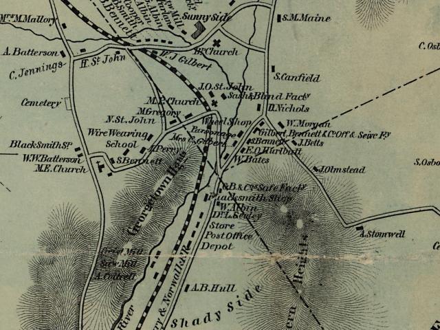
Clark's
Map of 1856 showing Old Mill Road on the right. You'll notice
Old Mill
Road was far more popular than Route 7 (road on the left)
at that time period.
As
the towns grew and the intervening section became thickly
settled, the "Old Turnpike" became a congested thorough-fare.
Historian Wilbur F. Thompson explained that his grandfather,
Aaron Bennett, said "in his boyhood days (1818) there was
an unending procession of great canvas-topped freight wagons,
stage coaches, slow-moving ox carts. Travelers on horseback
and on "Shanks Mares" (pedestrians) passing both ways night
and day." At about this date the Sugar Hollow Turnpike
was opened up. Starting at Belden's Bridge, Norwalk (now Wilton)
on the west side of the Norwalk River, up through Georgetown
and into the Sugar Hollow Valley, along the course of the
river, through the town of Ridgefield, and into the western
side of Danbury. This is now [Route 7] the state road from
Danbury to Norwalk.
The
History of the Norwalk to Danbury Railroad through Georgetown-
by Wilbur F. Thompson. Despite the additional highway
the demand for a better means of transportation began to make
itself felt. In 1825 a survey was made for a canal from Danbury
to tidewater at Westport. From Danbury, through Bethel to
the Saugatuck River in Redding, following the course of the
stream [through Weston] to tidewater. This project was abandoned
when it was found that Danbury was 350 feet above sea level.
In
1835 there were two surveys made for a railroad from Danbury
to Tidewater. One followed the old canal survey to Westport.
The other survey was along the line of the present D. & N.
R. R. It was found that over 8,000 tons of freight was carried
in freight wagons at $5 per ton, and 10,000 passengers were
carried by stage coaches to and from Danbury. The fare was
75 cents from Danbury to Norwalk and 50 cents from sections
in between Danbury and Norwalk. This was the traffic to and
from Danbury in the year 1834.
The
second survey resulted in a proposal for a "horse railway",
a plank roadway or horse path running between the rails. But
nothing was done until 1850, when a contract was awarded to
the Beard, Church & Co. to build and equip a steam railroad.
John Beard was a resident of Danbury.
The
section between what is now Cannondale and Topstone was known
as the Georgetown section. The first work done in this section
was in the deep rock cut known as "Couch's Cut" between Branchville
and Topstone. Cannon & Fields was one of the firms who had
a contract to do the grading on the Georgetown section; Charles
Cannon of Wilton and Frank Fields of Croton Fall, N. Y. Fields
had recently finished a contract on the Harlem R. R. and came
well equipped to do the work.
[Couch's
Cut, was a difficult stretch for the rail workers. There was
quite a bit of rock to get through and dynamite was about
18 yrs. from being invented. Pick axes and black powder were
likely used. Thomas Couch was a partner in the 19th Century
iron foundry at the north corner of Florida Hill Road and
Route 7. Couch's cut comes from his name.]
The
surveyors for the Georgetown section were Aaron B. Whitlock
of Croton Falls, N. Y., and Jebediah I. Wanzer of Pawling,
N. Y. They were assisted by a young man, John W. Bacon, who
later became superinten-dent of the D. & N. R. R. They boarded
with Aaron Bennett, east of Connery's coal yard in Georgetown
(off Old Mill Rd). The boarding house for the men employed
on the section stood north of the Methodist Protestant Church
(later Miller's Hall and now gone).
[If
you were to walk past the dead end on Church Street South,
down the hill and across the railroad tracks you would be
standing in the approximate location of the buildings mentioned
above.]
With
the completion of the Danbury and Nor-walk R.R. in the spring
of 1852, traffic on the old Turnpike grew smaller. The great
freight wagons and stage coaches were soon retired as many
who had traveled on horseback now traveled in railcars.
[The
first train from Norwalk to Danbury went through on March
1, 1852. George Tucker was the engineer and Harvey Smith the
conductor.]
A
one-way trip took 75 minutes using Hinkley Steam Engines named
"The Danbury" and "The Norwalk." Trains would make two round
trips daily for passenger service. The Line did well financially
in the first few years, especially for passenger service.
Almost
immediately after the completion of the RR the Georgetown
Post Off-ice was established on Old Mill Road. The date was
May 11, 1852. The first station agent in Georgetown was Silliman
Godfrey, who was also Postmaster. The next agent was Dr. Lloyd
Seeley, later Burr Bennett, and for many years James Corcoran.
The
station was a two-story building. On the first story was the
Railway Station, Post Office and store kept by Silliman Godfrey.
On the second floor was a large hall used for various purposes.
In 1853 it was the lodge room of Fraternal Division, No. 79,
Sons of Temperance. In the late 1850's it was occupied by
Fanton's shirt factory. In 1862 it was the Armory of Co. E,
23rd Regiment, Connecticut Volunteers, who were mus-tered
into service in the Fall of 1862. Later it was used by the
Gilbert & Bennett Co. for a sieve shop. [The old Railway station
was lost to fire many, many years ago.]

Back
to TOP | Back to Redding
Section | Back to Georgetown
Section
|
|
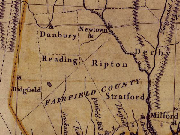
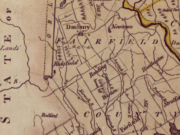
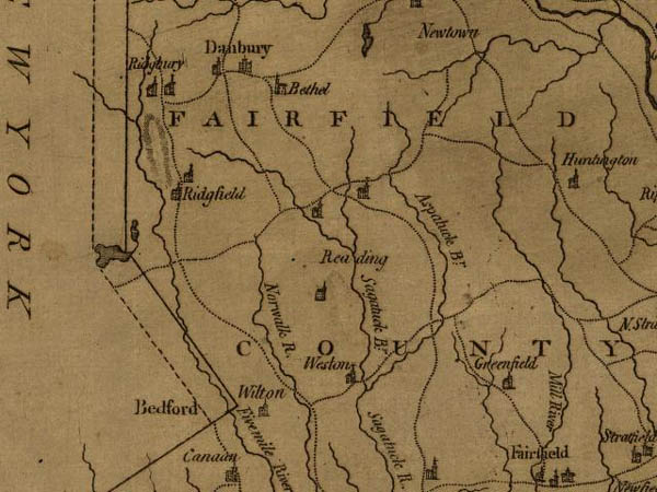