|
Redding's
Scenic Road Ordinance was adopted and became effective in
January 1986, the first in the region. Since that time sixteen
local roads have received Scenic Road designation. These scenic
and rural roads extend for over 18 miles throughout the town
and typify Redding's picturesque charm and character.
In
the words of John Mitchell, author of the 1984 Open Space
Plan, they are:
"pieces of the frame we call our country atmosphere.
We must find a way to preserve them."
If
you would like additional information about the Town's Scenic
Road ordinance please visit: ScenicRoadOrdandWalls.pdf
for the full text of the Scenic Road Ordinance and Stone Wall
Addendum.
Cross
Highway: From Hill Road (Rt. 107) to approximately 700
feet easterly of Newtown Turnpike; Boy's Club property line.
Length in miles of scenic section: 1.9 miles. Date approved:
8 Apr 1997. Scenic Features: Hills and valley, meadows, mature
trees, historic buildings, distant views.
John
Read Road: From Lonetown Road (Rt. 107) to Black Rock
Tpk.(Rt.58). Length in miles of scenic section: 1.08 (entire
road). Date approved: 22 May 1990. Scenic Features: Upland
terrain, meadows, stone walls, woodland, dirt road.
Lee
Lane: From Redding Road (Rt. 107) to end. Length in miles
of scenic section: .32 (entire road). Date approved: 10 May
1988. Scenic Features: Gentle terrain, mature trees, narrow
winding road.
Limekiln
Road: From Redding Road (Rt. 53) to Lonetown Road. Length
in miles of scenic section: 1.7 (entire road). Date approved:
10 May 1988. Scenic
Features: Valley to rugged upland, woodland, distant views,
winding road.
Marchant
Road: From Simpaug Turnpike to Umpawaug Road. Length in
miles of scenic section: 1.8 (entire road). Date approved:
9 Aug 1988. Scenic Features: gentle terrain, meadows, stone
walls, mature trees.
Mark
Twain Lane: From Diamond Hill Road to end. Length in miles
of scenic section: .25 (entire road). Date approved: 22 Oct
1996. Scenic Features: upland slope, stone walls, meadows,
mature trees narrow road.
Old
Hattertown Road: From Poverty Hollow Road to Newtown Town
Line. Length in miles of scenic section: .43 (entire road).
Date approved: 22 Mar 1988. Scenic Features: broad valley,
meadows, woods, winding dirt road
Pine
Tree Road: From Black Rock Turnpike (Rt. 58) to Easton
Town Line. Length in miles of scenic section: .65 (entire
road). Date approved: 8 Aug 1997. Scenic Features: narrow
stream valley, rushing brook, wooded hillsides, narrow road.
Poverty
Hollow Road: From 500 feet south of Stepney Road intersection
to Newtown Town Line. Length in miles of scenic section: 1.94.
Date approved: 12 Sep 1989. Scenic Features: valley terrain,
rushing stream, ponds, waterfalls, meadow forest.
Sherman
Turnpike: From Newtown Turnpike to Sanfordtown Road. Length
in miles of scenic section: 1.0 (entire road). Date approved:
10 May 1988. Scenic Features: valley to hilltop, steep hillsides,
woodland, narrow partly-dirt road.
Side
Cut Road: From Simpaug Turnpike and Long Ridge Road to
Redding Road (Rt. 53). Length in miles of scenic section:
.67 (entire road). Date approved: 13 May 1997. Scenic Features:
broad valley, mature trees, stream.
Station
Road: From Umpawaug Road to Side Cut Road. Length in miles
of scenic section: .44 (entire road). Date approved: 10 Mar
2009. Scenic Features: gentle terrain, stone walls, woodland,
stream, mature trees, narrow.
Topstone
Road: From Chestnut Woods Road to Umpawaug Road. Length
in miles of scenic section: .96. Date approved: 26 Aug 1986.
Scenic Features: rolling terrain, woodland, meadows, mature
trees, dirt road.
Umpawaug
Road: From Redding Road (Rt. 107) to Redding Road (Rt.
53). Length in miles of scenic section: 3.5 (entire road).
Date approved: 22 Jan 2002. Scenic Features: steep hillsides,
hilltop, upland terrain, woodland, winding road.
Wayside
Lane: From Redding Road (Rt. 107) to fork and thence on
both branches to Umpawaug Road. Length in miles of scenic
section: .82 (entire road). Date approved: 10 May 1988. Scenic
Features: ledgy terrain, woodland, stone walls, narrow winding
roads.
Whortleberry
Road: From Gallows Hill Road to Limekiln Road. Length
in miles of scenic section: .80 (entire road). Date approved:
25 Nov 1986. Scenic Features: ledgy upland terrain, woodland,
narrow winding partly-dirt road.
PREPARED
BY THE REDDING PLANNING COMMISSION 2009
A
special thank you to Jerry Sarnelli for forwarding this updated
material!
I
promise to add photos in the near future.
---------------------------------------------
"The
Roads of Easton and Redding: Their Origins" by Daniel
Cruson
Understanding
the development of towns such as Easton and Redding, as well
as understanding the modern interactions between areas within
these towns and between the towns themselves, can only occur
when the pattern of roads which govern this development and
these interactions is known and understood. In any town, the
road pattern is usually determined as the town is first settled.
This pattern will then be modified as the town grows but through
all of its modifications the basic pattern of roads which
emerges with the first settlers remains. Even today, after
paving, widening and cutting through new roads to give access
to old farm property for subdivisional housing, the basic
patterns established by the crude roadways which were first
cut through the wilderness of northem Fairfield can be seen
by simply glancing a map of Easton and Redding provided one
knows a little of the background of this early road development.
To
understand the basic pattem of roads in the Easton-Redding
area it is first necessary to go back and consider the way
in which the land that would later become these towns was
acquired, divided among Fairfield's proprietor's, and then
settled. The land that became Easton, Weston, and the southern
half of Redding was formally purchased from the local Indians
on January 19,1671 for "36 pounds sterling of cloth valued
at 10 shillings a yard" (i.e. 72 yards of cloth.) Fairfield
had already secured possession of the coastal lands from Black
Rock harbor to the Saugatuck River in what is today Westport,
and extending six miles inland. The Northern Purchase of 1671
, then, gave the town possession of another six miles further
inland so that the town now extended from the coast northwesterly
to an east-west line that coincides with modern Cross Highway
in Redding.
With
a weeks of its purchase, this northem land was divided among
the town's proprietors. This reflected a strong desire on
the part of the town to get all common lands into private
hands quickly and thereby strengthen the town's claims of
ownership over the potential claims of other local Indians
who may have felt entitled to land in this area. In fact,
the Indian John Wampus in 1671 did step forward and try to
claim a substantial parcel of land in Aspetuck. He claimed
this land was his by right of his marriage to the daughter
of Romanock, the chief sachem of the Aspetuck Indians, from
whom she inherited the title of the land at his death ten
years before. After a long and very involved period of legal
maneuvering, the courts awarded the land to the proprietors
to whom it had been distributed for they were in possession
of the land and living on it, whereas Wampus had never actually
taken possession of it.
The
proprietors of Fairfield were those people who were either
the first settlers of the town or descendants of the first
settlers who were entitled to take ownership of a share of
common land as it was divided. A problem accompanied the division
was the land to be equitably divided? This did not mean that
each proprietor was to receive an equal amount of land, for
Proprietors were not equals. Some were far wealthier and,
by the later half of the 17th century owned more land than
others. To these wealthy Proprietors would go the largest
parcels of land. The problem, rather, was to insure that regardless
of its size, no individual would be left with land of poor
quality for farming while another proprietor would end up
with fertile productive land, in addition, the division must
insure against one proprietor receiving land that was tucked
into quality for farming while another proprietor would end
up with fertile productive land. In addition, the division
must insure against one proprietor receiving land that was
tucked into a remote northern region while another received
land that was readily accessible in the southem portion of
the purchase.
The
answer to these distributional problems was the "long
lot". Town officials first began carving up the Northern
Purchase by setting off a strip of land 1/2 mile wide and
which ran across the town from East to West about two miles
above the village of Fairfield. Perpendicular to this Half
Mile Common another strip of land was set off which was one
mile wide and which ran from what is today the green in the
center of Redding, south to the Half Mile Common. This
was appropriately called Mile Common. To either side of the
Mile Common long lots were laid out. These lots were long,
thin stripes of land that ran from the Half Mile Common nine
mile north to the towns northern boundary. They varied in
width from 50 to over 850 feet, the widest lots being given
to the wealthiest and thus more deserving proprietors. Although
their width varied considerably, most of these lots averaged
about 490 acres.
The
long lots were not immediately settled but rather were held
for speculation, either hoping that the land would increase
in value in the future or that it could be given to the proprietor's
sons so that when they came of age they could establish farms
of their own. Land records indicate that these lots were also
frequently sold or traded between proprietors. Regardless,
historians such as Thomas Farnham who have extensively studied
this area, doubt that there was any settlement on these lots
before 1725. This did not mean that the proprietors completely
ignored their holdings to the north, for as soon as land division
is made, concern was expressed over access to the northern
properties and plans for roads were drawn up.
A
year after the 1671 land division a highway was laid out running
East and West of the Half Mile Common. This road assured owners
that they could gain access to the bottom or southern portion
of their long lot. This road survives and is appropriately
called Long Lots Rd. in Westport. Looking at a modern map
of the Westport-Fairfield area, it is easy to see that Long
Lots Rd. forms a straight line east to west, and that Hulls
Farm Rd. and Fairfield Woods Rd. form eastern extensions of
this line. All three of these roads along with several other
shorter ones were at one time connected and formed the northern
boundary between the Half Mile Common and the southern terminus
of the long lots.
Marking
boundaries with roads was a common colonial practice. Modern
Park Ave., which used to be called Division St. or Line Highway,
is the remnant of such a boundary road marking the line between
Stratford and Fairfield after the exact boundary had been
finally worked out in the 1690's. This road was originally
a six rod road meaning that the right of way for the road
was six rods or 99 feet wide (one rod=l6.5 feet). It begins
as it does today in eastern Redding, where modern Stepney
Rd. intersects with it and proceeds south in as straight a
line as topological features will allow, through the campus
of the University of Bridgeport, ending at the monumental
arch which marks the entrance to Seaside Park. One stretch
of the road was probably never completed and that ran from
the intersection with Flat Rock Rd. in Easton south, to a
point just south of the Merit Parkway bridge. This part of
the straight line route is a very narrow part of the Mill
River valley which was formerly known as a wilderness and
scenic area called Nick's Hole. There was a narrow dirt road
that ran up this through this valley and which has become
part of the modern Park Ave., but this road twisted and turned
following the contours of the valley and not running in a
nice straight line as a good boundary road should. (The section
of road between Flat Rock Rd. and the southern end of North
Park Ave. in Easton was destroyed by the Easton Reservoir.)
The
northern boundary of the town of Fairfield was also marked
by a boundary road which is still an important east-west corridor
for Redding. This road consisted of the modern Church Hill
Rd., Cross Highway, Great Pasture Rd., Fox Run Rd., and Seventy
Acres Rd. Looking at a modem map of Redding, it can easily
be seen that these roads form an almost straight line which
bisects the town from east to west. One section of the boundary
road, east of Fox Run Rd. was obliterated when Mark Twain
built his residence, Stormfield, on it and other sections
twist and turn to negotiate the steep hills which characterize
any east west road in this area, but on the whole the route
is straight and direct, making a clear delineation between
the northern long lots and the area to the north which originally
was not claimed by any of the surrounding towns, hence known
as the Peculiar.
Once
the boundary roads were established, thoughts turned to the
need of gaining access to the interior and northern portions
of the long lot themselves. To meet this need the "upright
highways" were laid out starting in 1692. These roads
derived their name from the fact that they ran in an upright
or north-south direction. In fact, they ran slightly to the
northwest or to the 11 o'clock position on an imaginary clock
face so they were also known as "11 o'clock roads."
One stretch of road in Weston is still called by that name.
The upright highways were to run between the long lots giving
owners access to the northern portions of their lots. As a
result it became common to refer to the highways by the name
of the adjacent long lot owner. Modern roads such as Burr
St, Morehouse Highway, and Tumey Rd. are quaint relics of
this practice.
Like
the boundary roads, the upright highways ran in a perfectly
straight line except where geographical features made this
impossible. Sport Hill Rd., for example, runs through Easton
in a straight line except where it deviates to get around
Beacon Hill, where Silverman's orchard has been establish
(just north of the Easton firehouse). The straightness of
these roads derives from the fact that they were laid out
between perfectly straight long lots which in turn were laid
out on paper, regardless of geographical features, before
they were laid out in fact.
Unlike
the boundary roads, few of the upright highways were ever
completely finished. Of the four upright highways that pass
through Easton into southern Redding, only Sport Hill Rd.,
formerly called Jackson's Highway, was substantially completed,
even though it ended, as it still does, at a rock outcropping
on Stepney Rd. about one mile short of the cross highway boundary
road in Redding. As with many of these early roads, rough
terrain north of this point simply made it impractical to
push the highway further. It was far easier to turn to the
west and go up the valley. When geographical obstacles appeared,
our colonial forebearers, like their descendants today, often
took the path of least resistance.
Another
relatively complete upright highway is Morehouse Highway.
Although a bypass has been constructed just where the road
enters Easton, the old road, complete with its hairpin tums
which enabled the traveler to get to the top of the 90 foot
high hill, can still be seen extending north off of Congress
St. across from the Fairfield branch of this road. From the
top of the hill the old upright highway proceeds in the characterisric
straight line fashion, northward across Center Rd., stopping
at Westport Rd. (Rt.#136). At one time the road extended further
crossing Slady's fruit farm . Now this section of road has
been obliterated but it does pick up north of the farm where
it becomes Bibbins Rd.. Bibbins picks up the straight northward
movement to Cedar Hill Rd. At this point the paved road stops
but a remnant of the old road can be seen passing into the
woods north of Cedar Hill, although it appears now as only
two parallel stone walls with clear ground between them. These
walls stop at the base of a rock escarpment and it is doubtful
if the stretch of road which was to be laid out to the immediate
north of this cliff ever was. A more northern section of Morehouse
Highway was laid out in Redding, however. This appears as
Turney Rd. today, and it runs behind Joel Barlow High School.
Up until the beginning of this century the road ran down to
Rock House Rd. in Eastoh. The old route may still be followed
by tracing the parallel line of stone walls as they run south
of the athletic complex. The northern end of Turney Rd. is
its intersection with Meeker Hill Rd., but originally it ran
north to Church Hill Rd., the eastern end of the cross highway
boundary road. A small portion of this northern terminus survives
as Iris Lane.
From
the incomplete nature of Morehouse Highway we have a clue
as to the manner in which these roads were constructed. The
first section of the upright highways to be laid out were
the southernmost which rose perpendicular to the northern
boundary of the Half Mile Common. The lines which determined
the location of these first road sections were establish by
a surveyor in 1692 and it is probable that the first mile
or so of highway was at least cleared of trees and major obstructions.
Because there was no move to settle in the long lots until
the second quarter of the 18th century, however, the highways
were little used after they were first laid out and they quickly
reverted to the wild. Thus we find that the town had to resurvey
the southern limits of the highways in 1707, 1711, and again
in 1714. Only after 1738, when the town again voted "to
clear the highways that run between the long lots", does
mention of surveying and clearing these roads disappears from
town records, implying that there was sufficient travel on
them after this date to keep the roads relatively clear and
the rights of way sharply defined. As Fairfield settled the
interior northern lands, the roads would have been pushed
farther north, until the areas which were last and lightly
settled were reached and geographical obsticals were encountered,
then, as with Morehouse Highway north of Bibbins, there was
little motivation to push the roads further.
At
the same time that the upright highways were being pushed
northward, the sections of these roads that on paper rested
in Redding were begun and pushed southward. Within a year
of purchasing Lonetown Manor in 1714 and thereby beginning
the settlement of Redding, John Read petitioned the town of
Fairfield to survey the back or northern end of the long lots
and with them the northern terminuses of the upright highways.
It is obvious by this request that Read anticipated growth
in the community which he was helping to establish. Only by
determining clearly and definitely the boundaries of the northern
long lots could he expect to induce settlers to either move
north onto their own lots or purchase a section of the northern
long lots from one of the proprietors and build a family farm
on it. In fact, the narrow nature of these lots made it essential
that their boundaries be established before settlement could
occur because a farm could not be established on a strip of
land to 200 feet wide. Thus the northern portion of neighboring
long lots had to be purchased to put together a workable piece
of farm land.
Settlers
also could not be induced to move to the northern long lots
if those lots were inaccessible. Therefore, after the 1714
survey, the northern portion of the upright highways were
laid out and cleared. Thus, even though Morehouse Highway
was never cleared much beyond Bibbins Rd., the northern sections,
Iris Lane and Turney Rd., were.
In
western Redding this process of highway construction can be
seen even more clearly. To the west of Redding center, the
upright highways which passed between the western long lots,
(today Weston) should have continued up to the western extension
of the cross highway boundary road, namely Seventy Acres and
Fox Run Rds. Only two short section of upright highway, however,
appear to have ever been laid out; Dorothy Rd, along with
part of Wayside Lane which are the northern sections of the
upright highway which survives as Bayberry Lane and White
Birch Dr. in Weston, and Goodsell Rd. which was part of the
highway that survives as Old Hide Rd. and North Ave. In western
Redding, then, only the sections of road which were needed
for convenient movement in that area of town, were constructed
and even then they were never run completely north to the
cross highway boundary road.
Another
factor which severly hampered the construction of the western
upright highways was Devil's Den. This piece of land was virtually
useless except for obtaining fire wood and later in the 19th
century, turning it into charcoal. The land is rocky with
little soil and what soil there is tends to be infertile.
Even worse, the terrain in this area is so uneven that even
the pasturing of cattle is dangerous. As a result, Devil's
Den has remained unused, unsable, and open space down to the
present. The terrain not only removed the motovation to push
the highways through this region, but it also made it nearly
impossible. Therefore, the western upright highways were laid
out and cleared through central Weston and there they stop.
Two northern sections of highway are then constructed solely
for local convenience and not to be able to pass back and
forth to Fairfield village as was the original purpose of
these roads.
For
the sake of completeness, the remaining two upright highways
in the eastern long lots should be traced since they are part
of the basic road structure of Easton, as are Sport Hill Rd.
and Morehouse Highway. Just west of Morehouse Highway is Wilson's
Rd. or Highway. Today the road stops at Beers Rd. but originally,
before the Bridgeport Hydraulic Company closed it in 1914,
it continued southerly into and through Fairfield to Fairfield
Woods Rd., the boundary road for the Half Mile Common. In
a northerly direction Wilson's Rd. passes over Westport Rd.
and becomes Old Sow Rd.. it ends where Old Sow Rd intersects
with Center Rd. and it is doubtful that the highway was ever
pushed further north. The terrain north of Center Rd. is extremely
uneven and the road which has become Black Rock Turnpike follows
a much easier course as it goes up the Aspetuck River valley
and over Jump Hill. A road following the same route as modern
Black Rock Turnpike was established very early; probably in
the mid 18th century since many house of that period are found
along its length and because it is mentioned adn mapped by
the British during the Danbury Raid in 1777. With a convenient
road like this passing up to and over Redding Ridge, there
certainlt was no incentive to push Wilson's road further north
nor to construct a northern section of this highway in Redding.
The
last of the upright highways to be considered here is Burr
St. Very little of the original highway is still in existence,
at least in Easton and Redding. The road enters the western
corner of Easton across Division St. and runs a very short
distance before running into Black Rock Turnpike. At one time,
the section of Black Rock Turnpike that runs north to the
intersection with Wesport Rd. was Burr's Upright Highway.
With the flooding of the Hemlock Reservoir, however, Black
Rock Turnpike had to be moved westward where it took over
the identity of Burr's St.. From Westport Rd., the highway
jogged slightly to the west and then passed through one of
the oldest sections of Easton, Gilbertown, to become Norton
Rd.just north of the Gilbertown Cemetary. Norton Rd. today
degenerates into an impassible dirt track north of Freeborn
Rd., but much of its route northward over the top of the ridge
that separates Easton and Weston, can still be substantially
traced on foot. The highway eventually intersected with Den
Rd. (never paved and now effectively closed to public traffic.).
It then proceeded north to become Greenbush and Sanfordtown
Rds. in Redding stopping only at the cross highway boundary
road at the Redding green. The upright highway solved the
problem of north-south travel, but getting east to west was
another matter. The geography of Easton and Redding in characterized
by a series of north-south running ridges. Thus when the north-south
upright highways were being laid out, they extended along
the ridges. This is one reason why they could be so straight.
There were few elevated areas or large geographical obstructions
along these ridges around which the highways would have to
be rerouted. Going east to west, however, necessitated crossing
these ridges and the intervening river valleys therefore causing
the traveler to be almost constantly climbing precipitous
hills or descending into steep sided valleys. Great Hill on
Cross Highway in Redding is a good example. In traveling east
to west on this road, once you have climbed the 150 feet of
hill on modern Church Hill Rd., you pass over a short level
stretch of road around the intersection with Newtown Turnpike.
Then, as the name implies, you descend the 200 feet of Great
Hill to the Little River valley floor only to start up the
other side as soon as you have crossed the river. Similar
climbs and descents are now waiting for you on Great Pasture
Rd. and Diamond Hill before you finally reach the relatively
level area of Seventy Acres Rd.
A
solution to the problem of east-west travel in northern Fairfield
(travel across the long lots)was partially provided by "cross
highways." These highway obviously did nothing to reduce
the elevations over which the traveler had to climb, but they
did provide a cleared right of way which snaked back and forth,
up and down the hill sides. The series of hairpin turns, such
as the one that still survives on Church Hill Rd., served
to reduce the grade up which your horse had to pull your wagon
or up which you yourself had to walk. In the process of course,
the length of the route that you had to travel was somewhat
increased.
In
1734 the town of Fairfield voted to lay out and construct
the cross highways. This probably coincided with the first
movement of settlers onto the long lots. As with most road
building projects on which the colonial towns embarked, the
vote was not acted upon until 12 years later, a time in which
the pace of settlement in the long lots had increased, thus
increasing the pressure on the town to ease the burden of
cross lot travel. The roads were probably not completed until
1758.
Depending
on how they are counted there were six or seven of these cross
highways built in whole or in part. The first and last respectively
were the Long Lots Rd. to Fairfield Woods Rd. boundary road
and the Cross Highway boundary road in Redding. Both of these
were laid out in the 17th century and were not part of the
planned program of cross highways mentioned above. The identity
of the other cross highways constructed after 1746 are obscure.
Old records frequently refer to the same roads using different
highway numbers. Thus the 4th cross highway for one writer
becomes the 5th cross highway for another. By ignoring numbers
and looking for older roads that ran across most of the town,
perpendicular to the upright highways, the major cross highways
for Easton can be at least tentively identified. (Redding
had only the northern boundary road which still retains the
name Cross Highway.)
The
most southerly of the cross highways apparently run just south
of the present Easton border in Fairfield. In terms of todays
roads, this highway consisted of Jefferson and Congress Streets
running all the way from Burr St.. These roads are not a continuous
line today but rather consist of disconnected segments because
of the intervention of the Merritt Parkway, constructed in
the late 1930's. The next or 2nd cross highway was almost
certainly Beers Rd. which, before the Hemlock Reservoir was
created in 1914, began at Burr St. and proceeded east to its
present starting point at Wilson's Rd. (This section included
what is today Division Rd. on the east side of the reservoir.)
The road then proceeded, as Beers does still, to Sport Hill
Rd. on the other side of which it follows the route of modern
Flat Rock Rd. to Park Ave. Almost equally certain is the 3rd
cross highway which appears today as Westport Rd to Center
Rd. Then Center Rd. to Adams Rd. and along Adams Rd. to North
Park Ave.
The
4th and 5th cross highways, however, are much less certain.
We know that for Weston (the westem long lots.) seven cross
highways were planned and were at least partially laid out
(including the cross highway boundary road in Redding). This
would argue strongly that the same number had been planned
for the eastern long lots. Confusing the issue however are
old documents and land records which tend to call Rock House
Rd. Either the 4th or 5th cross highway. The reason for this
inconsistency is not clear. Possibly two cross highways had
been planned above the line of Westport and Center Rds. and
even partially constructed but had not been used, had fallen
into disrepair and thus forgotten. It is quite possible that
the 4th cross highway was in fact Silver Hill Rd. The section
that would have run to the west of Black Rock Turnpike to
Norton Rd. was never completed and the steep hillside of Flirt
Hill over which it would have to pass is probably the reason
why. In addition, it apparently was never completed to the
east of Sport Hill Rd. to Park Ave. This would leave the line
of Valley Rd. to Staples Rd and Sunny Ridge as a probable
uncompleted 5th cross highway. Rock House Rd. which until
recently ran all the way to Black Rock Turnpike and continued
west as the now disused Den Rd., would then be the 6th cross
highway even though it is frequently refered to in contemporary
documents as the 4th cross highway.
The
confusion here is quite probably the result of the pattern
of settlement in infant Easton. When the cross highways were
being laid out between 1746 and 1758, what is now Easton was
just beginning to be settled. As settlers moved into the area,
they tended to concentrate in communities in the west, Gilbertown
(the area around the Bluebird Inn and Easton swimming pool),
and in the east, the Mill River Valley (under the Easton Reservoir).
There was very little settlement in the northem portions of
this area. Therefore, although the location of the 4th and
5th cross highways were determined, there was little need
to construct them since there were so few people in that area
to use the roads. Even if the rights of way had been cleared
of trees and brush, disuse would have quickly allowed them
to revert to forest. The sections that appear to remain were
quite probably in the area of one or two outlying farms whose
owner found segments of these cross highways useful as access
roads to get cattle back and forth to pasture. Farm access
roads frequently became town roads and were paved in the 20th
century.
This
of course leaves the question of why Rock House Rd as the
6th highway was constructed and maintained. The answer to
this lies in Redding. Redding was settled beginning at least
30 years before Easton. Therefore, by the period when the
cross highways were being built, Redding was a thriving community,
having set herself up as an independent parish as early as
1729. Rock House Rd., running just south of the Redding border,
would have been a convenience to those residents living in
the southern part of the town. As a result the road would
have been used and kept open.
A
quick glance at the roads just outlined on a map will show
that, unlike the upright highways, the cross highways were
far from straight. Again the difficulties of travel from east
to west across the town can be invoked as the explanation.
This difficulty is also reflected in the early specifications
for these roads in that they were originally supposed to be
20 rods (330 feet) wide. This extraordinarily wide right of
way could have been seen as necessary to insure sufficient
land to put in the hairpin turns or switchbacks that were
necessary to lessen the grades of these roads up steep hills.
Another
reason for the wide right of way might be to deal partially
with the problem of erosion and mud. When wide roads were
laid out in most early American communities, it was usually
done to ease drainage problems. The center of the right of
way in these roads always consisted of an 18 to 20 foot area
that was bare dirt, kept free from vegetation by heavy traffic.
During the wet season, however, spring rains turned these
dirt tracks into a sea of mud making passage of horses and
riders difficult and of carriages and wagons almost impossible.
At such times it was possible to travel up the sides of the
right of way where there had been little traffic during the
early parts of the year and thus were not stripped of vegetation
which held the soil and maintained relatively firm footing.
Where
roads ran up or down steep grades the mud season posed a special
problem. Water would run down these steep grades and the steeper
the grade, the faster the water flow and the greater the erosion
of the roadbed. In many early hill roads deep gullies were
formed after even a few years of existence. In some remaining
remnants of the early steep roads, which have not been recently
graded or paved, entrenching has lowered the roadbed eight
to ten feet below the old ground surface level. Building hairpin
turns on these roads reduced the grade and consequently the
rate of water run off, but it did not completely stop erosion.
Vegetation along the sides of the right of way would have
further slowed water run off and retarded erosion. Regardless
these measures were only partially successful as existing
relies of these old roads demonstrate. With respect to the
cross highways, the original intentions of the road planners
may have been to deal with these problems by employing the
extraordinarily wide right of way, but expediency, or maybe
it was just the cost of acquiring the extra land, prevailed
and t 2 years after the first proposal, the road width was
reduced to the standard six rods (99 feet).
As
should be apparent from the above discussion, traveling the
colonial and early American road system was not easy, nor
was it fast. In addition to the problems of the mud season,
there were numerous others. Although the right of way of any
of these roads were supposed to be cleared of obstructions,
they rarely were. If a rock was too large to be removed easily
from the traffic path by an ox team, it was left and traffic
was expected to maneuver around it, or, if the rock was low
enough, to go over it endangering wheels and axles. Trees
were cut down but stumps were rarely removed. They were left
to rot and again traffic had to maneuver around them. If the
traffic on any given stretch of road was insufficient to keep
the vegetation down, brush and small trees quickly invaded
the right of way. Farmers living off of these roads were expected
to keep them clear of obstructions, but the town records are
filled with votes to deal with highways that had become impassible
and which need to be maintained.
In
addition to hills that had to be climbed and streams that
had to be forded, swamps also had to be crossed. If the swamp
was small nothing was done and traffic was expected to wade
through it. Occasionally there was an attempt to firm up the
roadbed by pitching rocks into the slime along the right of
way or by setting sections of logs side by side across the
soft areas, but with the weight of passing traffic, the rocks
frequently sank too deep to be useful and logs quickly rotted
and broke through. If the swamp was large, an attempt was
made to build an elevated section or causeway across it by
using rocks and dirt to build up the right of way. This is
in part the origin of the term highway. A relic of this technique
can still be seen in the small segment of old Stepney Rd.(Rt#59)
in Easton which passed immediately to the east of the Baptist
church. The elevated roadway extends for several yards out
into the swamp. It apparently was insufficient and the town
voted to simply go around the edge of the swamp, an alternative
frequently employed by other early American road builders
when faced with a swamp.
Not
only natural factors but humans also impeded movement along
early roadways. Farmers frequently looked upon the roads that
passed through or adjacent to their farms as being extensions
of their lands. Thus the grass growing along the sides and
into the right of way was a resource to be utilized by his
cattle. Negotiating one's way through a herd of grazing cows
is a common annoyance mentioned by early travelers. Farmers
even went so far as to erect gates across the roadway so that
their cattle did not wander too far away. Town meetings down
to the late 19th century were constantly issuing instructions
to their highway surveyor and haywards to remove such obstacles.
Is
it any wonder, with all of these inconveniences, why people
who traveled during these early periods, preferred traveling
by water and if water transportation was not possible, they
preferred to stay home. The state of the roads was one reason
why inland communities tended to be close. To run from Easton
or Redding into Bridgeport or Danbury was not a 20 minute
trip as it is with paved roads and high performance automobiles,
but rather a several hour to half a day expedition, depending
on from where you started. Thus trips to town were infrequent
and done only for pressing business or to pick up such goods
as could not be produced in the community or on the farm.
Needs for social contact and entertainment were satisfied
within the neighborhood and this created a closeness which
has become one of the notable characteristics of colonial
and early American life.
As
imperfect as the roads were and as difficult as travel over
them was, the grid of upright and cross highways was an important
one. At its most basic, this road structure allowed access
to the interior lands that would become Easton and Redding
and thereby encouraged settlement, in the same way that paved
roads and automobiles today have turned these towns into suburbs.
In addition, they allowed movement between neighborhoods within
these areas as well as movement between outlying farms and
the meeting house, general store, and tavern that were so
important to the isolated farmer. In a very real sense they
made these outlying farms possible and road crossings often
determined where whole neighborhoods would develop.
In
a broader sense this early road structure determined the present
pattern of roads in these towns as well as their traffic flows
and patterns of modem residential development. As Easton and
Redding moved into the 20th century, the old upright and cross
highways were the first to become paved and thus they became
the major arteries into and out of town, as well as between
areas within the towns. These early paved roads constitute
the basic road structure of this area. This basic structure
would be modified as old farm access roads became paved to
give access to more remote areas of town. More recently it
would be modified by new subdivision roads which follow a
map line set up to most efficiently develop a parcel of land.
But the basic structure still remains and therefore to understand
the interactions within the towns of Easton and Redding as
well as their development, it is necessary to understand the
patterns and nature of the highways that were first built
in these areas and called upright and cross highway.
"Turnpikes
of Easton and Redding" by Daniel Cruson
As
the 18th century drew to a close, the first stirring of the
Industrial Revolution were being felt both in Europe and the
United States. One of the prerequisites for this industrial
development was a transportation system which provided for
easy and inexpensive movement of raw material to mills and
factories and the movement of finished products out to markets
at home and abroad. In coastal areas, where there was ready
access to water, adequate transportation was much less of
a problem than it was in interior areas like Easton and Redding
where there was neither direct access to the ocean nor any
navigable rivers down which products could be floated by barge
or river boat. The interior, therefore, was forced to rely
on overland transportation and, until the development of railroads
about the middle of the 19th century, this meant reliance
on wagons and the roads over which they had to pass. The state
of the roads in this area, however, was very poor. Overland
transportation even for a single horse and rider, was difficult
and, at times such as the wet spring season, nearly impossible
as dirt roadways dissolved into a sea of mud. This was true
not only in central Fairfield County but in the entire nation
as well.
A
major problem that faced the United States in the 1790's,
then, was how to improve the state of the Nations roads. Road
construction and repair was a very expensive process, and
the federal government had little in the way of money, especially
since direct taxation, such as the Income Tax, would not appear
until the 20th century. In addition there was a strong feeling
among most citizens that the federal Government should stay
out of the road building business. The answer to this dilemma
was to turn the business of road construction and repair over
to private individuals and the most efficient means of doing
this was through incorporation. Thus began an economic period
referred to by historians as the Turnpike Movement.
Individual
states, such as Connecticut, had the right to charter and
thus create corporations. A corporation is a legal entity
which is entitled to sell shares of ownership in itself, called
stocks, in order to raise the money necessary to set itself
up in business. Corporations had occasionally been chartered
for purposes of colonization and various manufacturing processes
in the early colonial period. With the formation of state
governments in the wake of the Revolution, however, the number
of incorporations increased until, by the decade of the 1790's,
this growth became dramatic, especially as corporations were
applied to transportation and the construction, repair, and
improvement of roads and bridges. One type of corporation
that was specifically set up to construct or repair a road
then was the turnpike company.
To
form a turnpike in Connecticut, as in most other states, it
was first necessary for a group of men to draw up a petition
to be submitted to the state legislature asking for the privilege
of incorporation and proposing a route along which the road
would be constructed or, in the case of an already existing
road, improved. Once incorporation was granted, the founders
of the turnpike corporation would meet, elect officers, and
determine how much money was going to be needed to construct
and maintain or improve the roadway. Once this was determined,
the corporation would issue and sell stock. By doing this
the corporation sells small pieces of itself. The money that
is raised by this process is then put toward the acquisition
of land along the proposed route, if a road was not already
in existence, and toward the actual construction or improvement
of the roadbed.
It
is important to remember that the turnpike company was a business
venture and that the purchasers of these early company's stock
expected to receive dividends, a share of the company's profits,
in return for their stock purchase. But where was the money
to come from that would constitute the company's profit? In
the corporation charter, the turnpike company was given the
right to charge a fee or toll to all of those who would be
using the road. The toll rate was carefully controlled by
the state legislature and was to be collected at a tollgate
placed at a convenient location or locations along the length
of the road. The tollgate usually consisted of a small house
in which the toll taker could take refuge in inclement weather,
and a long pole or pike that could be rotated horizontally
on a post to block the road until the toll was paid, and then
rotated out of the way to allow the passage of the toll paid
traffic. It is the turnpikes which gave these roads their
names.
The
tolls which supplied profits and thus dividends, usually made
the formation of turnpike companies a very attractive venture
in areas where there was a substantial volume of traffic passing
in and out of a region. This accounts for the large number
of turnpike companies that were formed in the 1790's and through
the first three decades of the 19th century. By 1800 there
were 219 turnpikes and bridge companies in the U.S. but only
six manufacturing concerns were organized as corporations.
This ratio of manufacturing to transportation corporations
would be reversed by the second quarter of the 19th century
but the figures for the early years of this century clearly
show how profitable and popular the turnpike movement was.
Entrusting road building to private hands rather than to the
government was clearly successful, at least in the early stages
of the Industrial Revolution.
What
was true for the nation, was no less true for the state and
for the towns of Easton and Redding. The basic structure of
roads in these towns had been created by the system of upright
and cross highways constructed in the late 17th and early
18th centuries, but these highways had been laid out first
on paper without regard for the actual patterns of traffic
created by local geography nor the traffic patterns that developed
as the communities grew and prospered. Modifications and improvement
of this basic road structure, then, would be accomplished
by turnpike companies as they perceived the need for new traffic
patterns or improvements to old ones, and acted on these needs
for their own profit.
A
good example of one of these local transportation companies
is the Stratfield and Weston Turnpike Company. [note: Weston
until 1845 included Easton] Chartered as the result of a petition
to the General Assembly in 1797, this company was permitted
to issue stock and with the proceeds from this stock sale
they were to repair and modernize a stretch of road that began
"at the foot of the hill...before the Baptist meeting
house, and extend north in Jackson's Upright Highway so called
until it comes to the Cross Highway about 25 rods [about 400
feet] above the dwelling house of David Silliman" in
Easton. This road today is the section of Sport Hill Road
that runs from the Baptist church, which still stands on the
hill in Stratfield just below Fairfield Woods Road, north
to Rock House Road in Easton. Apparently this stretch of road
was in almost impassible condition and the formation of the
Stratfield and Weston Turnpike Co. was a means whereby the
road could be made fully usable without having those repair
become the concern of the towns involved and without having
to raise taxes to pay for it.
Also
by the provision of their charter, this company was entitled
to set up a toll house and turnpike and to collect tolls according
to a fee schedule that was established by the General Assembly.
The toll house and turnpike were set up at the base of what
is today Sport Hill Road, across from Jefferson Street, where
entrance to the General Electric corporate headquarters driveway
is situated. There it remained for 89 years until the company's
charter was repealed and the road made free in 1886.
The
fees collected at this tollgate were very carefully regulated
since turnpikes were seen as a type of natural monopoly over
which the traveler and resident had no control. For the Stratfield
and Weston Turnpike a fee of 6.2 cents could be collected
for every loaded wagon (half that fee a the wagon was empty),
4 cents for a loaded one horse sleigh, 12.5 cents for a pleasure
carriage of any kind, 4 cents for a man on horseback, and
1 cent for every sheep or pig that was herded through the
tollgate. A penny of course was worth more during this period
than it is today. According to government statistics for consumer
prices at various time in our history, one penny was about
7.5 times more valuable in 1800 than now. Therefore in today's
money every sheep or pig would cost 7.5 cents, every man on
horseback would be charged 30 cents and any pleasure carriage
would have to pay almost a dollar for the privilege of driving
up Sport Hill Road into Easton along a fully modern gravel
road.
Although
these toll rates might seem burdensome, especially for anyone
who used the road regularly to pass back and forth between
Easton and Fairfield or Bridgeport, there were exceptional
circumstances under which the tolls did not have to be paid.
These were also carefully spelled out by the General Assembly.
Exempt were all persons going to or returning from a funeral,
public worship, or a saw or grist mill. In addition, "
all officers or soldiers on days of military exercise on command
who must necessarily pass through...the gate," were exempt,
as were all residents who "live near the place where
the toll gate is erected, whose necessary daily calling requires
their passing the gate.”
The
General Assembly also regulated the way in which revenues
from tolls would be disbursed. As with any business, a portion
of these revenues would be used to cover the cost of repairs
and maintenance of the roadbed and payment of a toll taker.
In a modern corporation, profits, their revenues after all
costs are deducted, are then distributed to the stock holders
as dividends in proportion to the number of shares of stock
owned. The Stratfield and Weston Turnpike Co., however, was
only allowed to distribute an amount of profit to each stockholder
equal to 12% per year of the total amount that the stockholder
had paid for his stock. All money that was left after these
dividend payments had been made were to be used to pay back
the money that the company had collected from its stockholders
as a result of the original stock sales. In this, the money
from stock sales was being treated as a loan rather than a
true investment in the company. Ideally the amount of money
that the stockholder had made available to the corporation,
would be slowly returned to the stockholder until he was entirely
paid back. Then there would no longer be a need to collect
tolls and the road would become free. Since we know that the
Stratfield and Weston Turnpike Co. continued to collect tolls
until 1886 when Fairfield County made all of its turnpikes
free, it is fair to assume that the company never had large
enough revenues to pay back its stockholders, although the
enterprise must have been fairly profitable or it would not
have survived as a corporation for almost 90 years.
Older
than the Stratfield and Weston turnpike Co. by about six months
was the Fairfield, Weston, and Reading Turnpike Co. which
received its charter in May of 1797. This company improved
and maintained a section of road that ran from the home of
Samuel Wakeman Jr. in Easton, across Redding Ridge to the
meeting house in Bethel, which was then part of Danbury. The
Samuel Wakeman house is still in existence and it sits on
route #58, opposite the mouth of Freeborn Road. The turnpike
extended from that point north along route #58 to Sunset Hill
Road. It then went north along Sunset Hill and over Hoyt's
Hill into Bethel as far as the Congregational church. (The
section of modern route #58 which runs from Sunset Hill Road
to Putnam Park, is a new stretch of road that was constructed
around the turn of this century to facilitate access to the
park.)
The
tollgate for this turnpike was located " at the house
of Samuel Thorp," which was apparently located just north
of Jump Hill, on the flat stretch of road which lies just
south of the Redding border. Having their tollgate so far
south on the road posed a revenue problem, however, since
many people were using just the northern sections of this
road and thus not paying tolls for the use of the road. This
problem materialized very early in the company's history,
for in 1798, a little over a year after their formation, they
petitioned the legislature and were granted permission to
establish a tollgate on the northern portion of the road provided
that someone traveling the full length of the road would only
have to pay at one tollgate and not at both. Unfortunately
the location of this upper tollgate was never mentioned in
the legislative records and is therefore unknown. It continued
to function, however, the road was declared free in 1834.
The entire road became free when the company's charter was
repealed in 1838.
Another
turnpike was created in 1832 whose history was to become closely
tied to the Fairfield, Weston, and Redding Co.; The Black
Rock and Weston Turnpike. The company that was chartered to
construct and improve this road was permitted to operate from
Black Rock Harbor northwesterly to a point just north of today's
Westport Road (route #136). The purpose for constructing this
road was obviously to facilitate the movement of farm produce
and other small locally produced goods to the harbor for transshipment
by water to markets in places like New York City and the South.
The road became an even more valuable link to the coast when
it was connected to the Fairfield, Weston,and Redding Turnpike
by a short stretch of road running from Westport Road to Freeborn
Road creating what is still known as Black Rock Turnpike running
from Bethel to Long Island Sound. The road was made entirely
free when the Black Rock and Weston Turnpike Co. was dissolved
in 1851.
Among
the other roads in this area which began as turnpikes are
Newtown Turnpike and Hopewell Woods Road in Redding. These
roads are what remains of the Newtown and Norwalk Turnpike
which was chartered in 1829 to run from the " foot of
Main Street in Newtown, passing near the Episcopal church
in Redding, through the westerly part of Weston, (and) ultimately
to the great bridge in Norwalk at the head of Norwalk Harbor."
Again the motive for building this road was to facilitate
the movement of goods from the interior to the coast. By 1841,
the northern portion of this road running through Redding
and Newtown was made free and tolls were dropped on the rest
of the road by 1851.
The
Fairfield County Turnpike, which ran through both Easton and
Redding, had a relatively short life and ran along a very
confusing route. It was chartered in May of 1834 and its charter
was repealed in 1848 after two changes in location had been
approved in 1836 and 1837. The final route of this turnpike
was supposed to have run from the northern end of the Black
Rock and Weston Turnpike (where routes 58 and 136 intersect
today) across Easton, through eastern Redding to the southwesterly
portion of Newtown, and passing ultimately into Brookfield
ending at "Meeker's Mill." In terms of modern roads,
this turnpike appears to have passed up Westport Road (route#136)
to Staples Road, up Staples to Valley Road, and then followed
Valley Road through Poverty Hollow in Redding and Newtown,
turning down Flat Swamp Road and passing through Dodgingtown.
A
longer lived turnpike, but one with an equally unclear route
was the Weston Turnpike. It was chartered in May of 1828 and
only became a free road when Fairfield County cleared itself
of all turnpikes on March 24, 1886. The route is described
as running "from Philo Lyons to the Black Rock Road in
Fairfield with a branch from Fairfield to the Academy in Weston."
The location of Philo Lyons house is not known precisely but
it probably stood on Morehouse Highway about one mile north
of the junction with Beers Road. From this point on Morehouse
Highway, the turnpike probably ran south to Beers Road, then
west along Beers beyond Wilson Road and under what is now
the Hemlock Reservoir, to end at Black Rock Turnpike. The
section of this turnpike which ran to the west of Wilson Road
was closed and abandoned when the Bridgeport Hydraulic Company
built the reservoir in 1914. The "branch from Fairfield
to the Academy in Weston," was probably Wilson Road from
Beers to Westport Road, to the Staples Academy building which
still exists as part of the parish hall for the Congregational
Church.
A
turnpike about which we have very little information is the
Simpaug Turnpike in northwestern Redding. We do know that
a company was chartered to build this road in 1832. We do
not know when the road was made free but it must have happened
by 1886 when the County abolished its turnpikes. Modern road
names suggest that the turnpike started in the business section
of Bethel and ran southwesterly along what is now route#53
and Side Cut Road to the village of West Redding. From that
point it appears to run along the railroad tracks south and
west to the Topstone area where today it swings out and joins
the Ethan Allen Highway (route #7). It is not known if the
turnpike ever ran beyond its intersection with route#7. It
is also not certain where the name comes from unless it refers
to the Simpaug ponds which lie near its point of origin in
Bethel.
The
road that started as the Branch Turnpike is still an important
east-west corridor through Easton. The company that built
this road was incorporated in May of 1831 and the road itself
extended from Bennett's Bridge across the Housatonic River
(just north of the Rochambeau Bridge which carries route#84
traffic across the same river today.), through south and east
Newtown, Monroe, Easton, and Fairfield, ending in Westport.
Today in Easton this road is Stepney Road (route #59) running
from the village of Upper Stepney to the Easton Rotary (The
four way stop below Union Cemetary and the Baptist Church.)
From the Rotary it becomes Westport Road (route #136) and
runs southwesterly to a point just south of the village of
Westport. This road became free when its charter was repealed
in 1851, 20 years after it had been founded.
One
further turnpike must be considered for the sake of completeness
of this treatment if not for the importance of the road itself;
the Sherman and Redding Turnpike. The company which built
this road was chartered in 1834 and the road ran from the
town of Sherman to either the Newtown and Norwalk Turnpike
in Redding or to the Northfield Turnpike in Weston. According
to Frederick Woods, who wrote the definitive book on the turnpikes
of New England, "it is clear that the plans were carried
out, but it is impossible today to pick out the location."
According to a petition which was filed with the General Assembly
in 1846, the turnpike was "never demanded by public necessity
or convenience and that for six years it had been wholly and
entirely abandoned, and consequently impassible and useless."
From this it would appear that the turnpike had a life span
of less than six years. All that remains of the road today
is a short stretch of road in central Redding which is still
called Sherman Turnpike, running from the Redding Green south
to Newtown Turnpike. Other sections of this turnpike may still
be in existence under other names but since its route north
of the Redding Green is unknown it is impossible to be sure
that any of these other roads lie along the old Sherman Turnpike.
The
Sherman Turnpike was an apparent financial failure which underscores
an important aspect of the entire Turnpike Movement; turnpikes
were a business, supported by private financiers and dedicated
to improving overland transportation without resorting to
federal government control and expenditures nor requiring
tax revenues. As with any businesses, some were failures like
the Sherman Turnpike and others were highly successful such
as the Branch Turnpike which became Westport Road and the
Stratfield and Weston Turnpike which became Sport Hill Road.
The failures had little impact on this area beyond supplying
an occasional place name or reference in an old land deed.
The successes, however, because they served a necessary function
such as getting goods and people from the interior to the
coast, or supplied a public convenience such as getting people
across town easily, survived and became improvements and modifications
of the basic road structure in this area. The Turnpike Movement
was the most important phase in the development of local roads
and transportation between the establishment of the basic
road structure with the upright and cross Highways of the
late 17th century and the concerted push during the early
20th century by the towns themselves to pave all of their
roads. The turnpikes also stand as one of the highest expressions
of the American ideal that the most desirable way to accomplish
something is not through government effort and expenditure
but rather through the exercise of Capitalism and private
enterprise.
| |
|
|
| |
Redding
and Easton
by Daniel Cruson
*Great Photos of Early Redding
|
|
The
Old Turnpike thru Georgetown- by Wilbur F. Thompson. For
many years after the first settlement of our state, the roadways
connecting the towns were very poor. Many were mere "bridle
paths," others were Indian Trails widened into "Cart Paths."
One of these was the Indian Trail leading up from the Sound,
at what is now known as Calf Pasture Beach, through the section
now known as Georgetown, into what is now the city of Danbury.
It was over this trail that the eight families left Norwalk
in 1684, to found the new town of Danbury. And for many years
this trail, widened into a cart path, was the only connecting
link between the two places.
As
the town of Danbury grew, the need of a better means of transportation
became apparent. A survey was made and a new highway was opened
up. From Danbury the turnpike followed South Street to what
is now Reservoir Road, to Long Ridge Road, into West Redding,
up over the Umpawaug Hill, Redding, through what is now Boston
district and Georgetown, and on to Norwalk. The right of way
was six rods wide. It was known as the "great road" from Danbury
to Norwalk.
[On
South Street, Danbury, there is still a mile-stone bearing
the date of 1787, "68 miles to New York, 67 miles to Hartford."]
In
1723 Nathan Gold (Gould) and Peter Burr of the town of Fairfield
sold to Samuel Couch and Thomas Nash, of the same town, one
hundred acres of land in the Parish of Redding, town of Fairfield,
"said land lyeing on both sides of the great road, that leads
from Norwalke to Danbury," showing that the road was in use
at that date.
In
1792 the town of Redding voted to reduce the width of the
Danbury and Norwalk road, in Redding, to four rods.
In
1795 the "Norwalk and Danbury Turnpike Company" was formed.
The company was incorporated for the purpose of "making and
keeping in repair the great road from Danbury to Norwalk -
from Simpaug Brook, Bethel, to Belden's Bridge, Norwalk (now
Wilton) and to erect gates and collect tolls for the maintenance
of the same." Toll gates were erected at intervals along the
road. One was north of where Connery Brother's store once
stood in Georgetown (likely about where Georgetown Auto Body
is located). This was the only road of consequence in the
area and soon became the Post Road.
Proof
of its importance is indicated by the location selected as
Redding's first Post Office. On December 22, 1810, Redding's
first Post Office was established with Billy Comstock as Postmaster,
keeping office in his house which was located at what is today
the corner of Umpawaug and Route 107. Across the street was
a tavern which was also the place where horses were changed
and fresh horses put on. The tavern serviced the stage coaches
as they passed through Redding to meet the Danbury and Norwalk
stage. This location was known as Boston Corners, and for
some time Darling's Corners as well. Later the horses were
changed in Georgetown at Godfrey's store on Old Mill Road.
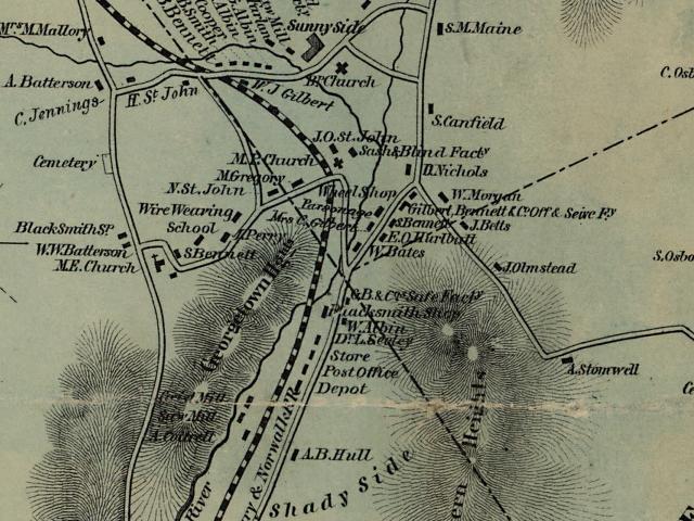
Clark's
Map of 1856 showing Old Mill Road on the right. You'll notice
Old Mill
Road was far more popular than Route 7 (road on the left)
at that time period.
As
the towns grew and the intervening section became thickly
settled, the "Old Turnpike" became a congested thorough-fare.
Historian Wilbur F. Thompson explained that his grandfather,
Aaron Bennett, said "in his boyhood days (1818) there was
an unending procession of great canvas-topped freight wagons,
stage coaches, slow-moving ox carts. Travelers on horseback
and on "Shanks Mares" (pedestrians) passing both ways night
and day." At about this date the Sugar Hollow Turnpike
was opened up. Starting at Belden's Bridge, Norwalk (now Wilton)
on the west side of the Norwalk River, up through Georgetown
and into the Sugar Hollow Valley, along the course of the
river, through the town of Ridgefield, and into the western
side of Danbury. This is now [Route 7] the state road from
Danbury to Norwalk.
Back
to TOP | Back to Redding
Section | Back to Georgetown
Section
|
|